1992 No. 1696
The Greater London and Hertfordshire (County Boundaries) Order 1992
Made
Laid before Parliament
Coming into force
for the purposes referred to in article 1(2)
for all other purposes
The Secretary of State, in exercise of his powers under sections 51(2) and 67(4) of the Local Government Act 19721 and of all other powers enabling him in that behalf, hereby makes the following Order which gives effect to proposals submitted to him under sections 47, 48(1) and 51(1) of that Act, more than six weeks before the making of this Order, by the Local Government Boundary Commission for England:
Citation and commencement1
1
This Order may be cited as the Greater London and Hertfordshire (County Boundaries) Order 1992.
2
This Order shall come into force on 5th August 1992 for any purpose set out in regulation 4(1) of the Local Government Area Changes Regulations 19762.
3
For all other purposes, this Order shall come into force on 1st April 1993.
Interpretation2
In this Order—
“Barnet” means the London Borough of Barnet;
“electoral division” means an electoral division of the county of Hertfordshire;
“Harrow” means the London borough of Harrow;
“Hertfordshire” means the county of Hertfordshire;
“Hertsmere” means the borough of Hertsmere;
“the map” means one or both of the 2 maps prepared by the Department of the Environment, marked “Maps of the Greater London and Hertfordshire (County Boundaries) Order 1992”, and deposited in accordance with regulation 5 of the Local Government Area Changes Regulations 1976; and
“ward” means a ward of the borough to which an area is transferred, except where the expression “parish ward” appears, when it refers to a ward of the parish to which an area is transferred.
Transfers from Greater London to Hertfordshire3
Each area of Greater London which is marked as shown in column 1 of the following Table on the map indicated in column 2 shall be transferred from the London borough mentioned in column 3 to—
a
Hertfordshire;
b
Hertsmere;
c
the parish and parish ward (if any) mentioned in column 4;
c
the ward and electoral division so mentioned; and to—
d
the South Mimms petty sessional division and the St Albans and Watford coroner’s district.
Area marked | On map | Transferred from Greater London, and from | To Hertfordshire and to Hertsmere, and to— |
|---|---|---|---|
C2 | 1 and 2 | Barnet | Parish of Elstree and Borehamwood Elstree parish ward Elstree ward Elstree electoral division |
C3 and C4 | 1 | Barnet | Parish of Elstree and Borehamwood Hillside parish ward Hillside ward Elstree electoral division |
C5 and C6 | 1 | Barnet | Parish of Elstree and Borehamwood Kenilworth parish ward Kenilworth ward Elstree electoral division |
C7 | 1 | Barnet | Parish of Elstree and Borehamwood Cowley parish ward Cowley Ward Lyndhurst electoral division |
C8 | 1 | Barnet | Parish of Ridge Potters Bar West ward Potters Bar South West electoral division |
B2 | 1 | Barnet | Unparished area Potters Bar West ward Potters Bar South West electoral division |
C1 | 2 | Harrow | Parish of Elstree and Borehamwood Elstree parish ward Elstree ward Elstree electoral division |
Transfers from Hertfordshire to Greater London (Barnet)4
1
The area marked B1 on map 1 shall be transferred from Hertfordshire, from Hertsmere and from the parish of Elstree and Borehamwood to Greater London, to Barnet, and to the Arkley ward. It shall cease to form part of any parish.
2
The areas marked B3, B4 and B5 on map 1 shall be transferred from Hertfordshire and from Hertsmere to Greater London, to Barnet, and to the Hadley ward. They shall continue to be unparished.
3
The areas transferred by paragraphs (1) and (2) shall additionally be transferred to the Barnet petty sessional division and to the Northern London coroner’s district.
Town and country planning5
1
In this article, “provision” means a provision of a development plan (as defined in section 336(1) of the Town and Country Planning Act 19903).
2
Any provision applying to an area transferred by this Order shall continue to apply to that area, notwithstanding the transfer, until replaced by a provision which so applies, and which is expressed to supersede the preserved provision.
Signed by authority of the Secretary of State for the Environment
(This note is not part of the Order)
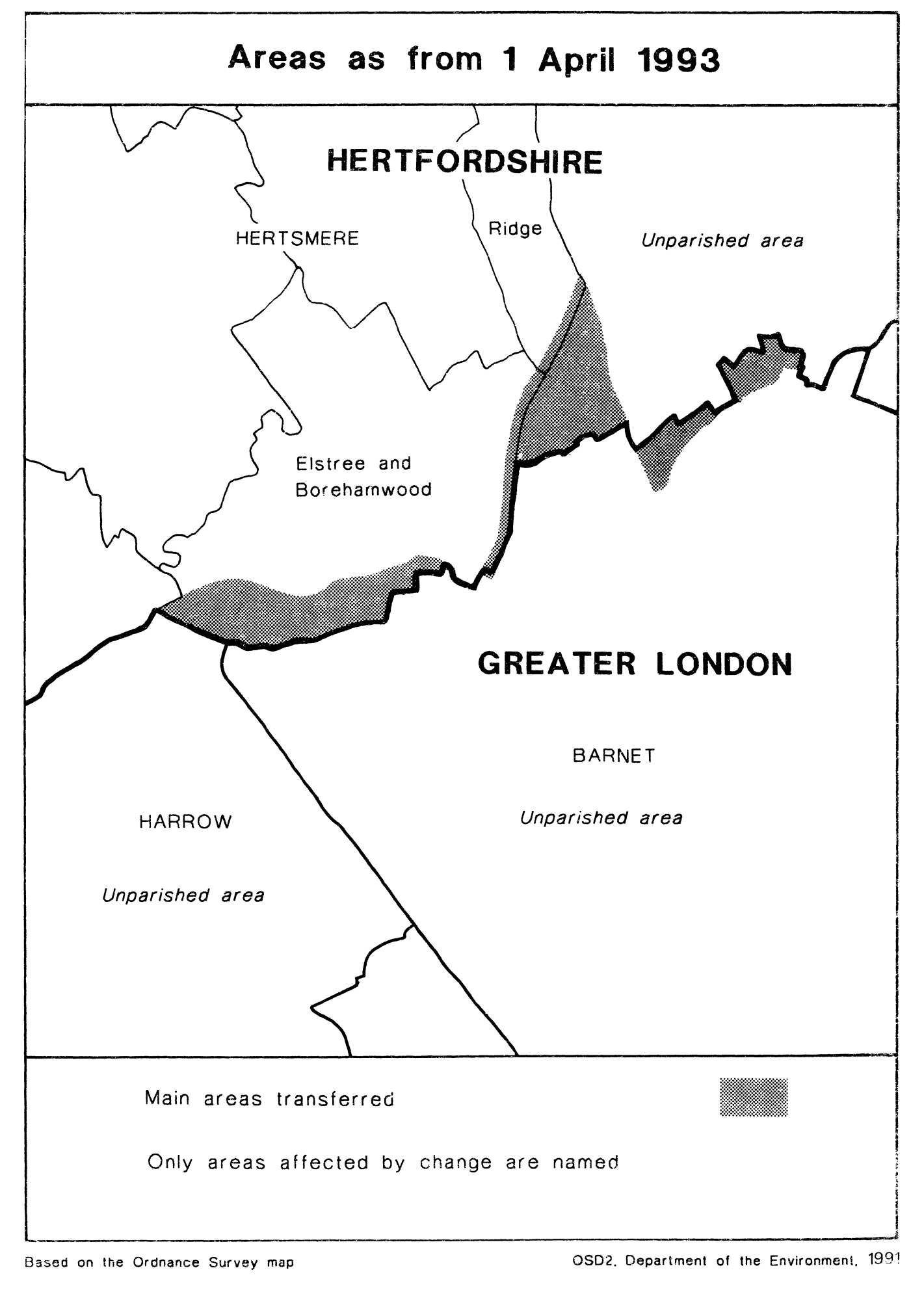
This Order transfers areas between the counties of Greater London and Hertfordshire, affecting the boundaries of the London boroughs of Barnet and Harrow, and of the Hertfordshire borough of Hertsmere. Consequential changes to parishes, unparished areas, local government electoral areas, petty sessional divisions and coroners' districts are made.
The map and table forming part of this note (pages 4 and 5) give a general guide to the areas affected. Prints of the details maps (described in article 2) may be inspected at all reasonable times at the offices of the council for each borough affected, and additionally at the offices of the Secretary of State for the Environment located in 2, Marsham Street, London SW1P 3EB.
In approximate terms, the parts of Greater London transferred to Hertsmere have a total area of 370 hectares, and 1648 inhabitants, and the parts of Hertfordshire transferred to Greater London have a total area of 80 hectares and a population of 393.
The Local Government Area Changes Regulations 1976 contain general provisions regarding the effect of orders such as this one.
Table showing main changes effected
Transfer—
From Harrow to Hertsmere of area located to the north of A61 road, to south of A411 road, to south-east of Aldenham Reservoir and to the west of Elstree Hill South, including residential development, playing fields, community centre and works.
From Barnet to Hertsmere of area to the north of the A61 road, stretching from Elstree Hill South in the west to the vicinity of Furze Hill in the east, and including Edgwarebury House Farm, The Leys, Edgewarebury Country Club, The Dower House, Deacons Hill and Woodcock Farm.
From Barnet to Hertsmere of area to the east of the A1 road in vicinity of Dyrham Park and Galley Lane, including Valentine’s Farm, Saffron Green, Galley Lane Farm and part of Arkley Lane.
From Hertsmere to Barnet of area to the east of Galley Lane, including housing development north-west of Whalebone Park, and Byng Road Playing Fields.
From Hertsmere to Barnet of area east of St. Albans Road and west of Kitt’s End Road, including part of golf course, and the properties known as Cole Brook Court and Hadley Lawns.
From Hertsmere to Barnet of area to east of Kitt’s End Road, including Warwick Gardens.
Realignment of boundary between Barnet and Hertsmere to centre of A1 road, stretching from the vicinity of Holmeshill Lane southwards to the vicinity of Froghall Wood and the Barnet by-pass.