1993 No. 1445
The City and London Borough Boundaries Order 1993
Made
Laid before Parliament
Coming into force
for the purposes referred to in article 1(2)
for all other purposes
The Secretary of State, in exercise of his powers under sections 51(2) and 67(4) of the Local Government Act 19721 and of all other powers enabling him in that behalf, hereby makes the following Order which gives effect to proposals submitted to him under sections 47, 48(1) and 51(1) of that Act, more than six weeks before the making of this Order, by the Local Government Boundary Commission for England:
Citation and commencement1
1
This Order may be cited as the City and London Borough Boundaries Order 1993.
2
This Order shall come into force on 1st December 1993 for any purpose set out in regulation 4(1) of the Local Government Area Changes Regulations 19762.
3
For all other purposes, this Order shall come into force on 1st April 1994.
Interpretation2
In this Order—
“the City” means the City of London; any reference to Camden, Hackney, Islington or Tower Hamlets is a reference to the London borough of that name;
“the map” means one of the 3 maps prepared by the Department of the Environment, marked “Maps of the City and London Borough Boundaries Order 1993”, duly numbered for reference, and deposited in accordance with regulation 5 of the Local Government Area Changes Regulations 1976;
any reference to a ward is a reference to a ward of the London borough or city from or to which an area is transferred and
“Westminster” means the city of Westminster.
Transfers between Camden and the City3
1
The areas marked D and F on map 1 shall be transferred from the City, and from the Farringdon Without ward to—
a
Camden;
b
the Holborn ward;
c
the West Central petty sessional area;
d
the Inner North London coroner’s district; and to
e
the Metropolitan Police District.
2
The areas marked C, E and G on map 1 shall be transferred from Camden, and from the Holborn ward to—
a
the City;
b
the Farringdon Without ward;
c
the East Central petty sessional area; and to
d
the City of London coroner’s district;
and shall cease to form part of the Metropolitan Police District.
Transfers from Hackney to the City4
The area marked D on map 2 shall be transferred from Hackney, and from the Moorfields ward to—
a
the City;
b
the Bishopsgate ward;
c
the City of London petty sessional area; and to
d
the City of London coroner’s district; and shall cease to form part of the Metropolitan Police District.
Transfer between the City and Islington5
1
The following areas of the City—
a
the part of the Coleman Street ward marked C on map 2; and
b
the part of the Farringdon Without ward marked J on map 1—
shall be transferred to Islington, to the East Central petty sessional area, and to the Inner North London coroner’s district. The area marked C on map 2 shall be transferred to the Bunhill ward, and that marked J on map 1 to the Clerkenwell ward. These areas shall form part of the Metropolitan Police District.
2
Each area of Islington described in column 1 of the following Table shall be transferred to the City, to the ward named in column 2, to the City of London petty sessional area, and to the City of London coroner’s district and shall cease to form part of the Metropolitan Police District.
(1) | (2) |
|---|---|
Description of area of Islington— | Transferred to the City, and to the following ward— |
The part of the Clerkenwell ward marked K on map 1 | Farringdon Without |
The part of the Bunhill ward marked L on map 1 | Cripplegate |
The parts of the Bunhill ward marked A and B on map 2 | Cripplegate |
Transfer from Camden to Islington6
The area marked H on map 1 shall be transferred from Camden, and from the Holborn ward to—
a
Islington;
b
the Clerkenwell ward;
c
the East Central petty sessional area.
Transfers between the City and Tower Hamlets7
1
Each area of the City described in column 1 of the following Table shall be transferred to Tower Hamlets, to the ward named in column 2, to the Thames petty sessional area, to the Inner North London coroner’s district, and shall form part of the Metropolitan Police District.
(1) | (2) |
|---|---|
Description of area of the City | Transferred to Tower Hamlets, to the following ward— |
The part of the Bishopsgate ward marked E on map 2 | Spitalfields |
The parts of the Portsoken ward marked A, C and E on map 3 | St Katherine's |
The parts of the Tower ward marked H and K on map 3 | St Katherine's |
2
Each area of Tower Hamlets described in column 1 of the following Table shall be transferred to the City, to the ward named in column 2, to the City of London petty sessional area, and to the City of London coroner’s district and shall cease to form part of the Metropolitan Police District.
(1) | (2) |
|---|---|
Description of area of Tower Hamlets | Transferred to the City, and to the following ward— |
The part of the Spitalfields ward marked F on map 2 | Bishopsgate |
The part of St Katherine’s ward marked F on map 3 | Aldgate |
The parts of St Katherine’s ward marked B and D on map 3 | Portsoken |
The parts of St Katherine’s ward marked G, I and J on map 3 | Tower |
Transfers between the City and Westminster8
1
The area marked A on map 1 shall be transferred from the City, and from the Farringdon Without ward to—
a
Westminster;
b
the St James’s ward;
c
the Inner West London coroner’s district; and to
d
the Metropolitan Police District.
2
The area marked B on map 1 shall be transferred from Westminster, and from the St James’s ward to—
a
the City;
b
the Farringdon Without ward; and to
c
the City of London coroner’s district; and shall cease to form part of the Metropolitan Police District.
Town and Country Planning9
1
In this article, “provision” means a provision of a development plan (as defined in section 336(1) of the Town and Country Planning Act 19903).
2
Any provision applying to an area transferred by this Order shall continue to apply to that area, notwithstanding the transfer, until replaced by a provision which so applies, and which is expressed to supersede the preserved provision.
Street Trading10
The provisions of Part III of the London Local Authorities Act 19904 (Street Trading) shall continue to apply to the areas transferred to the City by virtue of articles 3(2), 4, 5(2), 7(2) and 8(2) and for the purposes of the said Part III the City shall be treated as a participating council.
Signed by authority of the Secretary of State
(This note is not part of the Order)
This Order makes changes to the boundary between the City of London and
i
the London boroughs of Camden, Hackney, Islington, and Tower Hamlets;
ii
the city of Westminister.
It also makes a minor consequential change to the boundary between Camden and Islington.
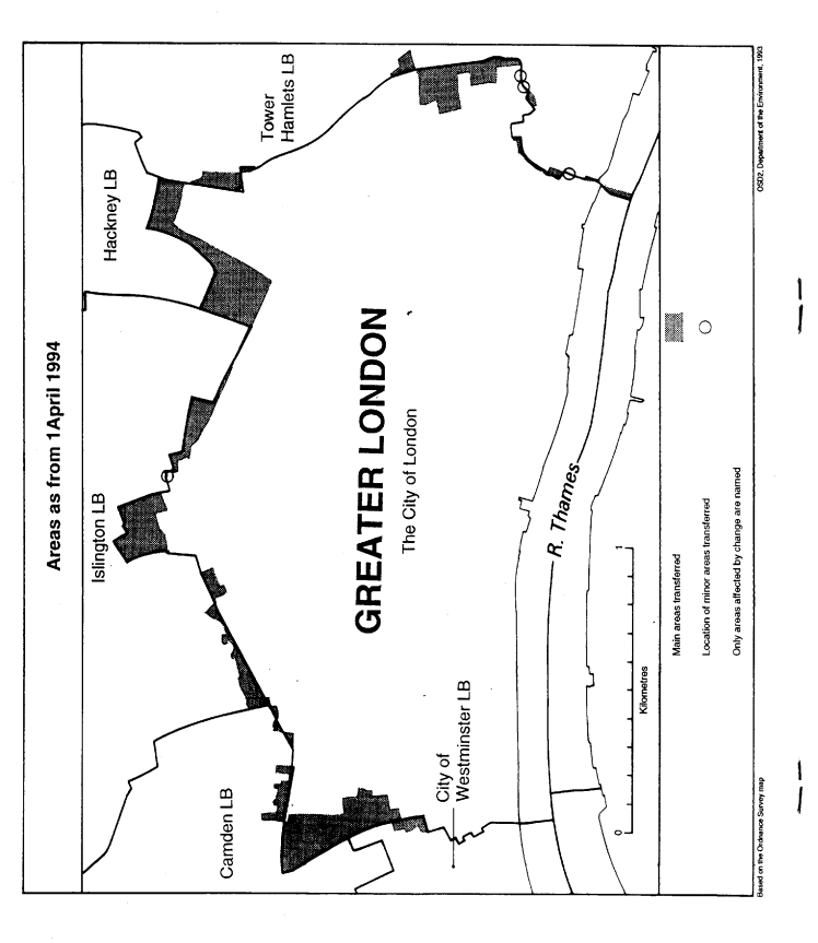
The map and table forming part of this Note (Pages 4 and 5) give a general guide to the changes made, and areas and population affected.
For full details of the transfers made, the order maps (described in article 2) should be inspected.
Any person may inspect them at any reasonable time at the offices of the council for each city or London borough affected, and also at the offices of the Secretary of State for the Environment, 2, Marsham Street, London SW1P 3EB.
Consequential changes are made to petty sessional areas, coroners' districts and to the Metropolitan Police District.
The Local Government Area Changes Regulations 1976 (S. I. 1976/246, amended by S. I. 1978/247) contain general provisions regarding the effect of orders such as this one.
Transfers | General description of changes— |
|---|---|
Between Camden and the City (Article 3) Area: 15 hectares Population: 20 | Transfer to Camden of part of Holborn to the east of Grays Inn Road. Transfer to the City of area to the east of Chancery Lane, and south of High Holborn, including Chancery House, Southampton Buildings, and Staple Inn. Minor realignments to centre of road in Charterhouse Street, commencing at its junction with Holborn Viaduct, and terminating in the vicinity of Farringdon Road. |
From Hackney to the City (Article 4) Area: 15 hectares Population: 0 | Transfer to the of part of the Broadgate City development, so that boundary follows the centre of Wilson Street, Sun Street, Appold Street and Worship Street. |
Between the City and Islington (Article 5) Area: 10 hectares Population: 750 | Transfer to the City of parts of the Barbican complex and Golden Lane Estate, so that boundary follows centre of Goswell Road, Baltic Street and Golden Lane. Realignments in following areas—
|
From Camden to Islington (Article 6) Area: less than 1 hectare Population: 0 | Minor realignment at junction of Farringdon Road and Charterhouse Street. |
Between the City and Tower Hamlets (Article 7) Area: 15 hectares Population: 485 | Transfer to the City of area lying to the west of Mansell Street and to the east of the Minories. Realignments—
|
Between the City and Westminster (Article 8) Area: 5 hectares Population: 0 | Transfer to the City of area to the east of Chancery Lane, running from Cursitor Street southwards to the southern side of the Public Record Office building. Transfer to Westminster of area located to the east of the Royal Courts of Justice, at the junction of Chancery Lane with Fleet Street. |