1993 No. 441
The Essex, Greater London and Hertfordshire (County and London Borough Boundaries) Order 1993
Made
Laid before Parliament
Coming into force for
the purposes referred to in article 1(2)
for all other purposes
The Secretary of State, in exercise of his powers under sections 51(2) and 67(4) of the Local Government Act 19721 and of all other powers enabling him in that behalf, hereby makes the following Order which gives effect, with modifications, to proposals submitted to him under sections 47, 48(1) and 51(1) of that Act, more than six weeks before the making of this Order, by the Local Government Boundary Commission for England:
Citation and commencement1
1
This Order may be cited as the Essex, Greater London and Hertfordshire (County and London Borough Boundaries) Order 1993.
2
This Order shall come into force on 1st December 1993 for any purpose set out in regulation 4(1) of the Local Government Area Changes Regulations 19762.
3
For all other purposes, this Order shall come into force on 1st April 1994.
Interpretation2
In this Order–
“Barnet” means the London borough of Barnet;
“district” includes a London borough;
“electoral division” means an electoral division of the county to which an area is transferred by this Order3;
“Enfield” means the London borough of Enfield;
“Essex” means the county of Essex, and any reference to Epping Forest is a reference to the Essex district of that name;
“Hertfordshire” means the county of Hertfordshire, and any reference to Broxbourne, to Hertsmere or to Welwyn Hatfield is a reference to the Hertfordshire district of that name;
“the map” means one or more of the 11 maps prepared by the Department of the Environment, marked “Maps of the Essex, Greater London and Hertfordshire (County and London Borough Boundaries) Order 1993”, duly numbered for reference, and deposited in accordance with regulation 5 of the Local Government Area Changes Regulations 1976;
any reference to an area as unparished is a reference to that area not forming part of any parish; and
“ward” means a ward of the district to which an area is transferred4, except in the expression “parish ward”, where it means a ward of the parish to which an area is transferred.
Transfers from Greater London (Enfield) to Hertfordshire3
1
Each area which is marked as shown in column 1 of the following Table on the map indicated in column 2 shall be transferred from Greater London, from Enfield and from the ward named in column 3 to–
a
Hertfordshire;
b
Broxbourne;
c
the ward and electoral division named in column 4; and to
d
the Cheshunt petty sessional division, and the Hertford coroner’s district–
and shall remain unparished.
1. | 2. | 3. | 4. |
|---|---|---|---|
Area marked— | On map— | Transferred from Greater London, from Enfield and from the following ward— | To Hertfordshire, and to— |
F & G | 9 | Bullsmoor | Waltham Cross South ward |
B | 10 | Waltham Cross electoral division | |
E & G | 10 | Enfield Lock | Waltham Cross South ward |
K | 11 | Waltham Cross electoral division | |
A & C | 9 | Worcesters | Bury Green ward Cheshunt Central electoral division |
2
The unparished area which is marked A on map 8 shall be transferred from Greater London, from Enfield and from the Chase ward to–
a
Hertfordshire;
b
Welwyn Hatfield;
c
the parish of Northaw and Cuffley, and the Northaw and Cuffley parish ward;
d
the Northaw ward and North Mymms electoral division; and to
e
the Cheshunt petty sessional division and the Hertford coroner’s district.
Transfers from Hertfordshire to Greater London (Enfield)4
1
Each area which is marked as shown in column 1 of the following Table on the map indicated in column 2 shall be transferred from Hertfordshire, from Broxbourne, and from the ward named in column 3 to–
a
Greater London;
b
Enfield;
c
the ward named in column 4; and to
d
the Enfield petty sessional area and the Northern London coroner’s district–
and shall remain unparished.
1. | 2. | 3. | 4. |
|---|---|---|---|
Area marked– | On map– | Transferred from Hertfordshire, from Broxbourne, and from the following ward– | To Greater London, to Enfield, and to the following ward– |
E | 8 | Bury Green | Worcesters |
B & D | 9 | ||
C | 8 | Goffs Oak | Chase |
D | 8 | Goffs Oak | Worcesters |
E | 9 | Waltham Cross | Bullsmoor |
A & C | 10 | South | |
D & F | 10 | Waltham Cross | Enfield Lock |
H | 10 & 11 | South |
2
The area which is marked A on map 7 shall be transferred from Hertfordshire, from Hertsmere and from the Potters Bar South ward to Greater London, to Enfield, to the Trent ward, to the Enfield petty sessional area, and to the Northern London coroner’s district, remaining unparished.
3
The area which is marked B on map 8 shall be transferred from Hertfordshire, from Welwyn Hatfield, and from the parish of Northaw and Cuffley to Greater London, to Enfield, to the Chase ward, and to the Enfield petty sessional area and the Northern London coroner’s district, becoming unparished.
Transfers between Essex (Epping Forest) and Greater London (Enfield)5
1
The area which is marked M on map 11 shall be transferred from Essex, from Epping Forest, and from the parish of Waltham Abbey to–
a
Greater London;
b
Enfield;
c
the Enfield Lock ward; and to
d
the Enfield petty sessional area and the Northern London coroner’s district–
and shall become unparished.
2
The unparished area which is marked L on map 11 shall be transferred from Greater London, from Enfield, and from the Enfield Lock ward to–
a
Essex;
b
Epping Forest;
c
the parish of Waltham Abbey, and the West parish ward;
d
the Waltham Abbey West ward and the Waltham Abbey electoral division; and to
e
the Epping and Ongar petty sessional division and the Essex No. 1 coroner’s district.
Transfers within Greater London between Barnet and Enfield6
1
Each area which is marked as shown in column 1 of the following Table on the Map indicated in column 2 shall be transferred from Barnet, and from the ward named in column 3 to Enfield, to the ward named in column 4, and to the Enfield petty sessional area.
1. | 2. | 3. | 4. |
|---|---|---|---|
Area marked– | On map– | Transferred from Barnet, and from the following ward– | To Enfield, and to the following ward– |
C & D | 1 | Brunswick Park | Arnos |
A & B | 4 | Brunswick Park | Oakwood |
A | 5 | ||
F | 1 | Brunswick Park | Southgate Green |
A | 2 | ||
C | 3 & 4 | ||
G & H | 5 | East Barnet | Trent |
A & C | 6 | ||
A | 1 | Woodhouse | Arnos |
2
Each area which is marked as shown in column 1 of the following Table on the map indicated in column 2 shall be transferred from Enfield, and from the ward named in column 3 to Barnet, to the ward mentioned in column 4, and to the Barnet petty sessional area.
1. | 2. | 3. | 4. |
|---|---|---|---|
Area marked– | On map– | Transferred from Enfield, and from the following ward– | To Barnet, and to the following ward– |
B | 1 | Arnos | Brunswick Park |
B | 5 | Oakwood | Brunswick Park |
C & D | 5 | Oakwood | East Barnet |
E & G | 1 | Southgate Green | Brunswick Park |
B | 2 | ||
D | 3 | ||
E & F | 5 | Trent | East Barnet |
B | 6 |
Town and country planning7
1
In this article, “provision” means a provision of a development plan (as defined in section 336(1) of the Town and Country Planning Act 19905).
2
Any provision applying to an area transferred by this Order shall continue to apply to that area, notwithstanding the transfer, until replaced by a provision which so applies, and which is expressed to supersede the preserved provision.
Signed by authority of the Secretary of State for the Environment
(This note is not part of the Order)
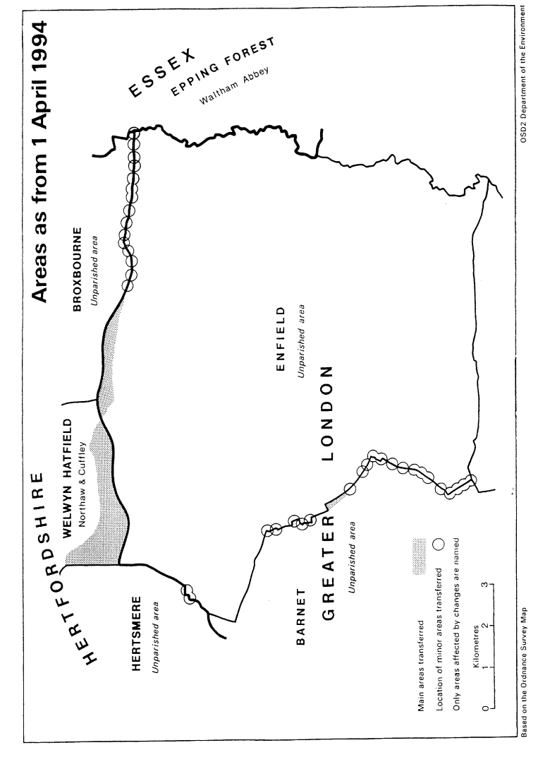
This Order makes mainly minor changes to the boundary of the London borough of Enfield with–
a
Hertfordshire (districts of Broxbourne, Hertsmere and Welwyn Hatfield);
b
Essex (district of Epping Forest); and
c
the London borough of Barnet. Consequential changes are made to the boundaries of parishes, local government electoral areas, petty sessional divisions and coroners' districts.
The map and table forming part of this Note (Pages 5 to 7) give a general guide to the location, area and population of the land affected. Prints of the detailed order maps (described in article 2) may be inspected at all reasonable times at the offices of the council for each borough or district affected, and additionally at the offices of the Secretary of State for the Environment located in 2, Marsham Street, London SW1P 3EB.
The Local Government Area Changes Regulations 1976 (S.I.1976/246, Amended by S.I.1978/247) contain general provisions regarding the effect of orders such as this one.
Transfers– | Description– |
|---|---|
In Articles 3 and 4Between Greater London (Enfield) and Hertfordshire (Broxbourne, Hertsmere and Welwyn Hatfield) Transferred from Enfield– Area: 220 hectares Population: 30 Transferred to Enfield– Area: 84 hectares Population: 34 | Realignment of Broxbourne/Enfield boundary to northern side of M25 motorway at the following locations– The Paddocks/Burntfarm Ride/north of Glasgow Stud and Whitewebbs Farm/south of western Jewish Cemetery and County Brook Plantation/at Great Cambridge Road roundabout/Holmesdale Tunnel/Hertford Road/Britannia Business Park/south of New Ford Road. Transfer to Welwyn Hatfield of area north of M25 motorway and south of Coopers Lane Road, and lying between the Welwyn/Hertsmere boundary in the west and Cattlegate Farm in the east. Properties transferred include Chequers Mead, Woodhurst, Woodhurst Farm Cottage, Woodhurst Farm and part of Cattlegate Farm. Transfer to unite properties in Waggon Road in Enfield. |
In Article 5Between Greater London (Enfield) and Essex (Epping Forest) Transferred from Enfield– Area: 0.25 hectare Population: Nil Transferred to Enfield– Area: 700 square metres Population: Nil | Minor realignments in the vicinity of the River Lee Navigation at Rammey Marsh. |
In Article 6Between the London boroughs of Barnet and Enfield | Transfer to Barnet of area in Mount Pleasant/Ashhurst Road. Transfer to Barnet of area on western side of Chase Side south of Oaktree School. |
Transferred from Enfield– Area: 10 hectares Population: 232 | Realignments in the following locations–
|
Transferred to Enfield– Area: 8 hectares Population: 112 | Station/Friern Barnet Road/Bowes Road;
|