- Latest available (Revised)
- Original (As made)
The Traffic Signs Regulations and General Directions 2016
You are here:
- UK Statutory Instruments
- 2016 No. 362
- SCHEDULE 11

What Version
More Resources
Status:
This is the original version (as it was originally made). This item of legislation is currently only available in its original format.
Regulation 3, Direction 3
SCHEDULE 11Signs that give information, are advisory or guide traffic
This schedule has no associated Explanatory Memorandum
PART 1Provisions applying to signs in Part 2
1. Except for item 75, a warning or information of a description in column 2 of an item in the Part 2 sign table must be conveyed by a sign which is—
(a)of the colour and type; and
(b)complies with the requirements as to size,
shown in the diagram in column 3 of the item, or that diagram as varied in accordance with column 4 (by reference to paragraphs in Part 5).
2. In respect of item 75 (traffic mirror), the mirror must be as specified in column 3.
3. A paragraph of Part 6, specified by reference to a number in column 5 of an item in the Part 2 sign table, applies to the sign provided for at that item.
4. A number in column 6 of an item in the Part 2 sign table indicates that the Schedule 11 General Direction bearing that number applies to the sign provided for at that item.
PART 2Advisory signs
Sign table — Schedule 11, Part 2
(1) Item | (2) Description | (3) Diagram | (4) Variants by reference to Part 5 | (5) Applicable provisions in Part 6 | (6) Schedule 11 General Directions |
|---|---|---|---|---|---|
| 1 | Diagram 811A and 811B Beginning and end of section of road where traffic has priority over vehicles from the opposite direction | 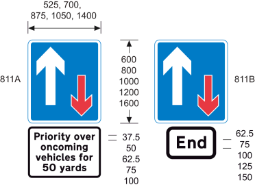 | 1, 2 | ||
| 2 | Diagram 810 One-way traffic (Sign for pedestrians) (Alternative types) | 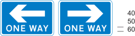 | 5 | ||
| 3 | Diagrams 814.2 and 814.4 Ramped access to or from a pedestrian subway or overbridge | 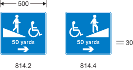 | 1, 2, 4, 5, 54 | 5 | |
| 4 | Diagrams 814.1 and 814.3 Stepped access to and from a pedestrian subway or overbridge | 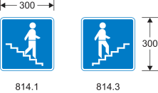 | 4 | 5 | |
| 5 | Diagram 816 No through road for vehicular traffic (Alternative types) |  | |||
| 6 | Diagram 816.1 Alternative to the sign shown at item 5 with a street nameplate | 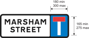 | 7 | 5 | |
| 7 | Diagram 817 No through road for vehicular traffic in direction indicated from junction ahead (Alternative types) | 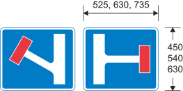 | 6 | ||
| 8 | Diagram 821 Road ahead only wide enough for one line of vehicles, and providing information about passing places (Alternative types) | 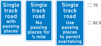 | 1 | ||
| 9 | Diagram 822 Passing place on narrow road | 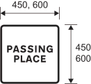 | |||
| 10 | Diagrams 892 and 893 Name and length of a tunnel on a motorway (892) or all‑purpose road (893) | 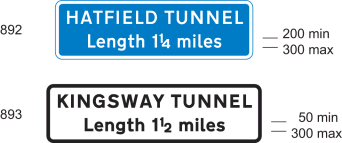 | 8 | ||
| 11 | Diagram 818.1 Section of dual carriageway road ahead | 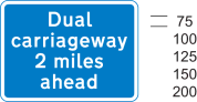 | 1, 2 | ||
| 12 | Diagram 818.1A Distance over which a short length of dual carriageway road beginning directly ahead extends (Alternative types) | 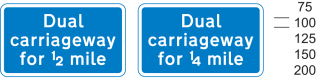 | |||
| 13 | Diagram 820.1 Absence of hard shoulder for the distance shown (Alternative types) | 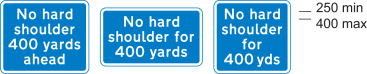 | 1 | ||
| 14 | Diagrams 873 and 874 Additional traffic joining from the left or right ahead (diagram shows blue background – for use on motorways) | 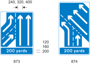 | 1, 2, 6, 26, 27 | ||
| 15 | Diagram 872.1 The number of traffic lanes reduces ahead (diagram shows blue background – for use on motorways) (Alternative types) | 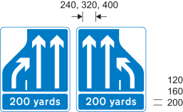 | 1, 2, 6, 26, 27 | ||
| 16 | Diagram 887 Overtaking lane ahead | 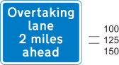 | 1, 2 | ||
| 17 | Diagram 888 Indication of length of road over which an overtaking lane is available on a single carriageway road, with a single traffic lane in the opposite direction (diagram shows green background – for use on primary routes) | 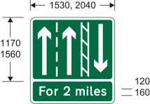 | 1, 27 | ||
| 18 | Diagram 889 Indication that only one lane of traffic, with no overtaking, is available on a single carriageway road with two traffic lanes in the opposite direction (diagram shows green background – for use on primary routes) | 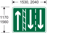 | 27 | ||
| 19 | Diagram 890 Distance ahead to a point where an overtaking lane ends on a single carriageway road (diagram shows green background – for use on primary routes) | 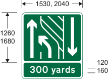 | 1, 2, 27 | ||
| 20 | Diagram 891 Distance ahead to a point where an overtaking lane ends on a single carriageway road on the approach to a dual carriageway road with only one traffic lane in each direction (diagram shows green background – for use on primary routes) | 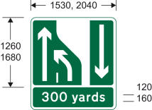 | 1, 2, 27 | ||
| 21 | Diagrams 823, 824 and 825 Distance in hundreds of yards to a roundabout or the next point at which traffic may leave a route (diagram shows blue background – for use on motorways) | 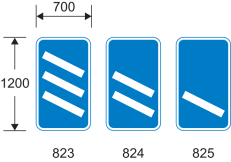 | 4, 26, 27 | ||
| 22 | Diagram 877 Appropriate traffic lanes for different manoeuvres at a junction ahead (diagram shows white background – for use on non-primary routes) (Alternative types) | 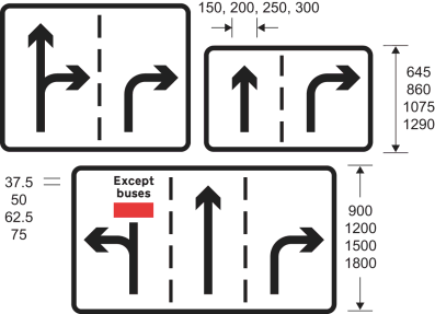 | 9, 26, 28 | ||
| 23 | Diagram 820 Route unsuitable for type of vehicle indicated (Alternative types) | 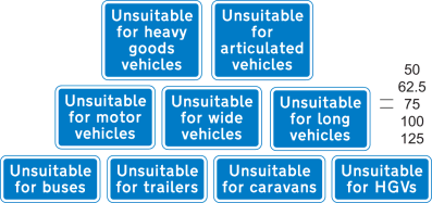 | 5(1) | ||
| 24 | Diagram 820A Road unsuitable for heavy goods vehicles (Alternative types) | 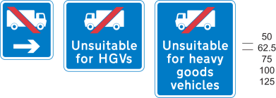 | 4, 5(1) | ||
| 25 | Diagram 829.5 Area where police carry out checks on the speed of vehicles | 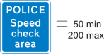 | |||
| 26 | Diagram 829.6 Waiting place for police or authorised vehicles only (Alternative types) | 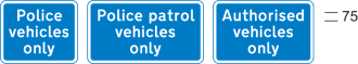 | |||
| 27 | Diagram 881 Start of a home zone designated under section 268 of the Transport Act 2000(1), or section 74(1) of the Transport (Scotland) Act 2001(2) |  | 24 | ||
| 28 | Diagram 882 End of a home zone indicated by the sign at item 27 | 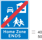 | |||
| 29 | Diagram 886 Road ahead where motorists, cyclists and pedestrians should expect to share the same space | 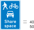 | |||
| 30 | Diagram 884 Start of a quiet lane in England designated under section 268 of the Transport Act 2000 | 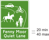 | 24 | ||
| 31 | Diagram 885 End of designated quiet lane in England | 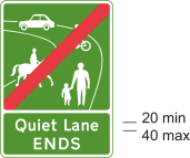 | |||
| 32 | Diagram 883 Indication of the start of area with traffic calming features (within the meaning of paragraph 1(3) of the Schedule 10 General Directions) | 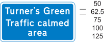 | 1, 5(1), 24 | ||
| 33 | Diagram 953.3 Entrance to a bus station, depot or garage |  | 5 | ||
| 34 | Diagram 962 Bus lane or lanes on a road at junction ahead, with indication of times of operation (Alternative types) |  | 10 | ||
| 35 | Diagram 962.1 Cycle lane on a road at junction ahead or cycle track crossing road, with indication of times of operation | 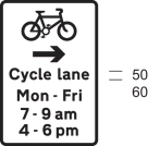 | 4, 10, 12 | ||
| 36 | Diagram 962.2 Contraflow bus lane ahead on a road at a junction which pedal cycles may also use (Alternative types) | 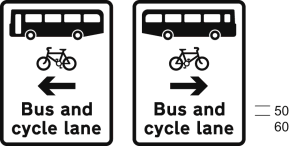 | |||
| 37 | Diagram 958 With-flow bus lane ahead which authorised vehicles, solo motor cycles, pedal cycles and taxis may also use, with indication of times of operation | 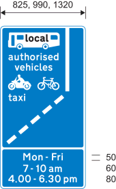 | 10, 11, 13, 14 | ||
| 38 | Diagram 958.1 With-flow mandatory cycle lane ahead, with indication of times of operation | 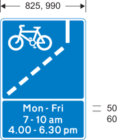 | 10, 14 | ||
| 39 | Diagram 2602.2 Numbered route for pedal cycles forming part of a regional (blue number patch) or national (red number patch) cycle route network (Alternative types) | 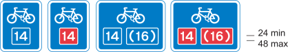 | 25 | 5 | |
| 40 | Diagram 963 Direction in which pedestrians should look for approaching traffic when crossing a bus lane (Alternative types) | 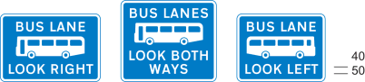 | 5 | ||
| 41 | Diagram 963.1 Direction in which pedestrians should look for approaching pedal cycles when crossing a cycle lane (Alternative types) | 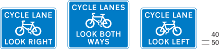 | 15 | 5 | |
| 42 | Diagram 963.2 Direction in which pedestrians should look for approaching traffic when crossing a contraflow bus lane which pedal cycles may also use (Alternative types) | 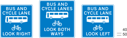 | 5 | ||
| 43 | Diagram 963.3 Direction in which pedestrians should look for approaching tramcars when crossing a tramway (Alternative types) | 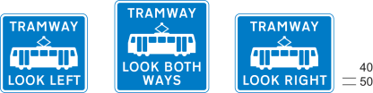 | 5 | ||
| 44 | Diagram 967 Route recommended for pedal cycles on the main carriageway of a road | 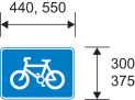 | 5 | ||
| 45 | Diagram 965 End of cycle lane, track or route | 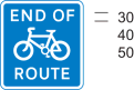 | 5 | ||
| 46 | Diagram 966 Pedal cyclists to rejoin main carriageway or dismount at the end of, or at a break in, a cycle track or route (Alternative types) |  | 5 | ||
| 47 | Diagram 968 and 968.1 Parking place for pedal cycles | 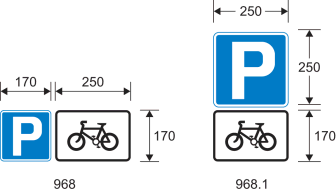 | 5 | ||
| 48 | Diagram 857.1 Information relating to a taxi rank for the number of taxis specified | 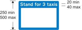 | 16 | 5 | |
| 49 | Diagram 2934 Drivers should keep or check their distance from the vehicle in front (Alternative types) | 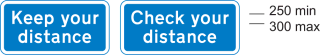 | |||
| 50 | Diagram 2933 Drivers should keep a distance of two chevron markings (the markings provided for at item 34 of the table in Part 4) from the vehicle in front |  | |||
| 51 | Diagrams 2032 and 2130 Primary route (2032) or non‑primary route (2130) forming part of a ring road | 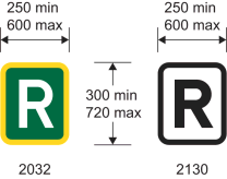 | |||
| 52 | Diagram 972 Stopping place for buses used for carrying tourists to allow passengers to take photographs | 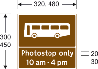 | 17, 34 | 5 | 2 |
| 53 | Diagram 857A Information for pedestrians about tourist destinations and leisure facilities in a nearby place or area | 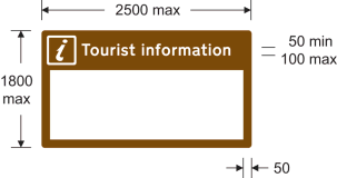 | 18, 19 | 5 | |
| 54 | Diagram 857B Information for pedestrians about tourist destinations and leisure facilities in a nearby place or area |  | 18 | 5 | |
| 55 | Diagram 2501 Distance to a parking place ahead |  | 1, 5(1) | ||
| 56 | Diagram 801 Parking place | 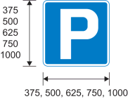 | |||
| 57 | Diagram 2713.1 Distance ahead to emergency telephone in a parking place or emergency lay‑by (Alternative types) | 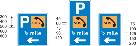 | 1, 2, 5 | ||
| 58 | Diagram 2713 Direction to nearest emergency telephone on same side of the road(diagram shows blue background – for use on motorways) (Alternative types) | 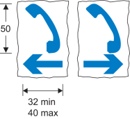 | 53 | 5 | |
| 59 | Diagram 2714 Side of emergency telephone box (Alternative types) | 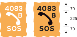 | 29, 55 | 2, 6 | |
| 60 | Diagram 2715 Back of emergency telephone box (Alternative types) | 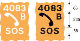 | 29, 55 | 2, 6 | |
| 61 | Diagram 2718 Route number and location reference |  | 29 | ||
| 62 | Diagram 2712 Location of fire rendezvous point (Alternative types) |  | 20 | 5 | |
| 63 | Diagram 878 Area in which enforcement cameras are in use (Alternative types) | 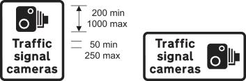 | 21 | ||
| 64 | Diagram 880 Speed camera ahead on a lit road and reminder of 30 mph speed limit | 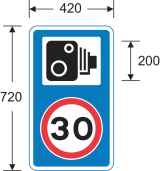 | 21(2) | ||
| 65 | Diagram 880.1 Speed camera ahead on an unlit road and reminder that a national speed limit applies | 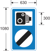 | 21(2) | ||
| 66 | Diagrams 827.1, 827.2 and 827.3 Hospital ahead | 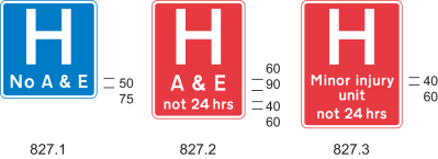 | 22 | ||
| 67 | Diagram 775 Vehicular traffic must not stop within the area of a railway or tramway level crossing |  | |||
| 68 | Diagram 783 Drivers of long low, large or slow vehicles must telephone to obtain permission before using a railway or tramway level crossing (Alternative types) | 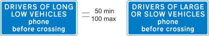 | |||
| 69 | Diagram 785.1 Name of level crossing and details of telephone number for contacting railway or tramway operator | 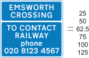 | 23 | ||
| 70 | Diagram 786 Place where large, slow or long low vehicles should wait near a railway or tramway level crossing while the driver obtains permission by telephone to cross or confirms he or she has crossed (Alternative types) |  | 56 | ||
| 71 | Diagram 787 Site of telephone or emergency telephone at or near a railway or tramway level crossing (Alternative types) | 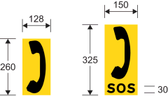 | |||
| 72 | Diagram 788 Direction to telephone or emergency telephone at or near a railway or tramway level crossing (Alternative types) | 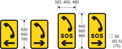 | |||
| 73 | Diagram 611 Vehicular traffic may reach the same destination by proceeding either side of the sign | 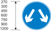 | 1, 4 | 1 | |
| 74 | Diagrams 833, 834, 835 and 836 Signs regulating the movement of vehicular traffic into and out of premises with more than one access to a road | 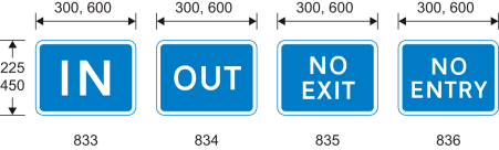 | 5 | ||
| 75 | Traffic mirror for providing additional visibility (not for use with traffic signals) | The mirror must be convex and any frame must be of a single colour, being black, grey, yellow or white | 13 | ||
| 76 | Diagram 970 Stopping place for buses | 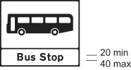 | 30, 31, 34 | 5 | 2 |
| 77 | Diagrams 973.2 and 973.3 Stopping place for buses operated by or on behalf of, or under agreement with, Transport for London | 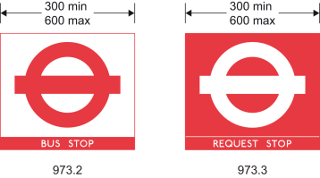 | 30, 32, 34 | 5 | 2 |
| 78 | Diagram 971 Stopping place for tramcars | 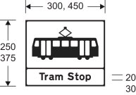 | 30, 33, 34 | 5 | 2 |
| 79 | Diagram 2928 Motorway sign indicating the boundary of an administrative area, a ceremonial area or an historic county area (Alternative types) | 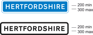 | 35 | ||
| 80 | Diagram 2401 Primary or non‑primary route sign indicating the boundary of an administrative area, a ceremonial area or an historic county area |  | 30, 36 | 5 | |
| 81 | Diagram 2402.1 Primary or non‑primary route sign indicating the name of a city, town or village commencing immediately ahead (Alternative types) | 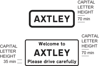 | 37 | 5 | 3 |
| 82 | Diagram 2403.1 Primary or non-primary route sign indicating the name of a city, town or village immediately ahead, together with extra local information | 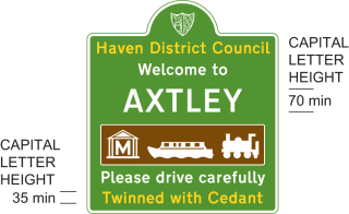 | 30, 38 | 5 | 4 |
| 83 | Diagram 2404 Primary or non-primary route sign indicating the name of a city, town, village, an administrative area, a ceremonial area or an historic county area immediately ahead, together with phrase and image that is representative of the city, town, village or area | 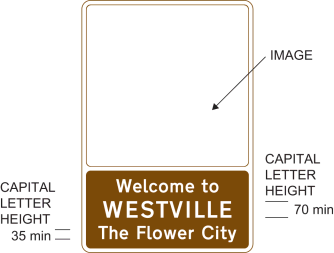 | 39 | 5 | 4 |
| 84 | Diagram 976 Maximum speed limit for tramcars in kilometres per hour | 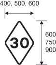 | 40 | 5 | |
| 85 | Diagram 864.2 Vehicle testing station approved by the Driver and Vehicle Standards Agency | 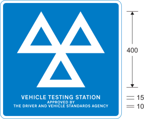 | 58 | 5 | |
| 86 | Diagram 865 Motor cycle test centre |  | 5 |
PART 3Provisions applicable to markings in Part 4
1. The warning or information of a description in column 2 of an item in the Part 4 sign table must be conveyed by road markings that are—
(a)of the colour and type; and
(b)comply with the requirements as to size,
shown in the diagram in the same column of the item, or that diagram as varied in accordance with column 3 (by reference to paragraphs in Part 5).
2. A provision of Part 6 mentioned (by reference to paragraph number) in column 4 of an item in the Part 4 sign table applies to the marking provided for at that item.
3. A reference to a “longitudinal marking” is to a marking placed on the carriageway of a road longitudinally to the flow of traffic.
PART 4Advisory road markings
Sign table — Schedule 11, Part 4
(1) Item | (2) Description and diagram | (3) Permitted or required variants in Part 5 | (4) Requirements applicable in Part 6 |
|---|---|---|---|
| 1 | Diagram 1003.1 Vehicular traffic approaching a roundabout should give way at or immediately beyond the line to vehicular traffic circulating on the carriageway of the roundabout 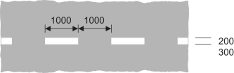 | 7 | |
| 2 | Diagram 1004 Vehicular traffic should not cross or straddle the line unless it is safe to do so and when the line is used to indicate a cycle lane, motor vehicles should not enter that lane unless it is clear of pedal cycles (Longitudinal marking)  | 57 | 7, 8, 10, 12 |
| 3 | Diagram 1004.1 Vehicular traffic should not cross or straddle the line unless it is safe to do so and when the line is used to indicate a cycle lane, motor vehicles should not enter that lane unless it is clear of pedal cycles (Longitudinal marking)  | 7, 8, 10, 12 | |
| 4 | Diagram 1005 Division of carriageway into traffic lanes on part of the carriageway where vehicles normally proceed in the same direction other than at places where the marking at item 2 of this table is used (Longitudinal marking)  | 7, 8, 10, 12 | |
| 5 | Diagram 1005.1 As the marking at item 4 other than at places where the marking at item 3 is used (Longitudinal marking) 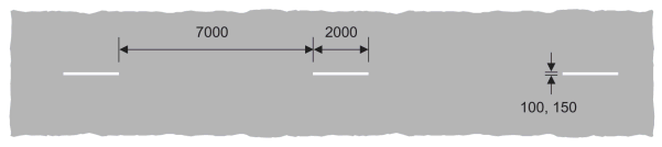 | 7, 8, 10, 12 | |
| 6 | Diagram 1008 Division between opposing flows of traffic on a carriageway other than at places where the marking at item 2 is used (Longitudinal marking)  | 57 | 7, 8, 10, 12 |
| 7 | Diagram 1008.1 Division between opposing flows of traffic on a carriageway other than at places where the marking at item 3 is used (Longitudinal marking) 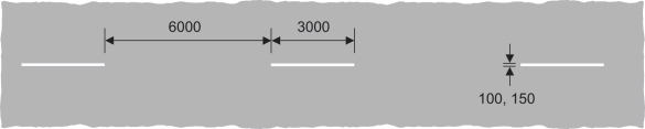 | 7, 8, 10, 12 | |
| 8 | Diagram 1009A Edge of the carriageway at a road junction, exit from a private drive onto a public road, or the start of a cycle lane (Longitudinal marking)  | 7 | |
| 9 | Diagram 1009B Edge of the carriageway at a junction of a cycle track and another road (Longitudinal marking) 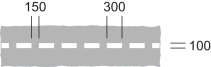 | ||
| 10 | Diagram 1010 (a) edge of the carriageway at a road junction or a lay-by, or at an exit from a private drive onto a public road; (b) the start of a traffic lane, the boundary of which is indicated by the road marking shown at item 11 of the table in Part 6 of Schedule 9; (c) when used in conjunction with the road marking at item 4 of the sign table in Part 4 of Schedule 2, the most suitable path to be taken by high vehicles under a low bridge or to avoid an overhanging structure; (d) when laid alongside rails used by tramcars, the edge of the part of the carriageway used by the tramcars; (e) the division between the main carriageway and a traffic lane which leaves the main carriageway at a junction ahead; (f) the boundary between the main carriageway and either a diverging or merging traffic lane at a road junction; (g) the boundary between an emergency refuge area and either an actively managed hard shoulder or the edge of carriageway of a motorway; or (h) the division between the main carriageway and a cycle lane through a junction (Longitudinal marking)  | 41 | 7, 8, 11, 12 |
| 11 | Diagram 1012.1 (a) edge of the carriageway available for through traffic other than at a road junction, an exit from a private drive onto a public road, lay-by or emergency refuge area; (b) the back edge of a hard shoulder; (c) the edge of a footway where it passes over a railway or tramway level crossing; or (d) the boundary between the carriageway of a motorway and an actively managed hard shoulder (Longitudinal marking)  | 7, 9, 11, 12 | |
| 12 | Diagram 1012.2 (a) edge of carriageway of a motorway other than at an emergency refuge area or a junction with a slip road; or (b) the back edge of an actively managed hard shoulder; and, in both cases, incorporating an audible and tactile warning (Longitudinal marking) 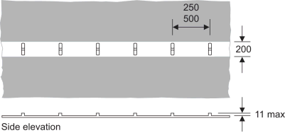 | 42 | 3, 7, 9, 11, 12 |
| 13 | Diagram 1012.3 Edge of carriageway of a road that is not a motorway and which has hard strips or hard shoulders, other than at a junction with a slip road, and incorporating an audible and tactile warning (Longitudinal marking) 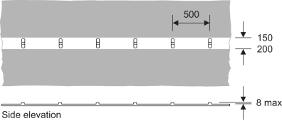 | 43 | 3, 7, 9, 11, 12 |
| 14 | Diagram 1014 (a) Direction in which vehicular traffic should pass a road marking shown at item 7, 11 or 23 of the sign table in Part 6 of Schedule 9 or at item 23, 24 or 25 of the sign table in Part 4 of this Schedule; (b) obstruction on the carriageway ahead; (c) reduction in the number to traffic lanes in the carriageway ahead; or (d) path to be taken by vehicular traffic to avoid a route available for tramcars only (Longitudinal marking) (Alternative types)  | 7 | |
| 15 | Diagram 1024 Vehicular traffic should proceed with caution because of potential danger ahead  | 7 | |
| 16 | Diagram 1026 Part of the carriageway which should be kept clear of stationary vehicles (Alternative types) 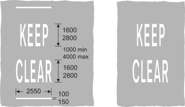 | ||
| 17 | Diagram 1026.1 Part of the carriageway outside a vehicular entrance to adjacent premises or a private drive, or where the kerb is dropped to provide a convenient crossing place for pedestrians, which should be kept clear of waiting vehicles 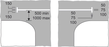 | ||
| 18 | Diagram 1029 Direction in which pedestrians should look for approaching traffic  | 44 | |
| 19 | Diagram 1035 Appropriate traffic lanes for different destinations (Alternative types)  | 45 | |
| 20 | Diagram 1038 Appropriate traffic lanes for different manoeuvres (Longitudinal marking) (Alternative types)  | ||
| 21 | Diagram 1038.1 Appropriate direction to be taken by traffic turning within a junction (Alternative types)  | 46 | |
| 22 | Diagram 1039 Place where traffic streams divide or bifurcate (Longitudinal marking) (Alternative types)  | 7 | |
| 23 | Diagram 1040 Part of the carriageway which vehicular traffic should not enter unless it is seen by the driver to be safe to do so (Alternative types) 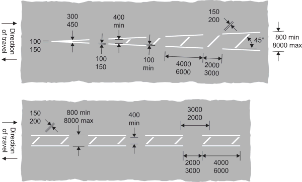 | 47 | 7, 8, 10, 12 |
| 24 | Diagram 1040.3 Reduction in the number of lanes, or area not available to traffic, on the main carriageway or slip road of a motorway or all-purpose dual carriageway road 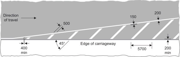 | 48 | 7, 8, 11, 12 |
| 25 | Diagram 1040.4 Part of the carriageway adjacent to the edge which vehicular traffic should not enter unless it is seen by the driver to be safe to do so 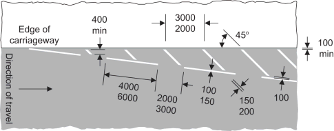 | 49 | 7, 8, 11, 12 |
| 26 | Diagram 1040.5 End of a hard shoulder 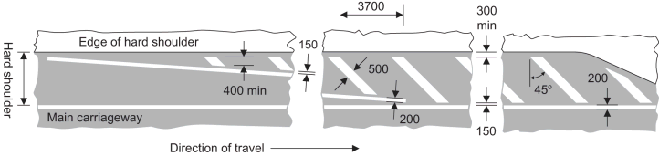 | 50 | 7, 8, 11, 12 |
| 27 | Diagram 1041 Part of the carriageway where vehicular traffic passes in the same direction on both sides of the marking, and should not enter the area covered by the marking unless it is seen by the driver to be safe to do so (Alternative types) 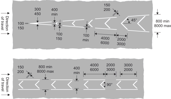 | 51 | 7, 8, 11, 12 |
| 28 | Diagram 1057 Cycle lane, track or route (Alternative types)  | ||
| 29 | Diagram 1057.1 Number of a cycle route (Alternative types)  | 29 | |
| 30 | Diagram 1058 End of a cycle lane, track or route 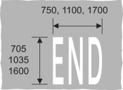 | ||
| 31 | Diagram 1058.1 Pedal cycles should proceed with caution because of potential danger ahead 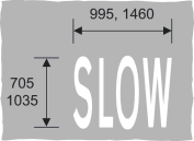 | ||
| 32 | Diagram 1059 Directions in which pedal cycles should travel along a cycle lane, track or route (Alternative types) 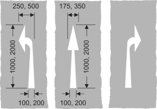 | ||
| 33 | Diagram 1062 Road hump 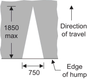 | 7 | |
| 34 | Diagram 1064 Marking used in conjunction with the sign shown at item 50 of the sign table in Part 2 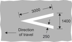 | 7 | |
| 35 | Diagram 1067 Transverse yellow bar markings for use only on approaches to roundabouts on motorways and dual carriageway roads subject to the national speed limit, either on the main carriageway or on an exit slip road  | 52 | 14, 15 |
| 36 | Diagram 1066 Edge of part of the road used by tramcars (Longitudinal marking) 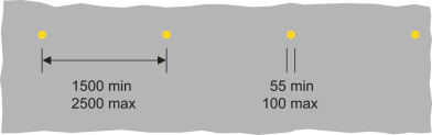 |
PART 5Permitted variants of the signs in Parts 2 and 4
1. A distance may be added or varied, but, in relation to the signs provided for at items 11 and 16 in the Part 2 sign table, the distance must not exceed two miles.
2. The distance may be omitted and, if shown in a separate panel on the sign with no other legend, the panel must be omitted.
3. The distance may be replaced by an arrow pointing horizontally to the left or to the right.
4. The symbol, or all symbols together, may be reversed in a mirror image.
5.—(1) An arrow pointing horizontally to the left or to the right may be added or reversed.
(2) The arrow may be omitted.
6. Symbols and arrows indicating the road layout may be varied.
7. The blue panel need not extend to the edge of the nameplate and the black border may be omitted.
8. The name of the tunnel and the indication of the length may be varied.
9. The legend “Except buses” may be omitted or varied to “Bus lane”, “Except cycles” or “Except buses & cycles”; the number of lanes may be varied and any arrow may indicate two directions and point horizontally to the left and ahead, horizontally to the right and ahead or horizontally to the left and to the right.
10. The time period may be varied in accordance with Part 1 of Schedule 18, or omitted and where the times are shown in a separate panel on the sign, the panel must be omitted when the times are so omitted.
11. The local bus symbol may be varied to the bus symbol shown at item 40 of the sign table in Part 2 of this Schedule.
12. The permitted variants are—
(a)the arrow and cycle symbol may be reversed (if both are reversed);
(b)“lane” may be varied to “track” in which case the arrow may be omitted and the symbol reversed;
(c)“lane” may be varied to “lanes” or “tracks” in which case the arrow must be omitted and the cycle symbol reversed.
13. “Authorised vehicles” and symbols, other than the bus symbol, may be omitted as appropriate.
14. The continuous line and the broken line may be varied to accord with the layout of the road markings—
(a)at item 10 of the sign table in Part 4 of this Schedule and item 11 of the sign table in Part 6 of Schedule 9 when placed to indicate the extent of a bus lane; or
(b)at item 8 of the sign table in Part 4 of this Schedule and item 7 of the sign table in Part 6 of Schedule 9 when placed to indicate the extent of a cycle lane.
15. The words “LANE” and “LANES” may be varied to “TRACK”.
16. The number of taxis may be varied as appropriate and information relating to the taxi services from that rank may be shown in the white space in lettering of any colour with letter height not exceeding 25 mm, or the white space may be omitted.
17. The time period may be omitted or varied in accordance with Part 1 of Schedule 18 and the face of the sign may be curved.
18.—(1) The white area is to be filled with maps or a legend in any colour with lettering of any colour.
(2) The x-height of a legend referred to in sub-paragraph (1) must not exceed 25 mm.
(3) The “i” symbol may be omitted.
(4) The sign may have more than one panel or side if each is of the design prescribed in the diagram.
19. The logo of a local tourist organisation may be added at the top of the sign.
20. The legend “No.1” may be varied to another number, a letter or a compass point.
21.—(1) The legend may be omitted or varied to “Speed cameras”, “Average speed check”, “Traffic signal and speed cameras”, “Traffic enforcement cameras”, “Police cameras”, “Police enforcement cameras” or “Bus lane cameras”.
(2) The legend may include, or a legend may be added for, the name, and logo, of the enforcement authority.
22. “not 24 hrs” may be omitted.
23. The name or location of the crossing in the top panel may be varied as appropriate and may be displayed on any number of lines; “TO CONTACT RAILWAY” may be on one line; “RAILWAY” may be varied to “TRAM Co.” and the telephone number may be varied as appropriate.
24. Place names, street names or the name of a geographical area may be omitted or varied as appropriate and may be displayed on any number of lines.
25.—(1) Identification numbers of routes—
(a)may be varied and may include capital letters; and
(b)where indicating a route to which a particular route leads, may be shown in brackets.
(2) When a route (other than a national or regional cycle route) is indicated, the route number and background of the route number patch may be in any contrasting colours but, if the route number patch has a light background, the white edge must be omitted.
26. When placed on a primary route the sign must be varied so that—
(a)the background colour is dark green;
(b)the border, any legend and any symbol (other than a red bar) is white; and
(c)any red bar has a white edge.
27. When placed on a non-primary route the sign must be varied so that—
(a)the background colour is white; and
(b)the border, any legend and any symbol is black.
28. When placed on a motorway the sign must be varied so that—
(a)the background colour is blue;
(b)the border, any legend and any symbol (other than a red bar) is white; and
(c)any red bar has a white edge.
29. The reference or identification number and any route number may be varied as appropriate.
30. Letters, numerals and other characters incorporated into the sign need not comply with the requirements of Schedule 17.
31.—(1) The bus symbol may be omitted.
(2) “Request” may be inserted before “Bus Stop”.
(3) “Stop” may be varied to “Stand”.
(4) “Bus Stop” may be varied to “Request Stop” when the bus symbol is shown.
(5) The legend may be in capital letters.
(6) The background, symbol and lettering may be in any contrasting colours.
(7) The face of the sign may be curved.
32. ”BUS STOP” may be varied to “BUS STAND” and the face of either sign may be curved.
33. ”Tram” may be varied to “Request” and the face of the sign may be curved.
34. Supplementary plates may be added to the sign to give additional information such as bus routes numbers, the name of the stopping place or boarding point and a reference to a telephone enquiry line.
35.—(1) The place name may be varied.
(2) Arms or a logo may be added, together with one of the following—
(a)a message of welcome;
(b)a phrase denoting the ceremonial or historic nature of the area; or
(c)a phrase denoting an item of local geographical or historical interest,
where the phrase provided for at (a), (b) or (c) does not exceed three words.
(3) The place name may be varied to the name of a river, inland waterway or bridge.
36.—(1) The place name may be varied.
(2) The arms or logo may be omitted or varied.
(3) “Welcome to” may be omitted or varied to a similar phrase.
(4) The place name may be preceded by—
(a)“County of”;
(b)“Ceremonial County of”;
(c)“Historic County of”;
(d)a phrase provided for at paragraphs (a) to (c) preceded by “Welcome to the” or similar phrase (and for the purposes of this paragraph “ceremonial” and “historic” may be used instead of “Ceremonial” and “Historic”).
and a reference to “County” may be replaced by a reference to the appropriate administrative or ceremonial area.
(5) The place name may be followed by—
(a)“County Council”; or
(b)“County Council welcomes you” or a similar phrase,
and a reference to “County Council” may be replaced by a reference to the appropriate authority for the administrative area.
(6) A phrase denoting an item of local, geographical or historical interest may be added.
(7) A reference to not more than two places outside the United Kingdom with which the place is twinned may be added.
(8) In Scotland, the Scottish Gaelic equivalent of—
(a)the place name;
(b)“Welcome to”, or a similar phrase as provided for in sub-paragraph (3); and
(c)a phrase provided for at sub-paragraph (4),
may be used either in addition to, or instead of, the English version.
(9) The number of words in addition to the place name should not exceed eight.
(10) The legend, border and background may be in any contrasting colours except red.
(11) The border may be omitted.
(12) The shape and layout of the sign may be varied and the relative sizes of lettering on different parts of the sign may be varied provided the place name remains the most prominent feature.
37.—(1) The place name may be varied.
(2) “Welcome to” may be omitted or varied to a similar phrase.
(3) “City of” or “Welcome to the City of” may precede the place name.
(4) “Please drive carefully” may be omitted or varied to “Thank you for driving carefully” or another road safety message of not more than five words.
(5) In Scotland, the Scottish Gaelic equivalent of—
(a)the place name;
(b)“Welcome to” or a similar phrase; and
(c)“City of” or “Welcome to the City of”,
may be used either in addition to, or instead of, the English version.
(6) When “Welcome to” is omitted, a phrase denoting an item of local geographical or historical interest, including “Market town of” or similar, may be added above the place name provided the phrase does not exceed five words.
(7) The relative sizes of lettering on different parts of the sign may be varied provided the place name remains the most prominent feature.
38.—(1) The place name may be varied as appropriate.
(2) The arms may be omitted, varied as appropriate, or varied to a logo or symbol indicating a local landmark or historical feature.
(3) The district council name may be omitted or varied to a name of an appropriate authority.
(4) “Welcome to” may be omitted or varied to a similar phrase.
(5) The legend “City of” or “Welcome to the City of” may precede the place name.
(6) The place name may be varied to the name of—
(a)a river, inland waterway or bridge;
(b)a National Park;
(c)in England and Wales, an area of outstanding natural beauty designated as such under section 82 of the Countryside and Rights of Way Act 2000(3); or
(d)in Scotland, a National Scenic Area designated as such under section 263A of the Town and Country Planning (Scotland) Act 1997(4).
(7) In Scotland, the Scottish Gaelic equivalent of—
(a)the place name;
(b)“Welcome to” or a similar phrase; and
(c)“City of” and “Welcome to the City of”,
may be used either in addition to, or instead of, the English version.
(8) The symbols on the brown panel may be varied to any of those shown in Parts 14 to 18 of Schedule 12, but must not exceed three in number.
(9) The symbols and brown panel may be omitted.
(10) “Please drive carefully” may be omitted or varied to “Thank you for driving carefully” or another road safety message.
(11) A phrase denoting an item of local geographical or historical interest, including “Market town of” or similar, may be added.
(12) “Twinned with” may be varied to “Twin town” or “Twin towns”.
(13) The name of the twin town may be varied.
(14) The names of additional twin towns may be added.
(15) Flags, arms or logos associated with the twin towns may be added.
(16) The reference to twin towns may be omitted.
(17) The legend, border and background other than the brown panel and its symbols, may be in any contrasting colours except red.
(18) The border may be omitted.
(19) The shape and layout of the sign may be varied and the relative sizes of lettering on different parts of the sign may be varied provided the place name remains the most prominent feature.
39.—(1) The place name may be varied as appropriate.
(2) “Welcome to” may be omitted or varied to “City of” or a similar phrase of not more than three words, or five words when “The Flower City” is omitted after the place name.
(3) “The Flower City” may be omitted or varied to a similar phrase of not more than three words, or five words when “Welcome to” is omitted before the place name.
(4) In Scotland, the Scottish Gaelic equivalent of—
(a)the place name;
(b)“Welcome to” and “City of” or similar phrase may be used either in addition to, or instead of, the English version.
(5) The relative sizes of lettering on different parts of the sign may be varied provided the place name remains the most prominent feature.
40.—(1) Subject to sub-paragraph (2) the numeral “30” may be varied or may be substituted by other information and the background, border and any symbols and characters may be in any colour.
(2) The variations referred to in sub-paragraph (1) are not permitted to the extent that they would not be in accordance with the exercise of any functions by the Office of Rail and Road.
41.—(1) An audible or tactile warning in the form of a raised rib may be incorporated into the white parts of the marking, in the manner shown at item 12 of the sign table in Part 4 of this Schedule, when the marking is used to delineate the boundary between an emergency refuge area and an actively managed hard shoulder.
(2) Ribs on an individual white mark must be 250 mm apart.
42. The notch may be omitted from the raised rib and the width of the line must be varied to 150 mm when it is used to delineate the back edge of an actively managed hard shoulder.
43. The notch may be omitted from the raised rib and the width of the line must be 200 mm when used on roads with hard shoulders.
44. When used in circumstances other than shown in the diagram the marking must be varied to accord with the direction of approaching traffic.
45. Route numbers and place names may be varied as appropriate but the words “turn left”, “ahead” or “turn right” must not be included in the marking; arrows may be omitted.
46. The curvature of the arrow may be varied.
47. One of the boundary lines must be omitted when—
(a)the marking is placed alongside the marking at item 7 or 11 of the sign table in Part 6 of Schedule 9 denoting a cycle lane or bus lane respectively; or
(b)the marking is placed alongside the marking shown in diagram A at item 23 of the sign table in Part 6 of Schedule 9 indicating to vehicular traffic the requirements in paragraph 9 in Part 7 of that Schedule.
48. The width of the longitudinal line may be varied to 150 mm when used on an all-purpose road without hard shoulders and the boundary line may be replaced by the marking shown in the diagram at item 12 or 13 of the sign table in Part 4.
49.—(1) The marking may be used on the off side edge of the carriageway with the angle of the hatching reversed.
(2) The boundary line must be omitted when the marking is placed alongside the marking shown in the diagram at item 7 or 11 of the sign table in Part 6 of Schedule 8, denoting a cycle lane or bus lane respectively.
50. The boundary line and edge of carriageway line may be replaced by the marking shown in the diagram at item 12 or 13 of the sign table in Part 4 of this Schedule varied to 200 mm wide.
51.—(1) The direction of the chevrons must be reversed when the direction of travel is in the opposite direction.
(2) One of the boundary lines must be omitted when the marking is placed alongside the marking provided for at item 7 or 11 of the sign table in Part 6 of Schedule 8, denoting a cycle lane or bus lane respectively.
52. The distance between each end of each bar to the edge of the carriageway or the edge line may be increased to a maximum of 750 mm.
53. The colour of the telephone symbol and arrow must be varied so that they are—
(a)black if the road is a non‑primary route; or
(b)dark green if the road is a primary route.
54. The wheelchair symbol may be omitted and the width of the sign reduced to 300 mm.
55. The permitted variants are—
(a)the relative position of the number and “SOS” may be reversed;
(b)a flashing white light may be added to the sign.
56. ”AND USE PHONE” may be varied to “AND USE SOS PHONE” or “& USE SOS PHONE”.
57. The width of the line may be 50 mm when the marking is placed on a cycle track.
58. ”The Driver and Vehicle Standards Agency” may be varied to—
(a)“DVSA”; or
(b)the name of a successor organisation to the Driver and Vehicle Standards Agency (in respect of its function of approving testing centres) or an acronym for that successor organisation.
PART 6Requirements applying to signs in Parts 2 and 4
1. Where the sign is placed temporarily on a road by a constable or person acting under the instructions (whether general or specific) of the chief officer of police in connection with a temporary statutory provision, the diameter may be reduced to not less than 200 mm.
2. The letters and numerals in the first diagram must have the proportions and form shown in Part 1 of Schedule 17.
3. The road marking must not project above the surface of the adjacent carriageway by more than 6 mm except for the raised ribs which may project above the surface of the remainder of the marking by not more than the maximum dimension indicated on the lower part of the diagram illustrating the side elevation of the marking.
4.—(1) Subject to sub-paragraphs (2) and (3), where the sign is erected on a road subject to a speed limit greater than 20 mph and is within 50 metres of any lamp which forms part of a system of street-lighting, the illumination requirements for the sign are–—
(a)where that system of street-lighting is illuminated throughout the hours of darkness, the sign must be illuminated by internal or external lighting and may also be reflectorised; or
(b)where that system of street-lighting is not illuminated throughout the hours of darkness—
(i)the sign must be illuminated by internal or external lighting for so long as that system is illuminated and must also be reflectorised; or
(ii)the sign must be illuminated throughout the hours of darkness by internal or external lighting for so long as that system is illuminated and may also be reflectorised.
(2) Sub-paragraph (1) does not apply to a sign mounted on a self-righting bollard.
(3) Where the sign is mounted on a bollard fitted with a means of lighting it internally, the sign must be illuminated throughout the hours of darkness by that means of internal lighting.
5. The sign need not be illuminated.
6. The parts of the sign coloured orange and white must be reflectorised and the parts of the sign coloured orange may also be fluorescent.
7. The marking must be reflectorised.
8. Studs incorporating—
(a)reflectors;
(b)retroreflecting material;
(c)a light source which emits a steady light during the hours of darkness; or
(d)any combination,
may be used with the road marking provided they are placed in the gaps between parts of a broken line, or alongside a solid line.
9. Studs incorporating—
(a)reflectors;
(b)retroreflecting material;
(c)a light source which emits a steady light during the hours of darkness; or
(d)any combination,
may be used with the road marking provided they are placed at the side of, and adjacent to, the line shown in the diagram.
10. The light reflected by the reflectors or retroreflecting material, or emitted by the light source, from a stud must be white.
11. The light reflected by the reflectors or reflecting material, or emitted by the light source, from a stud must be—
(a)red—
(i)when placed in conjunction with the marking shown at item 27 of the table in Part 4 of this Schedule, as viewed in the direction of travel;
(ii)when placed in conjunction with a road marking to indicate the nearside, as viewed in the direction of travel, edge of the carriageway of any road, except a motorway alongside which there is an actively managed hard shoulder; or
(iii)when placed in conjunction with the marking at item 11 in the table in Part 4 of this Schedule, to indicate the boundary between the carriageway of a motorway and an actively managed hard shoulder;
(b)amber, to indicate the off side edge of a carriageway which—
(i)is contiguous to a central reservation or to traffic cones or cylinders at road works or to the road marking at item 24 of the table in Part 4 of this Schedule; or
(ii)carries traffic in one direction only; and
(c)green, when placed in conjunction with a road marking at item 10 of the table in Part 4 of this Schedule, where the edge of any part of the carriageway available for through traffic at a junction, a lay-by or a parking place is so indicated to drivers of approaching vehicles.
12. The external part of a stud that is visible when the stud is placed must be—
(a)the colour of the reflectors or retroreflecting material (where used);
(b)white;
(c)of a natural metallic finish;
(d)of another neutral colour;
(e)clear; or
(f)any combination,
but when the stud is in place temporarily during road works it must be fluorescent green-yellow except to the extent it consists of reflectors or retroreflecting material necessary to reflect the colour required under paragraph 10 or 11 or it is necessary for it to be a different colour or clear in order for the stud to emit, by a light source, the colour of light required under paragraph 10 or 11.
13. Any frame used must not be reflectorised.
14.—(1) When placed on the main carriageway, the leading edge of each bar marking must be placed at the appropriate distance specified in the table below.
(2) For the purposes of this paragraph—
(a)each bar marking is referred to in the table below by the capital letter D followed by a number;
(b)a bar marking is placed at the appropriate distance specified in the table below if the distance between the point at which the leading edge of the marking is placed and the point at which the leading edge of bar marking D1 is placed is the distance specified in relation to the marking in the table; and
(c)the distance specified in relation to a bar marking is the distance in metres which appears immediately below the reference to the bar marking in the table below.
| Bar no. | D2 | D3 | D4 | D5 | D6 | D7 | D8 | D9 | D10 | D11 | D12 | D13 | D14 | D15 | |
| Distance to D1 (m) | 2.75 | 5.50 | 8.25 | 11.05 | 13.90 | 16.80 | 19.70 | 22.60 | 25.55 | 28.55 | 31.60 | 34.65 | 37.70 | 40.80 | |
| Bar no. | D16 | D17 | D18 | D19 | D20 | D21 | D22 | D23 | D24 | D25 | D26 | D27 | D28 | D29 | D30 |
| Distance to D1 (m) | 43.95 | 47.15 | 50.35 | 53.55 | 56.80 | 60.10 | 63.45 | 66.80 | 70.15 | 73.60 | 77.05 | 80.55 | 84.10 | 87.65 | 91.30 |
| Bar no. | D31 | D32 | D33 | D34 | D35 | D36 | D37 | D38 | D39 | D40 | D41 | D42 | D43 | D44 | D45 |
| Distance to D1 (m) | 94.95 | 98.65 | 102.40 | 106.15 | 110.00 | 113.85 | 117.75 | 121.70 | 125.65 | 129.70 | 133.75 | 137.85 | 142.00 | 146.15 | 150.40 |
| Bar no. | D46 | D47 | D48 | D49 | D50 | D51 | D52 | D53 | D54 | D55 | D56 | D57 | D58 | D59 | D60 |
| Distance to D1 (m) | 154.65 | 158.95 | 163.35 | 167.75 | 172.25 | 176.75 | 181.30 | 185.95 | 190.60 | 195.35 | 200.10 | 204.90 | 209.80 | 214.70 | 219.70 |
| Bar no. | D61 | D62 | D63 | D64 | D65 | D66 | D67 | D68 | D69 | D70 | D71 | D72 | D73 | D74 | D75 |
| Distance to D1 (m) | 224.70 | 229.80 | 234.90 | 240.10 | 245.40 | 250.70 | 256.10 | 261.50 | 267.00 | 272.60 | 278.20 | 283.90 | 289.60 | 295.45 | 301.30 |
| Bar no. | D76 | D77 | D78 | D79 | D80 | D81 | D82 | D83 | D84 | D85 | D86 | D87 | D88 | D89 | D90 |
| Distance to D1 (m) | 307.25 | 313.90 | 319.35 | 325.55 | 331.75 | 338.15 | 344.65 | 351.35 | 358.30 | 365.50 | 373.20 | 380.90 | 388.60 | 396.25 | 403.95 |
15.—(1) When placed on a slip road, the leading edge of each bar marking must be placed at the appropriate distance specified in the table below.
(2) For the purposes of this paragraph—
(a)each bar marking is referred to in the table below by the capital letter D followed by a number;
(b)a bar marking is placed at the appropriate distance specified in the table below if the distance between the point at which the leading edge of the marking is placed and the point at which the leading edge of bar marking D1 is placed is the distance specified in relation to the marking in the table;
(c)the distance specified in relation to a bar marking is the distance in metres which appears immediately below the reference to the bar marking in the table below.
| Bar no. | D2 | D3 | D4 | D5 | D6 | D7 | D8 | D9 | D10 | D11 | D12 | D13 | D14 | D15 | |
| Distance to D1 (m) | 2.75 | 5.55 | 8.45 | 11.35 | 14.35 | 17.40 | 20.50 | 23.70 | 26.90 | 30.20 | 33.55 | 37.00 | 40.50 | 44.05 | |
| Bar no. | D16 | D17 | D18 | D19 | D20 | D21 | D22 | D23 | D24 | D25 | D26 | D27 | D28 | D29 | D30 |
| Distance to D1 (m) | 47.70 | 51.45 | 55.30 | 59.20 | 63.15 | 67.20 | 71.35 | 75.60 | 79.90 | 84.30 | 88.80 | 93.45 | 98.20 | 103.00 | 107.90 |
| Bar no. | D31 | D32 | D33 | D34 | D35 | D36 | D37 | D38 | D39 | D40 | D41 | D42 | D43 | D44 | D45 |
| Distance to D1 (m) | 112.90 | 118.00 | 123.30 | 128.70 | 134.20 | 139.80 | 145.50 | 151.35 | 157.40 | 163.60 | 170.00 | 176.70 | 183.90 | 191.60 | 199.30 |
PART 7The Schedule 11 General Directions
1. Where the sign is mounted on a bollard—
(a)the bollard must—
(i)be illuminated by means of internal lighting; and
(ii)conform to British Standard BS EN 12899-2:2007(5); or
(b)in the case of a self-righting bollard, the bollard—
(i)must be illuminated by the use of retroreflecting material; and
(ii)conform to British Standard BS 8442:2015(6).
2. The back of the sign may be of any colour.
3.—(1) Sub-paragraph (2) applies in relation to a yellow backing board.
(2) Where the sign is placed on the same backing board as the maximum speed limit sign, the backing board may be of any shape.
4. Where the sign is placed on a backing board, no other sign may be included on the same board.
(1)
(2)
(3)
(4)
1997 c. 8. Section 263A was inserted into the 1997 Act by the Planning etc. (Scotland) Act 2006 (asp 17), section 50.
(5)
Publication date 30th April 2008 (ISBN 9780580880520); corrigendum September 2014.
(6)
Publication date 30th November 2015 (ISBN 9780580773167).
Options/Help
Print Options
PrintThe Whole Instrument
PrintThis Schedule only
You have chosen to open The Whole Instrument
The Whole Instrument you have selected contains over 200 provisions and might take some time to download. You may also experience some issues with your browser, such as an alert box that a script is taking a long time to run.
Would you like to continue?
You have chosen to open The Whole Instrument as a PDF
The Whole Instrument you have selected contains over 200 provisions and might take some time to download.
Would you like to continue?
You have chosen to open the Whole Instrument
The Whole Instrument you have selected contains over 200 provisions and might take some time to download. You may also experience some issues with your browser, such as an alert box that a script is taking a long time to run.
Would you like to continue?
You have chosen to open Schedules only
The Schedules you have selected contains over 200 provisions and might take some time to download. You may also experience some issues with your browser, such as an alert box that a script is taking a long time to run.
Would you like to continue?

Legislation is available in different versions:
Latest Available (revised):The latest available updated version of the legislation incorporating changes made by subsequent legislation and applied by our editorial team. Changes we have not yet applied to the text, can be found in the ‘Changes to Legislation’ area.
Original (As Enacted or Made): The original version of the legislation as it stood when it was enacted or made. No changes have been applied to the text.
Opening Options
Different options to open legislation in order to view more content on screen at once
Explanatory Memorandum
Explanatory Memorandum sets out a brief statement of the purpose of a Statutory Instrument and provides information about its policy objective and policy implications. They aim to make the Statutory Instrument accessible to readers who are not legally qualified and accompany any Statutory Instrument or Draft Statutory Instrument laid before Parliament from June 2004 onwards.
More Resources
Access essential accompanying documents and information for this legislation item from this tab. Dependent on the legislation item being viewed this may include:
- the original print PDF of the as enacted version that was used for the print copy
- lists of changes made by and/or affecting this legislation item
- confers power and blanket amendment details
- all formats of all associated documents
- correction slips
- links to related legislation and further information resources
Impact Assessments
Impact Assessments generally accompany all UK Government interventions of a regulatory nature that affect the private sector, civil society organisations and public services. They apply regardless of whether the regulation originates from a domestic or international source and can accompany primary (Acts etc) and secondary legislation (SIs). An Impact Assessment allows those with an interest in the policy area to understand:
- Why the government is proposing to intervene;
- The main options the government is considering, and which one is preferred;
- How and to what extent new policies may impact on them; and,
- The estimated costs and benefits of proposed measures.
More Resources
Use this menu to access essential accompanying documents and information for this legislation item. Dependent on the legislation item being viewed this may include:
- the original print PDF of the as made version that was used for the print copy
- correction slips
Click 'View More' or select 'More Resources' tab for additional information including:
- lists of changes made by and/or affecting this legislation item
- confers power and blanket amendment details
- all formats of all associated documents
- links to related legislation and further information resources
 All content is available under the Open Government Licence v3.0 except where otherwise stated. This site additionally contains content derived from EUR-Lex, reused under the terms of the Commission Decision 2011/833/EU on the reuse of documents from the EU institutions. For more information see the EUR-Lex public statement on re-use.