- Y Diweddaraf sydd Ar Gael (Diwygiedig)
- Gwreiddiol (a wnaed Fel)
The Derbyshire, Nottinghamshire and South Yorkshire (County and District Boundaries) Order 1993
You are here:
- Offerynnau Statudol y Deyrnas Unedig
- 1993 No. 729
- Explanatory Note

Pa Fersiwn
Dewisiadau Agor
Rhagor o Adnoddau
Status:
Dyma’r fersiwn wreiddiol (fel y’i gwnaed yn wreiddiol). This item of legislation is currently only available in its original format.
Explanatory Note
(This note is not part of the Order)
This Order makes mainly minor changes to the boundary of the metropolitan county of South Yorkshire (metropolitan borough of Rotherham) with—
(a)Derbyshire (districts of Bolsover and North East Derbyshire); and
(b)Nottinghamshire (district of Bassetlaw).
It also makes changes within South Yorkshire to the boundaries of Rotherham with the metropolitan borough of Doncaster and the city of Sheffield. Consequential changes are made to the boundaries of parishes, local government electoral areas, petty sessional divisions and coroners' districts.
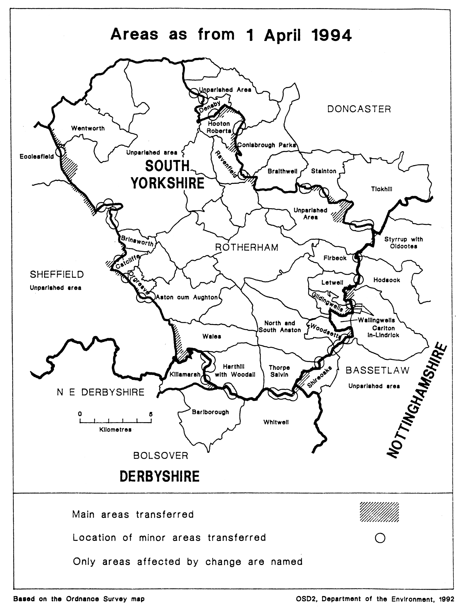
The map and table forming part of this Note (Pages ) give a general guide to the location, area and population of the land affected. Prints of the detailed order maps (described in article 2) may be inspected at all reasonable times at the offices of the council for each district, borough or city affected, and additionally at the offices of the Secretary of State for the Environment located in 2, Marsham Street, London SW1P 3EB.
The Local Government Area Changes Regulations 1976 (S.I. 1976/246, amended by S.I. 1978/247) contain general provisions regarding the effect of orders such as this one.
TABLE DESCRIBING TRANSFERS EFFECTED
| Transfers— | Description— |
|---|---|
| IN ARTICLE 3 Between Derbyshire (Bolsover) and South Yorkshire (Rotherham) Parishes affected: In Bolsover— Barlborough Whitwell In Rotherham— Harthill with Woodall, Thorpe Salvin Transferred from Bolsover— Area: 1 hectare Population: Nil Transferred to Bolsover— Area: 18 hectares Population: Nil | Realignments in vicinity of Whitwell Wood/Southard’s Plantation to follow line of Bondhay Dyke. Minor realignments— (i) in area lying between Whitwell Wood and Whitwell Road; and (ii) in vicinity of Pelleygrove Farm/Birkenhead Wood. Realignment to follow eastern side of Pebley Reservoir. |
| Between Derbyshire (North East Derbyshire) and South Yorkshire (Rotherham) Parishes affected: In North East Derbyshire— Killamarsh In Rotherham— Harthill with Woodall Wales Transferred from North East Derbyshire— Area: 56 hectares Population: Nil Transferred to North East Derbyshire— Area: 22 hectares Population: Nil | Minor realignment on eastern side of Mansfield Road, near Woodall Common. Minor realignments to follow the line of County Dyke at Nor Wood/Killamarsh Pond. Transfer to Rotherham east of railway line at Netherthorpe/Nether Green, including Killamarsh Meadows. Transfer to unite Woodall Common in North East Derbyshire. |
| IN ARTICLE 4 Between Nottinghamshire (Bassetlaw) and South Yorkshire (Rotherham) Parishes affected: In Bassetlaw— Carlton in Lindrick Hodsock Shireoaks Wallingwells Styrrup with Oldcotes In Roterham— Firbeck Gildingwells Letwell North and South Anston Thorpe Salvin Woodsetts Transferred from Bassetlaw— Area: 86 hectares Population: Nil Transferred to Bassetlaw— Area: 155 hectares Population: Nil | Transfer to Bassetlaw of area south of Styrrup Lane, including part of Malpas Hill. Transfer to Bassetlaw of area north-east of Dumb Hall Lane, east of Nether Thrope Road and south of Thorpe Lane, including Shireoaks Park Wood. Realignment in Stonehaven area between Lamb Lane and Maltby Road. Transfer to unite Langold Lake and surroundings in Bassetlaw. Realignments to follow the western side of Owday Lane between Worksop Road and the track leading to Corn Mill Farm. Realignments to the centre of the River Ryton. Realignment to the western side of the A66 road south of Thornbury Hill Lane. Realignment in vicinity of Buckwood Farm. Transfer to Rotherham of— (i) area lying between Buckwood Farm and Wallingwells Lane; (ii) area lying between Owlands Wood Dyke and Owday Lane in vicinity of Corn Mill Farm; and (iii) area lying between Thorpe Lane and Bondhay Dyke. |
| IN ARTICLE 5 Between Doncaster and Rotherham Parishes affected: In Doncaster— Braithwell Conisbrough Parks Denaby Stainton Tickhill In Rotherham— Hooton Roberts Ravenfield Transferred from Doncaster— Area: 270 hectares Population: 30 Transferred to Doncaster— Area: 28 hectares Population: 4 | Transfer to Rotherham of area south of Old Denaby, running from The Fox Well in the west to Hill Top Road in the east. Transfer to Rotherham of area lying to the west of Firsby Lane, including Firsby Reservoir and Firsby Hall Farm. Transfer to Rotherham of area lying between Common Lane and Hellaby Lane, including parts of the M18 motorway, of Bramley Lane and of Braithwell Common. Transfer to Rotherham of area south of Tickhill Road and west of Sandbeck Lane, including Carr House Holt, Carr House, Woolthwaite and part of Woolthwaite Bottoms. Transfer to Rotherham of area west of Folds Lane, including Folds Cottages and woodland to the north of North Walk. Transfer to unite Whitelea Industrial Estate in Doncaster. Transfer to Doncaster of area of open land between Tickhill Road and Scotch Spring Lane. Realignments— (i) to eastern embankment of the Mexborough Curve; (ii) in vicinity of Denaby Lane and The Fox Well; (iii) at Firsby Lane/Sheffield Road/Hill Top; (iv) to southern side of Stainton Lane and western side of Scotch Spring Lane; (v) to centre of River Torne west of Folds Farm and in vicinity of Styrrup Lane. |
| IN ARTICLE 6 Between Rotherham and Sheffield Parishes affected: In Rotherham— Aston cum Aughton Brinsworth Catcliffe Orgreave Wales Wentworth In Sheffield— Ecclesfield Transferred from Rotherham— Area: 124 hectares Population: 88 Transferred to Rotherham— Area: 272 hectares Population. 572 | Transfer to unite Thorpe Hesley in Rotherham, involving transfer of large area east of M1 motorway, stretching from the vicinity of Grange Lane in the south to the vicinity of Hood Hill Farm in the north, and including Hesley Wood, Hesley Hall Farm, London Way, Hesley Barr, Smithy Wood, Lady Clough, Jumble Hole Plantation, Rainstorth Farm, Bluefields and Rainstorth House. Realignments— (i) in vicinity of Retford Road/Woodhouse Hill/St. James Walk; (ii) to western boundary of railway near Woodhouse Mill/Orgrave Lane; (iii) in vicinity of the A630 road and the Europa Link and Wood Lane; (iv) to western side of Sheffield Parkway near Waverley Cottages/High Hazels Park/Tinsley Park Golf Course; (v) to follow line of Chapel Flat Dyke near Highgate/Templeborough Steel Works; (vi) to northern side of railway between Jordans and the M1 motorway; (vii) to the eastern side of the M1 motorway at Blackburn/Grange Lane; and (viii) to eastern side of railway line west of Bedgrave Mill and the river Rother. |
Options/Help
Print Options
PrintThe Whole Instrument
PrintThis Explanatory Note only

Mae deddfwriaeth ar gael mewn fersiynau gwahanol:
Y Diweddaraf sydd Ar Gael (diwygiedig):Y fersiwn ddiweddaraf sydd ar gael o’r ddeddfwriaeth yn cynnwys newidiadau a wnaed gan ddeddfwriaeth ddilynol ac wedi eu gweithredu gan ein tîm golygyddol. Gellir gweld y newidiadau nad ydym wedi eu gweithredu i’r testun eto yn yr ardal ‘Newidiadau i Ddeddfwriaeth’.
Gwreiddiol (Fel y’i Deddfwyd neu y’i Gwnaed): Mae'r wreiddiol fersiwn y ddeddfwriaeth fel ag yr oedd pan gafodd ei deddfu neu eu gwneud. Ni wnaed unrhyw newidiadau i’r testun.
Dewisiadau Agor
Dewisiadau gwahanol i agor deddfwriaeth er mwyn gweld rhagor o gynnwys ar y sgrin ar yr un pryd
Rhagor o Adnoddau
Gallwch wneud defnydd o ddogfennau atodol hanfodol a gwybodaeth ar gyfer yr eitem ddeddfwriaeth o’r tab hwn. Yn ddibynnol ar yr eitem ddeddfwriaeth sydd i’w gweld, gallai hyn gynnwys:
- y PDF print gwreiddiol y fel deddfwyd fersiwn a ddefnyddiwyd am y copi print
- rhestr o newidiadau a wnaed gan a/neu yn effeithio ar yr eitem hon o ddeddfwriaeth
- manylion rhoi grym a newid cyffredinol
- pob fformat o’r holl ddogfennau cysylltiedig
- slipiau cywiro
- dolenni i ddeddfwriaeth gysylltiedig ac adnoddau gwybodaeth eraill
 Mae’r holl gynnwys ar gael dan Drwydded Llywodraeth Agored v3.0 ac eithrio ble nodir yn wahanol. Yn ychwanegol mae’r safle hwn â chynnwys sy’n deillio o EUR-Lex, a ailddefnyddiwyd dan delerau Penderfyniad y Comisiwn 2011/833/EU ar ailddefnyddio dogfennau o sefydliadau’r UE. Am ragor o wybodaeth gweler ddatganiad cyhoeddus Swyddfa Gyhoeddiadau’r UE ar ailddefnyddio.