
ANNEX IU.K.PROHIBITED SPECIES
Species for which there is a prohibition to fish for, retain on board, tranship, land, store, sell, display or offer for sale, as referred to in Article 10(2):
The following species of sawfish in [F1United Kingdom] waters:
narrow sawfish (Anoxypristis cuspidata);
dwarf sawfish (Pristis clavata);
smalltooth sawfish (Pristis pectinata);
largetooth sawfish (Pristis pristis);
green sawfish (Pristis zijsron);
basking shark (Cetorhinus maximus) and white shark (Carcharodon carcharias) in all waters;
smooth lantern shark (Etmopterus pusillus) in [F2United Kingdom] waters of ICES division 2a and subarea 4 and in [F2United Kingdom] waters of ICES subareas [F35, 6, 7 and 8];
reef manta ray (Manta alfredi) in [F4United Kingdom] waters;
giant manta ray (Manta birostris) in [F5United Kingdom] waters;
the following species of Mobula rays in [F6United Kingdom] waters:
devil fish (Mobula mobular);
lesser Guinean devil ray (Mobula rochebrunei);
spinetail mobula (Mobula japanica);
smoothtail mobula (Mobula thurstoni);
longhorned mobula (Mobula eregoodootenkee);
Munk’s devil ray (Mobula munkiana);
Chilean devil ray (Mobula tarapacana);
shortfin devil ray (Mobula kuhlii);
lesser devil ray (Mobula hypostoma);
Norwegian skate (Raja (Dipturus) nidarosiensis) in [F7United Kingdom] waters of ICES divisions 6a, 6b, 7a, F8... 7e, 7f, 7g [F9and 7h];
angel shark (Squatina squatina) in [F14United Kingdom] waters;
salmon (Salmo salar) and sea trout (Salmo trutta) when fishing with any towed net within [F15United Kingdom waters] outside the six-mile limit measured from F16... baselines in ICES sub-areas [F172 and 4–8];
the Adriatic sturgeon (Acipenser naccarii) and common sturgeon (Acipenser sturio) in [F20United Kingdom] waters;
F21. . . . . . . . . . . . . . . . . . . . . . . . . . . . . . . .
F22. . . . . . . . . . . . . . . . . . . . . . . . . . . . . . . .
hatpin urchin (Centrostephanus longispinus).
Textual Amendments
F1Words in Annex 1 point (a) substituted (31.12.2020) by The Common Fisheries Policy and Animals (Amendment etc.) (EU Exit) Regulations 2019 (S.I. 2019/1312), regs. 1(3), 5(31)(a); 2020 c. 1, Sch. 5 para. 1(1)
F2Words in Annex 1 point (c) substituted (31.12.2020) by The Common Fisheries Policy and Animals (Amendment etc.) (EU Exit) Regulations 2019 (S.I. 2019/1312), regs. 1(3), 5(31)(b)(i); 2020 c. 1, Sch. 5 para. 1(1)
F3Words in Annex 1 point (c) substituted (31.12.2020) by The Common Fisheries Policy and Animals (Amendment etc.) (EU Exit) Regulations 2019 (S.I. 2019/1312), regs. 1(3), 5(31)(b)(ii); 2020 c. 1, Sch. 5 para. 1(1)
F4Words in Annex 1 point (d) substituted (31.12.2020) by The Common Fisheries Policy and Animals (Amendment etc.) (EU Exit) Regulations 2019 (S.I. 2019/1312), regs. 1(3), 5(31)(c); 2020 c. 1, Sch. 5 para. 1(1)
F5Words in Annex 1 point (e) substituted (31.12.2020) by The Common Fisheries Policy and Animals (Amendment etc.) (EU Exit) Regulations 2019 (S.I. 2019/1312), regs. 1(3), 5(31)(d); 2020 c. 1, Sch. 5 para. 1(1)
F6Words in Annex 1 point (f) substituted (31.12.2020) by The Common Fisheries Policy and Animals (Amendment etc.) (EU Exit) Regulations 2019 (S.I. 2019/1312), regs. 1(3), 5(31)(e); 2020 c. 1, Sch. 5 para. 1(1)
F7Words in Annex 1 point (g) substituted (31.12.2020) by The Common Fisheries Policy and Animals (Amendment etc.) (EU Exit) Regulations 2019 (S.I. 2019/1312), regs. 1(3), 5(31)(f)(i); 2020 c. 1, Sch. 5 para. 1(1)
F8Words in Annex 1 point (g) omitted (31.12.2020) by virtue of The Common Fisheries Policy and Animals (Amendment etc.) (EU Exit) Regulations 2019 (S.I. 2019/1312), regs. 1(3), 5(31)(f)(ii); 2020 c. 1, Sch. 5 para. 1(1)
F9Words in Annex 1 point (g) substituted (31.12.2020) by The Common Fisheries Policy and Animals (Amendment etc.) (EU Exit) Regulations 2019 (S.I. 2019/1312), regs. 1(3), 5(31)(f)(iii); 2020 c. 1, Sch. 5 para. 1(1)
F10Words in Annex 1 point (h) substituted (31.12.2020) by The Common Fisheries Policy and Animals (Amendment etc.) (EU Exit) Regulations 2019 (S.I. 2019/1312), regs. 1(3), 5(31)(g)(i); 2020 c. 1, Sch. 5 para. 1(1)
F11Words in Annex 1 point (h) substituted (31.12.2020) by The Common Fisheries Policy and Animals (Amendment etc.) (EU Exit) Regulations 2019 (S.I. 2019/1312), regs. 1(3), 5(31)(g)(ii); 2020 c. 1, Sch. 5 para. 1(1)
F12Words in Annex 1 point (i) substituted (31.12.2020) by The Common Fisheries Policy and Animals (Amendment etc.) (EU Exit) Regulations 2019 (S.I. 2019/1312), regs. 1(3), 5(31)(h)(i); 2020 c. 1, Sch. 5 para. 1(1)
F13Words in Annex 1 point (i) substituted (31.12.2020) by The Common Fisheries Policy and Animals (Amendment etc.) (EU Exit) Regulations 2019 (S.I. 2019/1312), regs. 1(3), 5(31)(h)(ii); 2020 c. 1, Sch. 5 para. 1(1)
F14Words in Annex 1 point (j) substituted (31.12.2020) by The Common Fisheries Policy and Animals (Amendment etc.) (EU Exit) Regulations 2019 (S.I. 2019/1312), regs. 1(3), 5(31)(i); 2020 c. 1, Sch. 5 para. 1(1)
F15Words in Annex 1 point (k) substituted (31.12.2020) by The Common Fisheries Policy and Animals (Amendment etc.) (EU Exit) Regulations 2019 (S.I. 2019/1312), regs. 1(3), 5(31)(j)(i); 2020 c. 1, Sch. 5 para. 1(1)
F16Words in Annex 1 point (k) omitted (31.12.2020) by virtue of The Common Fisheries Policy and Animals (Amendment etc.) (EU Exit) Regulations 2019 (S.I. 2019/1312), regs. 1(3), 5(31)(j)(ii); 2020 c. 1, Sch. 5 para. 1(1)
F17Words in Annex 1 point (k) substituted (31.12.2020) by The Common Fisheries Policy and Animals (Amendment etc.) (EU Exit) Regulations 2019 (S.I. 2019/1312), regs. 1(3), 5(31)(j)(iii); 2020 c. 1, Sch. 5 para. 1(1)
F18Words in Annex 1 point (l) inserted (31.12.2020) by The Common Fisheries Policy and Animals (Amendment etc.) (EU Exit) Regulations 2019 (S.I. 2019/1312), regs. 1(3), 5(31)(k)(i); 2020 c. 1, Sch. 5 para. 1(1)
F19Words in Annex 1 point (l) omitted (31.12.2020) by virtue of The Common Fisheries Policy and Animals (Amendment etc.) (EU Exit) Regulations 2019 (S.I. 2019/1312), regs. 1(3), 5(31)(k)(ii); 2020 c. 1, Sch. 5 para. 1(1)
F20Words in Annex 1 point (m) substituted (31.12.2020) by The Common Fisheries Policy and Animals (Amendment etc.) (EU Exit) Regulations 2019 (S.I. 2019/1312), regs. 1(3), 5(31)(l); 2020 c. 1, Sch. 5 para. 1(1)
F21Annex 1 point (n) omitted (31.12.2020) by virtue of The Common Fisheries Policy and Animals (Amendment etc.) (EU Exit) Regulations 2019 (S.I. 2019/1312), regs. 1(3), 5(31)(m); 2020 c. 1, Sch. 5 para. 1(1)
F22Annex 1 point (o) omitted (31.12.2020) by virtue of The Common Fisheries Policy and Animals (Amendment etc.) (EU Exit) Regulations 2019 (S.I. 2019/1312), regs. 1(3), 5(31)(n); 2020 c. 1, Sch. 5 para. 1(1)
ANNEX IIU.K.CLOSED AREAS FOR THE PROTECTION OF SENSITIVE HABITATS
For the purposes of Article 12, the following restrictions on fishing activity are applicable in the areas enclosed by sequentially joining with rhumb lines the following coordinates, which shall be measured according to the WGS84 system:
PART AU.K.North Western Waters
F231.. . . . . . . . . . . . . . . . . . . . . . . . . . . . . . . .U.K.
Textual Amendments
F23Annex 2 Pt. A point 1 omitted (31.12.2020) by virtue of The Common Fisheries Policy and Animals (Amendment etc.) (EU Exit) Regulations 2019 (S.I. 2019/1312), regs. 1(3), 5(32)(a); 2020 c. 1, Sch. 5 para. 1(1)
F242.. . . . . . . . . . . . . . . . . . . . . . . . . . . . . . . .U.K.
Textual Amendments
F24Annex 2 Pt. A point 2 omitted (31.12.2020) by virtue of The Common Fisheries Policy and Animals (Amendment etc.) (EU Exit) Regulations 2019 (S.I. 2019/1312), regs. 1(3), 5(32)(a); 2020 c. 1, Sch. 5 para. 1(1)
3.It shall be prohibited to deploy any bottom trawl or similar towed nets within the following area:U.K.
Darwin Mounds:
59°54′ N, 6°55′ W
59°47′ N, 6°47′ W
59°37′ N, 6°47′ W
59°37′ N, 7°39′ W
59°45′ N, 7°39′ W
59°54′ N, 7°25′ W.
F25PART BU.K.South Western Waters
. . . . . . . . . . . . . . . . . . . . . . . . . . . . . . . .
Textual Amendments
F25Annex 2 Pt. B omitted (31.12.2020) by virtue of The Common Fisheries Policy and Animals (Amendment etc.) (EU Exit) Regulations 2019 (S.I. 2019/1312), regs. 1(3), 5(32)(b); 2020 c. 1, Sch. 5 para. 1(1)
ANNEX IIIU.K. LIST OF SPECIES PROHIBITED FOR CAPTURE WITH DRIFTNETS
Albacore: Thunnus alalunga
Bluefin tuna: Thunnus thynnus
Bigeye tuna: Thunnus obesus
Skipjack: Katsuwonus pelamis
Atlantic Bonito: Sarda sarda
Yellowfin tuna: Thunnus albacares
Blackfin tuna: Thunnus atlanticus
Little tuna: Euthynnus spp.
Southern bluefin tuna: Thunnus maccoyii
Frigate tuna: Auxis spp.
Oceanic sea breams: Brama rayi
Marlins: Tetrapturus spp.; Makaira spp.
Sailfishes: Istiophorus spp.
Swordfishes: Xiphias gladius
Sauries: Scomberesox spp.; Cololabis spp.
Dolphinfishes: Coryphœna spp.
Sharks: Hexanchus griseus; Cetorhinus maximus; Alopiidae; Carcharhinidae; Sphyrnidae; Isuridae; Lamnidae
Cephalopods: all species
F26ANNEX IVU.K.MEASUREMENT OF THE SIZE OF A MARINE ORGANISM
Textual Amendments
The size of any fish shall be measured, as shown in Figure 1, from the tip of the snout to the end of the tail fin.
The size of a Norway lobster (Nephrops norvegicus) shall be measured, as shown in Figure 2, either:
as the length of the carapace, parallel to the midline, from the back of either eye socket to the midpoint of the distal dorsal edge of the carapace, or
as the total length, from the tip of the rostrum to the rear end of the telson, not including the setae.
In the case of detached Norway lobster tails: from the front edge of the first tail segment present to the rear end of the telson, not including the setae. The tail shall be measured flat, unstretched and on the dorsal side.
The size of a lobster (Homarus gammarus) from the North Sea F27... shall be measured, as shown in Figure 3, as the length of the carapace, parallel to the midline, from the back of either eye socket to the distal edge of the carapace [F28(as illustrated in Figure 3 by line “(a)”)].
F29. . . . . . . . . . . . . . . . . . . . . . . . . . . . . . . .
The size of a crawfish (Palinurus spp.) shall be measured, as shown in Figure 4, as the length of the carapace, parallel to the midline, from the tip of the rostrum to the midpoint of the distal dorsal edge of the carapace.
The size of any bivalve mollusc shall be measured, as shown in Figure 5, across the longest part of the shell.
The size of a spinous spider crab (Maja squinado) shall be measured, as shown in Figure 6, as the length of the carapace, along the midline, from the edge of the carapace between the rostrums to the posterior edge of the carapace.
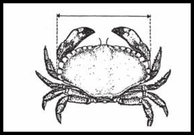
The size of an edible crab (Cancer pagurus) shall be measured, as shown in Figure 7, as the maximum width of the carapace measured perpendicular to the antero-posterior midline of the carapace.
The size of a whelk (Buccinum spp.) shall be measured, as shown in Figure 8, as the length of the shell.
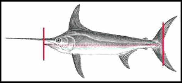
[F30The size of bluefin tuna (Thunnus thynnus) is measured as the projected straight distance between the tip of the snout and the fork of the tail fin (“fork length”) as shown in Figure 10 and labelled as “FL”.]
Textual Amendments
F27Words in Annex 4 point 3 omitted (31.12.2020) by virtue of The Common Fisheries Policy and Animals (Amendment etc.) (EU Exit) Regulations 2019 (S.I. 2019/1312), regs. 1(3), 5(33)(a)(i); 2020 c. 1, Sch. 5 para. 1(1)
F28Words in Annex 4 point 3 inserted (31.12.2020) by The Common Fisheries Policy and Animals (Amendment etc.) (EU Exit) Regulations 2019 (S.I. 2019/1312), regs. 1(3), 5(33)(a)(ii); 2020 c. 1, Sch. 5 para. 1(1)
F29Annex 4 point 4 omitted (31.12.2020) by virtue of The Common Fisheries Policy and Animals (Amendment etc.) (EU Exit) Regulations 2019 (S.I. 2019/1312), regs. 1(3), 5(33)(b); 2020 c. 1, Sch. 5 para. 1(1)
F30Annex 4 point 10 (previously omitted by virtue of S.I. 2019/1312, reg. 5(33)(b)) inserted (1.4.2024) by The Sea Fisheries (International Commission for the Conservation of Atlantic Tunas) (Amendment) Regulations 2024 (S.I. 2024/439), regs. 1(1), 8(2)(a)


ANNEX VU.K.NORTH SEA(1)
PART AU.K.Minimum conservation reference sizes
a In [F31United Kingdom] waters in ICES division 4a. In ICES Divisions 4b and 4c, a minimum conservation reference size of 130 mm shall apply. | |
b In an area in ICES divisions 4b and 4c limited by a point at 53°28′22″ N, 0°09′24″ E, on the coast of England, a straight line joining this point with 53°28′22″ N, 0°22′24″ E, the 6-mile boundary of the United Kingdom, and a straight line connecting a point at 51°54′06″ N, 1°30′30″ E, with a point on the coast of England at 51°55′48″ N, 1°17′00″ E, a minimum conservation reference size of 115 mm shall apply. | |
c For edible crabs caught in pots or creels, a maximum of 1 % by weight of the total catch of edible crab may consist of detached claws. For edible crabs caught with any other fishing gear, a maximum of 75 kg of detached crab claws may be landed. | |
d By way of derogation from Article 15 of Regulation (EU) No 1380/2013, the minimum conservation reference sizes of sardine, anchovy, herring, horse mackerel and mackerel shall not apply within a limit of 10 % by live weight of the total catches retained on board of each of those species. The percentage of sardine, anchovy, herring, horse mackerel or mackerel below minimum conservation reference size shall be calculated as the proportion by live weight of all marine organisms on board after sorting or on landing. The percentage may be calculated on the basis of one or more representative samples. The limit of 10 % shall not be exceeded during transhipment, landing, transportation, storage, display or sale. e [F32For extensions to and exemptions from the minimum conservation reference size (including derogations from Article 15 of Regulation (EU) No 1380/2013 (EUR 2013/1380)), see Article 14 of Regulation (EU) 2016/1627 of the European Parliament and of the Council on a multiannual recovery plan for bluefin tuna in the eastern Atlantic and the Mediterranean Regulation (EUR 2016/1627).] | |
| Species | North Sea |
|---|---|
| Cod (Gadus morhua) | 35 cm |
| Haddock (Melanogrammus aeglefinus) | 30 cm |
| Saithe (Pollachius virens) | 35 cm |
| Pollack (Pollachius pollachius) | 30 cm |
| Hake (Merluccius merluccius) | 27 cm |
| Megrim (Lepidorhombus spp.) | 20 cm |
| Sole (Solea spp.) | 24 cm |
| Plaice (Pleuronectes platessa) | 27 cm |
| Whiting (Merlangius merlangus) | 27 cm |
| Ling (Molva molva) | 63 cm |
| Blue ling (Molva dipterygia) | 70 cm |
| Norway lobster (Nephrops norvegicus) | Total length 85 mm, Carapace length 25 mm Norway lobster tails 46 mm |
| Mackerel (Scomber spp.) | 30 cmd |
| Herring (Clupea harengus) | 20 cmd |
| Horse mackerel (Trachurus spp.) | 15 cmd |
| Anchovy (Engraulis encrasicolus) | 12 cm or 90 individuals per kgd |
| Bass (Dicentrarchus labrax) | 42 cm |
| Sardine (Sardina pilchardus) | 11 cmd |
| Lobster (Homarus gammarus) | 87 mm (carapace length) |
| Spinous spider crab (Maja squinado) | 120 mm |
| Queen scallop (Chalamys spp.) | 40 mm |
| Grooved carpetshell (Ruditapes decussatus) | 40 mm |
| Carpetshell (Venerupis pullastra) | 38 mm |
| Short-necked clam (Venerupis philippinarum) | 35 mm |
| Clam (Venus verrucosa) | 40 mm |
| Hard clam (Callista chione) | 6 cm |
| Razor clam (Ensis spp.) | 10 cm |
| Surf clams (Spisula solida) | 25 mm |
| Donax clams (Donax spp.) | 25 mm |
| Bean solen (Pharus legumen) | 65 mm |
| Whelk (Buccinum undatum.) | 45 mm |
| Octopus (Octopus vulgaris) | 750 g |
| Crawfish (Palinurus spp.) | 95 mm (carapace length) [F33(in the English zone only a minimum conservation reference size of 110 mm shall apply)] |
| Deepwater rose shrimp (Parapenaeus longirostirs) | 22 mm (carapace length) |
| Edible crab (Cancer pagurus) | 140 mma b c |
| Scallop (Pecten maximus) | 100 mm |
| Cod (Gadus morhua) | 30 cm |
| Haddock (Melanogrammus aeglefinus) | 27 cm |
| Saithe (Pollachius virens) | 30 cm |
| Pollack (Pollachius pollachius) | — |
| Hake (Merluccius merluccius) | 30 cm |
| Megrim (Lepidorhombus spp.) | 25 cm |
| Sole (Solea spp.) | 24 cm |
| Plaice (Pleuronectes platessa) | 27 cm |
| Whiting (Merlangius merlangus) | 23 cm |
| Ling (Molva molva) | — |
| Blue ling (Molva dypterygia) | — |
| Norway lobster (Nephrops norvegicus) | Total length 105 mm Norway lobster tails 59 mm Carapace length 32 mm |
| Mackerel (Scomber spp.) | 20 cmd |
| Herring (Clupea harengus) | 18 cmd |
| Horse mackerel (Trachurus spp.) | 15 cmd |
| Lobster (Homarus gammarus) | Total length 220 mm Carapace length 78 mm |
| [F32Bluefin tuna (Thunnus thynnus) | 115 cm or 30 kg]e |
Textual Amendments
F31Words in Annex 5 Pt. A table footnote substituted (31.12.2020) by The Common Fisheries Policy and Animals (Amendment etc.) (EU Exit) Regulations 2019 (S.I. 2019/1312), regs. 1(3), 5(34)(a); 2020 c. 1, Sch. 5 para. 1(1)
F32Words in Annex 5 Pt. A table inserted (1.4.2024) by The Sea Fisheries (International Commission for the Conservation of Atlantic Tunas) (Amendment) Regulations 2024 (S.I. 2024/439), regs. 1(1), 8(3)
F33Words in Annex 5 Pt. A table inserted (16.12.2024) by The Sea Fisheries (Amendment) (No. 2) Regulations 2024 (S.I. 2024/1028), regs. 1(1), 2(3)
PART BU.K.Mesh sizes
1.Baseline mesh sizes for towed gearU.K.
1.1.Without prejudice to the landing obligation, vessels shall use a mesh size of at least 120 mm F34....U.K.Textual Amendments
F34Words in Annex 5 Pt. B point 1.1 omitted (31.12.2020) by The Common Fisheries Policy and Animals (Amendment etc.) (EU Exit) Regulations 2019 (S.I. 2019/1312), regs. 1(3), 5(34)(b)(i) (as substituted by S.I. 2020/1542, regs. 1(2), 17(2)); 2020 c. 1, Sch. 5 para. 1(1)
Textual Amendments
F34Words in Annex 5 Pt. B point 1.1 omitted (31.12.2020) by The Common Fisheries Policy and Animals (Amendment etc.) (EU Exit) Regulations 2019 (S.I. 2019/1312), regs. 1(3), 5(34)(b)(i) (as substituted by S.I. 2020/1542, regs. 1(2), 17(2)); 2020 c. 1, Sch. 5 para. 1(1)
1.2.Without prejudice to the landing obligation,F35... vessels may use smaller mesh sizes as listed in the following table for the North Sea F36... provided that:U.K.
the associated conditions set out in that table are complied with, and by-catches of cod, haddock and saithe do not exceed 20 % of the total catch in live weight of all marine biological resources landed after each fishing trip; or
other selectivity modifications are used which have been [F37authorised by a fisheries administration following scientific assessment and approval]. Those selectivity modifications shall result in the same or better selectivity characteristics for cod, haddock and saithe as that of 120 mm.
Textual Amendments
F37Words in Annex 5 Pt. B point 1.2(ii) substituted (31.12.2020) by The Common Fisheries Policy and Animals (Amendment etc.) (EU Exit) Regulations 2019 (S.I. 2019/1312), regs. 1(3), 5(34)(b)(ii)(cc); 2020 c. 1, Sch. 5 para. 1(1)
Textual Amendments
F35Words in Annex 5 Pt. B point 1.2 omitted (31.12.2020) by virtue of The Common Fisheries Policy and Animals (Amendment etc.) (EU Exit) Regulations 2019 (S.I. 2019/1312), regs. 1(3), 5(34)(b)(ii)(aa); 2020 c. 1, Sch. 5 para. 1(1)
F36Words in Annex 5 Pt. B point 1.2 omitted (31.12.2020) by virtue of The Common Fisheries Policy and Animals (Amendment etc.) (EU Exit) Regulations 2019 (S.I. 2019/1312), regs. 1(3), 5(34)(b)(ii)(bb); 2020 c. 1, Sch. 5 para. 1(1)
a Vessels shall be prohibited from using any beam trawl with a mesh size between 32 and 99 mm north of a line joined by the following points by a point on the East Coast of the United Kingdom at latitude 55° N, then east to latitude 55°, longitude 5° E, then north to latitude 56° N and east to a point on the west coast of Denmark at latitude 56° N. It is prohibited to use any beam trawl of mesh size range 32 to 119 mm within ICES Division 2a and that part of ICES Sub-area 4 to the north of 56° 00′ N. | ||
| Mesh Size | Geographical Areas | Conditions |
|---|---|---|
| At least 100 mma | North Sea south of 57° 30′ N | Directed fishing for plaice and sole with otter trawls, beam trawls, and seines. A square mesh panel of at least 90 mm shall be fitted. |
| At least 80 mma | ICES Divisions 4b and 4c | Directed fishing for sole with beam trawls. A panel with a mesh size of at least 180 mm fitted in the upper half of the anterior part of the net shall be fitted. Directed fishing for whiting, mackerel and species not subject to catch limits with bottom trawls. A square mesh panel of at least 80 mm shall be fitted. |
| At least 80 mm | North Sea | Directed fishing for Norway lobster (Nephrops norvegicus). A square mesh panel of at least 120 mm or sorting grid with a maximum bar spacing of 35 mm or equivalent selectivity device shall be fitted. Directed fishing for species not subject to catch limits and which are not covered elsewhere in the table. A square mesh panel of at least 80 mm shall be fitted. Directed fishing for skates and rays. |
| At least 80 mm | ICES division 4c | Directed fishing for sole using otter trawls. A square mesh panel of at least 80 mm shall be fitted. |
| F38. . . | F38. . . | F38. . . |
| At least 40 mm | Whole area [F39excluding waters within the English zone] | Directed fishing for squid (Lolignidae, Ommastrephidae). |
| F40. . . | F40. . . | F40. . . |
| At least 32 mm | Whole area F41... | Directed fishing for Northern prawn (Pandalus borealis). A sorting grid with a maximum bar spacing of 19 mm or equivalent selectivity device shall be fitted. |
| At least 16 mm | Whole area | Directed fishing for small pelagic species which are not covered elsewhere in the table. Directed fishing for Norway pout. A sorting grid with a maximum bar spacing of 35 mm in the Norway pout fishery shall be fitted. Directed fishing for common and Aesop shrimps. A separator trawl or sorting grid must be fitted in accordance with nationally or regionally established rules. |
| Less than 16 mm | Whole area | Directed fishing for sandeel. |
Textual Amendments
F38Words in Annex 5 Pt. B point 1 table omitted (31.12.2020) by virtue of The Common Fisheries Policy and Animals (Amendment etc.) (EU Exit) Regulations 2019 (S.I. 2019/1312), regs. 1(3), 5(34)(b)(iii)(aa); 2020 c. 1, Sch. 5 para. 1(1)
F39Words in Annex 5 Pt. B point 1 table inserted (24.10.2023) by The Sea Fisheries (Amendment) (England) Regulations 2023 (S.I. 2023/1054), regs. 1(1), 2(3)
F40Words in Annex 5 Pt. B point 1 table omitted (31.12.2020) by virtue of The Common Fisheries Policy and Animals (Amendment etc.) (EU Exit) Regulations 2019 (S.I. 2019/1312), regs. 1(3), 5(34)(b)(iii)(bb); 2020 c. 1, Sch. 5 para. 1(1)
F41Words in Annex 5 Pt. B point 1 table omitted (31.12.2020) by virtue of The Common Fisheries Policy and Animals (Amendment etc.) (EU Exit) Regulations 2019 (S.I. 2019/1312), regs. 1(3), 5(34)(b)(iii)(cc); 2020 c. 1, Sch. 5 para. 1(1)
2.Baseline mesh sizes for static nets and driftnetsU.K.
2.1.Without prejudice to the landing obligation, vessels shall use a mesh size of at least 120 mm.U.K.
2.2.Without prejudice to the landing obligation, and notwithstanding point 2.1, vessels may use smaller mesh sizes as listed in the following table for the North Sea F42... provided that the associated conditions set out in that table are complied with and by-catches of cod, haddock and saithe do not exceed 20 % of the total catch in live weight of all marine biological resources landed after each fishing trip.U.K.Textual Amendments
F42Words in Annex 5 Pt. B point 2.2 omitted (31.12.2020) by virtue of The Common Fisheries Policy and Animals (Amendment etc.) (EU Exit) Regulations 2019 (S.I. 2019/1312), regs. 1(3), 5(34)(b)(iv); 2020 c. 1, Sch. 5 para. 1(1)
Textual Amendments
F42Words in Annex 5 Pt. B point 2.2 omitted (31.12.2020) by virtue of The Common Fisheries Policy and Animals (Amendment etc.) (EU Exit) Regulations 2019 (S.I. 2019/1312), regs. 1(3), 5(34)(b)(iv); 2020 c. 1, Sch. 5 para. 1(1)
| Mesh Size | Geographical Areas | Conditions |
|---|---|---|
| At least 100 mm | Whole area | Directed fishing for haddock, whiting, dab and bass |
| At least 90 mm | Whole area | Directed fishing for flatfish or species not subject to catch limits and which are not covered elsewhere in the table |
| At least 50 mm | Whole area | Directed fishing for small pelagic species which are not covered elsewhere in the table |
PART CU.K.Closed or restricted areas
1.Closure of an area to protect sandeel in ICES divisions 4a and 4bU.K.
1.1.Fishing for sandeel with any towed gear with a codend mesh size less than 32 mm shall be prohibited within the geographical area bounded by the east coast of England and Scotland, and enclosed by sequentially joining with rhumb lines the following coordinates, which shall be measured according to the WGS84 system:U.K.
the east coast of England at latitude 55°30′ N
55°30′ N, 01°00′ W
58°00′ N, 01°00′ W
58°00′ N, 02°00′ W
the east coast of Scotland at longitude 02°00′ W.
1.2.Fisheries for scientific investigation shall be allowed in order to monitor the sandeel stock in the area and the effects of the closure.U.K.
F432.. . . . . . . . . . . . . . . . . . . . . . . . . . . . . . . .U.K.
Textual Amendments
F43Annex 5 Pt. C point 2 omitted (31.12.2020) by virtue of The Common Fisheries Policy and Animals (Amendment etc.) (EU Exit) Regulations 2019 (S.I. 2019/1312), regs. 1(3), 5(34)(c)(i); 2020 c. 1, Sch. 5 para. 1(1)
3.Restrictions on the use of beam trawls within 12 nautical miles of the coast of the United KingdomU.K.
3.1.Vessels shall be prohibited from using any beam trawl inside the areas within 12 nautical miles of the coast of the United Kingdom, measured from the baselines of the territorial waters.U.K.
3.2.By way of derogation from point 3.1, fishing with beam trawls within the specified area shall be permitted provided that:U.K.
The engine power of the vessels does not exceed 221 Kw and their overall length does not exceed 24 m; and
The beam length or aggregated beam length, measured as the sum of each beam, is no more than 9 m, or cannot be extended to a length greater than 9 m, except when directed fishing for common shrimp (Crangon crangon) with a minimum mesh size of less than 31 mm.
4.Restrictions on fishing for sprat to protect herring in ICES division 4bU.K.
Fishing with any towed gear with a codend mesh size of less than 32 mm or static nets less than 30 mm mesh size shall be prohibited within the geographical areas enclosed by sequentially joining with rhumb lines the following coordinates, which shall be measured according to the WGS84, and during the following periods mentioned:
from 1 January to 31 March, and from 1 October to 31 December, within ICES statistical area 39E8. For the purpose of this Regulation, that ICES area shall be the area bounded by a line due east from the east coast of the United Kingdom along latitude 55°00′ N to a point at longitude 1°00′ W, from there due north to a point at latitude 55°30′ N and from there due west to the United Kingdom coast;
from 1 January to 31 March, and from 1 October to 31 December, within the inner waters of the Moray Firth west of longitude 3°30′ W, and in the inner waters of the Firth of Forth west of longitude 3°00′ W,
F44...
Textual Amendments
F44Words in Annex 5 Pt. C point 4 omitted (31.12.2020) by virtue of The Common Fisheries Policy and Animals (Amendment etc.) (EU Exit) Regulations 2019 (S.I. 2019/1312), regs. 1(3), 5(34)(c)(ii); 2020 c. 1, Sch. 5 para. 1(1)
F455.. . . . . . . . . . . . . . . . . . . . . . . . . . . . . . . .U.K.
Textual Amendments
F45Annex 5 Pt. C point 5 omitted (31.12.2020) by virtue of The Common Fisheries Policy and Animals (Amendment etc.) (EU Exit) Regulations 2019 (S.I. 2019/1312), regs. 1(3), 5(34)(c)(iii); 2020 c. 1, Sch. 5 para. 1(1)
6.Use of static nets in ICES [F46division 4a] U.K.
6.1.In accordance with point (a) of Article 9(7) and by way of derogation from Part B Point 2 of this Annex, it shall be permitted to use the following gear in waters with a charted depth of less than 600 m:U.K.
Bottom set gillnets used for directed fishing for hake of a mesh size of at least 100 mm and no more than 100 meshes deep, where the total length of all nets deployed does not exceed 25 km per vessel and the maximum soak time is 24 hours;
Entangling nets used for directed fishing for anglerfish of a mesh size of at least 250 mm and no more than 15 meshes deep, where the total length of all nets deployed does not exceed 100 km and the maximum soak time is 72 hours.
6.2.Directed fishing for deepwater sharks as listed in Annex I to Regulation (EU) 2016/2336 of the European Parliament and of the Council(2) in charted depths of less than 600 m shall be prohibited. When accidentally caught, deepwater sharks classified as prohibited in this Regulation and other F47... legislation shall be recorded, unharmed to the extent possible, and shall be promptly released. Deepwater sharks subject to catch limits shall be retained on board. Such catches shall be landed and counted against quotas. F48... Where accidental catches of deepwater sharks by [F49United Kingdom fishing vessels] exceed 10 tonnes then those vessels may no longer avail of the derogations set out in point 6.1.U.K.Textual Amendments
F47Word in Annex 5 Pt. C point 6.2 omitted (31.12.2020) by virtue of The Common Fisheries Policy and Animals (Amendment etc.) (EU Exit) Regulations 2019 (S.I. 2019/1312), regs. 1(3), 5(34)(c)(v)(aa); 2020 c. 1, Sch. 5 para. 1(1)
F48Words in Annex 5 Pt. C point 6.2 omitted (31.12.2020) by virtue of The Common Fisheries Policy and Animals (Amendment etc.) (EU Exit) Regulations 2019 (S.I. 2019/1312), regs. 1(3), 5(34)(c)(v)(bb); 2020 c. 1, Sch. 5 para. 1(1)
F49Words in Annex 5 Pt. C point 6.2 substituted (31.12.2020) by The Common Fisheries Policy and Animals (Amendment etc.) (EU Exit) Regulations 2019 (S.I. 2019/1312), regs. 1(3), 5(34)(c)(v)(cc); 2020 c. 1, Sch. 5 para. 1(1)
Textual Amendments
F46Words in Annex 5 Pt. C point 6 substituted (31.12.2020) by The Common Fisheries Policy and Animals (Amendment etc.) (EU Exit) Regulations 2019 (S.I. 2019/1312), regs. 1(3), 5(34)(c)(iv); 2020 c. 1, Sch. 5 para. 1(1)
PART DU.K.The use of electric pulse trawls in ICES divisions 4b and 4c
1.Fishing with electric pulse trawl shall be prohibited in all [F50United Kingdom] waters as of 1 July 2021.U.K.Textual Amendments
F50Words in Annex 5 Pt. D point 1 substituted (31.12.2020) by The Common Fisheries Policy and Animals (Amendment etc.) (EU Exit) Regulations 2019 (S.I. 2019/1312), regs. 1(3), 5(34)(d)(i); 2020 c. 1, Sch. 5 para. 1(1)
Textual Amendments
F50Words in Annex 5 Pt. D point 1 substituted (31.12.2020) by The Common Fisheries Policy and Animals (Amendment etc.) (EU Exit) Regulations 2019 (S.I. 2019/1312), regs. 1(3), 5(34)(d)(i); 2020 c. 1, Sch. 5 para. 1(1)
2.During the transitional period ending 30 June 2021, [F51a fisheries administration may authorise United Kingdom fishing vessels to fish] with electric pulse trawl in ICES divisions 4b and 4c F52... under the conditions set out in this [F53Part] and any conditions defined in [F54regulations made under Article 24 of this Regulation for the purpose specified in paragraph 4(b) of that Article], regarding the characteristics of the pulse used and control monitoring measures in place [F55in United Kingdom waters of the area] south of a rhumb line joined by the following points, which shall be measured according to the WGS84 coordinate system:U.K.
a point on east coast of the United Kingdom at latitude 55° N
east to latitude 55° N, longitude 5° E
north to latitude 56° N
east to a point on the west coast of Denmark at latitude 56° N.
The following conditions shall apply:
no more than 5 % of [F56all the beam trawlers in the United Kingdom fleet] use the electric pulse trawl;
the maximum electrical power in kW for each beam trawl is no more than the length in metres of the beam multiplied by 1,25;
the effective voltage between the electrodes is no more than 15 V;
the vessel is equipped with an automatic computer management system which records the maximum power used per beam and the effective voltage between electrodes for at least the last 100 tows. It is not possible for non-authorised personnel to modify this automatic computer management system;
it is prohibited to use one or more tickler chains in front of the footrope.
Textual Amendments
F56Words in Annex 5 Pt. D point 2(a) substituted (31.12.2020) by The Common Fisheries Policy and Animals (Amendment etc.) (EU Exit) Regulations 2019 (S.I. 2019/1312), regs. 1(3), 5(34)(d)(ii)(ff); 2020 c. 1, Sch. 5 para. 1(1)
Textual Amendments
F51Words in Annex 5 Pt. D point 2 substituted (31.12.2020) by The Common Fisheries Policy and Animals (Amendment etc.) (EU Exit) Regulations 2019 (S.I. 2019/1312), regs. 1(3), 5(34)(d)(ii)(aa); 2020 c. 1, Sch. 5 para. 1(1)
F52Words in Annex 5 Pt. D point 2 omitted (31.12.2020) by virtue of The Common Fisheries Policy and Animals (Amendment etc.) (EU Exit) Regulations 2019 (S.I. 2019/1312), regs. 1(3), 5(34)(d)(ii)(bb); 2020 c. 1, Sch. 5 para. 1(1)
F53Word in Annex 5 Pt. D point 2 inserted (31.12.2020) by The Common Fisheries Policy and Animals (Amendment etc.) (EU Exit) Regulations 2019 (S.I. 2019/1312), regs. 1(3), 5(34)(d)(ii)(cc); 2020 c. 1, Sch. 5 para. 1(1)
F54Words in Annex 5 Pt. D point 2 substituted (31.12.2020) by The Common Fisheries Policy and Animals (Amendment etc.) (EU Exit) Regulations 2019 (S.I. 2019/1312), regs. 1(3), 5(34)(d)(ii)(dd); 2020 c. 1, Sch. 5 para. 1(1)
F55Words in Annex 5 Pt. D point 2 inserted (31.12.2020) by The Common Fisheries Policy and Animals (Amendment etc.) (EU Exit) Regulations 2019 (S.I. 2019/1312), regs. 1(3), 5(34)(d)(ii)(ee); 2020 c. 1, Sch. 5 para. 1(1)
3.New licences shall not be granted to any vessel during this period.U.K.
F574.. . . . . . . . . . . . . . . . . . . . . . . . . . . . . . . .U.K.
Textual Amendments
F57Annex 5 Pt. D point 4 omitted (31.12.2020) by virtue of The Common Fisheries Policy and Animals (Amendment etc.) (EU Exit) Regulations 2019 (S.I. 2019/1312), regs. 1(3), 5(34)(d)(iii); 2020 c. 1, Sch. 5 para. 1(1)
F585.. . . . . . . . . . . . . . . . . . . . . . . . . . . . . . . .U.K.
Textual Amendments
F58Annex 5 Pt. D point 5 omitted (31.12.2020) by virtue of The Common Fisheries Policy and Animals (Amendment etc.) (EU Exit) Regulations 2019 (S.I. 2019/1312), regs. 1(3), 5(34)(d)(iii); 2020 c. 1, Sch. 5 para. 1(1)
ANNEX VIU.K.NORTH WESTERN WATERS
PART AU.K.
Minimum conservation reference sizes
a In ICES divisions 6a and 7a a minimum conservation reference size of total length of 70 mm and a carapace length of 20 mm shall apply. | |
b In ICES divisions 6a and 7a a minimum conservation reference size of 37 mm shall apply. | |
c In [F59United Kingdom] waters in ICES sub-areas, 5, 6 south of 56° N and 7, except ICES divisions 7d, 7e and 7f, a minimum conservation reference size of 130 mm shall apply. | |
d For edible crabs caught in pots or creels, a maximum of 1 % by weight of the total catch of edible crab may consist of detached claws. For edible crabs caught with any other fishing gear, a maximum of 75 kg of detached crab claws may be landed. | |
e In ICES division 7a north of 52°30′ N, and ICES division 7d, a minimum conservation reference size of 110 mm shall apply. | |
f By way of derogation from Article 15 of Regulation (EU) No 1380/2013, the minimum conservation reference sizes of sardine, anchovy, herring, horse mackerel and mackerel shall not apply within a limit of 10 % by live weight of the total catches retained on board of each of those species. g [F60For extensions to and exemptions from the minimum conservation reference size (including derogations from Article 15 of Regulation (EU) No 1380/2013 (EUR 2013/1380)), see Article 14 of Regulation (EU) 2016/1627 of the European Parliament and of the Council on a multiannual recovery plan for bluefin tuna in the eastern Atlantic and the Mediterranean Regulation (EUR 2016/1627).] | |
| Species | Whole area [F61(unless otherwise specified)] |
|---|---|
| Cod (Gadus morhua) | 35 cm |
| Haddock (Melanogrammus aeglefinus) | 30 cm |
| Saithe (Pollachius virens) | 35 cm |
| Pollack (Pollachius pollachius) | 30 cm |
| Hake (Merluccius merluccius) | 27 cm |
| Megrim (Lepidorhombus spp.) | 20 cm |
| Sole (Solea spp.) | 24 cm |
| Plaice (Pleuronectes platessa) | 27 cm |
| Whiting (Merlangius merlangus) | 27 cm |
| Ling (Molva molva) | 63 cm |
| Blue ling (Molva dypterygia) | 70 cm |
| Norway lobster (Nephrops norvegicus) Norway Lobster tails | Total length 85 mm, Carapace length 25 mma 46 mmb |
| Mackerel (Scomber spp.) | 20 cmf |
| Herring (Clupea harengus) | 20 cmf |
| Horse mackerel (Trachurus spp.) | 15 cmf |
| Anchovy (Engraulis encrasicolus) | 12 cm or 90 individuals per kgf |
| Bass (Dicentrarchus labrax) | 42 cm |
| Sardine (Sardina pilchardus) | 11 cmf |
| Red sea-bream (Pagellus bogaraveo) | 33 cm |
| Lobster (Hommarus gammarus) | 87 mm |
| Spinous spider crab (Maja squinado) | 120 mm |
| Queen scallop (Chlamys spp.) | 40 mm |
| Grooved carpetshell (Ruditapes decussatus) | 40 mm |
| Carpetshell (Venerupis pullastra) | 38 mm |
| Short-necked clam (Venerupis philippinarum) | 35 mm |
| Clam (Venus verrucosa) | 40 mm |
| Hard clam (Callista chione) | 6 cm |
| Razor clam (Ensis spp.) | 10 cm |
| Surf clams (Spisula solida) | 25 mm |
| Donax clams (Donax spp.) | 25 mm |
| Bean solen (Pharus legumen) | 65 mm |
| Whelk (Buccinum undatum.) | 45 mm |
| Octopus (Octopus vulgaris) | 750 g |
| Crawfish (Palinurus spp.) | 95 mm [F62(in the English zone only a minimum conservation reference size of 110 mm shall apply)] |
| Deepwater rose shrimp (Parapenaeus longirostris) | 22 mm (carapace length) |
| Edible crab (Cancer pagurus) | 140 mmc d |
| Scallop (Pecten maximus) | 100 mme |
| [F60Bluefin tuna (Thunnus thynnus) | 115 cm or 30 kg]g |
| [F63Lemon Sole (Microstomus kitt) | 25cm applicable in ICES divisions 7d and 7e only |
| Turbot (Scophthalmus maximus) | 30cm applicable in ICES divisions 7d and 7e only |
| Brill (Scophthalmus rhombus) | 30cm applicable in ICES divisions 7d and 7e only] |
Textual Amendments
F59Words in Annex 6 Pt. A table footnote substituted (31.12.2020) by The Common Fisheries Policy and Animals (Amendment etc.) (EU Exit) Regulations 2019 (S.I. 2019/1312), regs. 1(3), 5(35)(a); 2020 c. 1, Sch. 5 para. 1(1)
F60Words in Annex 6 Pt. A table inserted (1.4.2024) by The Sea Fisheries (International Commission for the Conservation of Atlantic Tunas) (Amendment) Regulations 2024 (S.I. 2024/439), regs. 1(1), 8(4)
F61Words in Annex 6 Pt. A table inserted (16.12.2024) by The Sea Fisheries (Amendment) (No. 2) Regulations 2024 (S.I. 2024/1028), regs. 1(1), 2(4)(a)
F62Words in Annex 6 Pt. A table inserted (16.12.2024) by The Sea Fisheries (Amendment) (No. 2) Regulations 2024 (S.I. 2024/1028), regs. 1(1), 2(4)(b)
F63Words in Annex 6 Pt. A table inserted (16.12.2024) by The Sea Fisheries (Amendment) (No. 2) Regulations 2024 (S.I. 2024/1028), regs. 1(1), 2(4)(c)
The percentage of sardine, anchovy, herring, horse mackerel or mackerel below the minimum conservation reference size shall be calculated as the proportion by live weight of all marine organisms on board after sorting or on landing.
The percentage may be calculated on the basis of one or more representative samples. The limit of 10 % shall not be exceeded during transhipment, landing, transportation, storage, display or sale.
PART BU.K.Mesh sizes
1.Baseline mesh sizes for towed gearU.K.
1.1.Without prejudice to the landing obligation, vessels shall use a mesh size of at least 120 mm(3), or at least 100 mm in ICES sub-area [F647d–7j].U.K.Textual Amendments
F64Words in Annex 6 Pt. B point 1.1 substituted (31.12.2020) by The Common Fisheries Policy and Animals (Amendment etc.) (EU Exit) Regulations 2019 (S.I. 2019/1312), regs. 1(3), 5(35)(b)(i); 2020 c. 1, Sch. 5 para. 1(1)
Textual Amendments
F64Words in Annex 6 Pt. B point 1.1 substituted (31.12.2020) by The Common Fisheries Policy and Animals (Amendment etc.) (EU Exit) Regulations 2019 (S.I. 2019/1312), regs. 1(3), 5(35)(b)(i); 2020 c. 1, Sch. 5 para. 1(1)
1.2.Without prejudice to the landing obligation, and notwithstanding point 1.1, vessels may use smaller mesh sizes as listed in the following table for the North Western waters provided that:U.K.
the associated conditions set out in that table are complied with, and by-catches of cod, haddock and saithe do not exceed 20 % of the total catch in live weight of all marine biological resources landed after each fishing trip; or
other selectivity modifications are used which have been [F65authorised by a fisheries administration following scientific assessment and approval]. Those selectivity modifications shall result in the same or better selectivity characteristics for cod, haddock and saithe as that of 120 mm, or 100 mm in ICES sub-area [F667d]-7k, respectively.
Textual Amendments
F65Words in Annex 6 Pt. B point 1.2(ii) substituted (31.12.2020) by The Common Fisheries Policy and Animals (Amendment etc.) (EU Exit) Regulations 2019 (S.I. 2019/1312), regs. 1(3), 5(35)(b)(ii)(aa); 2020 c. 1, Sch. 5 para. 1(1)
F66Word in Annex 6 Pt. B point 1.2(ii) substituted (31.12.2020) by The Common Fisheries Policy and Animals (Amendment etc.) (EU Exit) Regulations 2019 (S.I. 2019/1312), regs. 1(3), 5(35)(b)(ii)(bb); 2020 c. 1, Sch. 5 para. 1(1)
a This is without prejudice to Article 5 of Commission Regulation (EC) No 494/2002f. | ||
b At least 70 mm mesh size shall apply for single rig vessels in ICES division 7a. | ||
c This is without prejudice to Article 2(5) of Commission Implementing Regulation (EU) No 737/2012g. | ||
d This provision shall not apply to ICES division 7d. | ||
e This provision shall not apply when directed fishing for whiting, mackerel and species not subject to catch limits in ICES divisions 7d and 7e. | ||
f Commission Regulation (EC) No 494/2002 of 19 March 2002 establishing additional technical measures for the recovery of the stock of hake in ICES sub-areas III, IV, V, VI and VII and ICES divisions VIII a, b, d, e (OJ L 77, 20.3.2002, p. 8). | ||
g Commission Implementing Regulation (EU) No 737/2012 of 14 August 2012 on the protection of certain stocks in the Celtic Sea (OJ L 218, 15.8.2012, p. 8). | ||
| Mesh Size | Geographical Areas | Conditions |
|---|---|---|
| At least 80 mma | ICES sub-area 7 | Directed fishing for hake, megrim and anglerfish, or directed fishing for whiting, mackerel and species not subject to catch limits and which are not covered elsewhere in the table, using bottom trawls. A square mesh panel of at least 120 mm shall be fittedce Directed fishing for sole and species not covered by catch limits, using otter trawls. A square mesh panel of at least 80 mm shall be fittedc. |
| At least 80 mm | Whole area | Directed fishing for Norway lobster (Nephrops norvegicus)b. A square mesh panel of at least 120 mm or sorting grid with a maximum bar spacing of 35 mm or equivalent selectivity device shall be fitted. |
| At least 80 mm | ICES divisions 7a, F67... 7d, 7e, 7f, 7g, 7h and 7j | Directed fishing for sole with beam trawls. A panel with a mesh size of at least 180 mmd fitted in the upper half of the anterior part of the net shall be fitted. |
| At least 80 mm | ICES divisions 7d and 7e | Directed fishing for whiting, mackerel and species not subject to catch limits and which are not covered elsewhere in the table, using bottom trawls. |
| At least 40 mm | Whole area [F68excluding waters within the English zone] | Directed fishing for squid (Lolignidae, Ommastrephidae) |
| At least 16 mm | Whole area | Directed fishing for small pelagic species which are not covered elsewhere in the table. Directed fishing for common and Aesop shrimps. A separator trawl or sorting grid must be fitted in accordance with nationally established rules |
| Less than 16 mm | Whole area | Directed fishing for sandeel |
| [F69At least 100mm | ICES divisions 7d and 7e | Directed fishing for all species using flyseining gear] |
Textual Amendments
F67Word in Annex 6 Pt. B point 1 table omitted (31.12.2020) by virtue of The Common Fisheries Policy and Animals (Amendment etc.) (EU Exit) Regulations 2019 (S.I. 2019/1312), regs. 1(3), 5(35)(b)(iii); 2020 c. 1, Sch. 5 para. 1(1)
F68Words in Annex 6 Pt. B point 1 table inserted (24.10.2023) by The Sea Fisheries (Amendment) (England) Regulations 2023 (S.I. 2023/1054), regs. 1(1), 2(4)
F69Words in Annex 6 Pt. B point 1 table inserted (16.12.2024) by The Sea Fisheries (Amendment) (No. 2) Regulations 2024 (S.I. 2024/1028), regs. 1(1), 2(5)
2.Baseline mesh sizes for static nets and driftnetsU.K.
2.1.Without prejudice to the landing obligation, vessels shall use a mesh size of at least 120 mm(4).U.K.
2.2.Without prejudice to the landing obligation, and notwithstanding point 2.1, vessels may use smaller mesh sizes as listed in the following table for the North Western waters provided that the associated conditions set out in that table are complied with, and by-catches of cod, haddock and saithe do not exceed 20 % of the total catch in live weight of all marine biological resources landed after each fishing trip.U.K.
a In division 7d, [F70with the exception of directed fishing for bass,] at least 90 mm shall apply. | ||
| Mesh Size | Geographical Areas | Conditions |
|---|---|---|
| At least 100 mma | Whole area | Directed fishing for flatfish or species not subject to catch limits and which are not covered elsewhere in the table Directed fishing for whiting, dab and bass |
| At least 50 mm | Whole area | Directed fishing for small pelagic species which are not covered elsewhere in the table Directed fishing for red mullet |
Textual Amendments
F70Words in Annex 6 Pt. B point 2 table footnote inserted (31.12.2021) by The Sea Fisheries (Amendment etc.) (No. 2) Regulations 2021 (S.I. 2021/1429), regs. 1(1), 7(2)
3.This Part is without prejudice to Commission Delegated Regulation (EU) 2018/2034(5), for the fisheries covered by that Delegated Regulation.U.K.
PART CU.K.Closed or restricted areas
1.Closed area for the conservation of cod in ICES division 6aU.K.
From 1 January to 31 March, and from 1 October to 31 December, each year, it shall be prohibited to conduct any fishing activity using any towed gear or static nets in the area enclosed by sequentially joining with rhumb lines the following coordinates, which shall be measured according to the WGS84 coordinate system:
55°25′ N, 7°07′ W
55°25′ N, 7°00′ W
55°18′ N, 6°50′ W
55°17′ N, 6°50′ W
55°17′ N, 6°52′ W
55°25′ N, 7°07 W.
2.Closed area for the conservation of cod in ICES divisions 7f and 7gU.K.
2.1.From 1 February to 31 March each year, it shall be prohibited to conduct any fishing activity in the following ICES statistical rectangles: 30E4, 31E4 [F71and United Kingdom waters of] 32E3. This prohibition shall not apply within 6 nautical miles from the baseline.U.K.Textual Amendments
F71Words in Annex 6 Pt. C point 2.1 substituted (31.12.2020) by The Common Fisheries Policy and Animals (Amendment etc.) (EU Exit) Regulations 2019 (S.I. 2019/1312), regs. 1(3), 5(35)(c)(i); 2020 c. 1, Sch. 5 para. 1(1)
Textual Amendments
F71Words in Annex 6 Pt. C point 2.1 substituted (31.12.2020) by The Common Fisheries Policy and Animals (Amendment etc.) (EU Exit) Regulations 2019 (S.I. 2019/1312), regs. 1(3), 5(35)(c)(i); 2020 c. 1, Sch. 5 para. 1(1)
2.2.
It shall be permitted to conduct fishing activities using pots and creels within the specified areas and time periods, provided that:
no fishing gear other than pots and creels are carried on board; and
by-catches of a species subject to the landing obligation are landed and counted against quotas.
2.3.Directed fishing for small pelagic species with towed gear with a mesh size less than 55 mm shall be permitted, provided that:U.K.
no net of mesh size greater than or equal to 55 mm is carried on board; and
by-catches of a species subject to the landing obligation are landed and counted against quotas.
3.Closed area for the conservation of cod in ICES division 7aU.K.
3.1.
In the period from 14 February to 30 April each year it shall be prohibited to use any dermersal trawl, seine or similar towed net, any gillnet, entangling net or trammel net or any fishing gear incorporating hooks [F72in United Kingdom waters] within that part of ICES division 7a enclosed by the east coast of Ireland and the east coast of Northern Ireland and straight lines sequentially joining the following geographical coordinates, which shall be measured according to the WGS84 coordinate system:
a point on the east coast of the Ards peninsula in Northern Ireland at 54°30′ N
54°30′ N, 04°50′ W
53°15′ N, 04°50′ W
a point on the east coast of Ireland at 53°15′ N.
Textual Amendments
F72Words in Annex 6 Pt. C point 3.1 inserted (31.12.2020) by The Common Fisheries Policy and Animals (Amendment etc.) (EU Exit) Regulations 2019 (S.I. 2019/1312), regs. 1(3), 5(35)(c)(ii); 2020 c. 1, Sch. 5 para. 1(1)
3.2.By way of derogation from point 1, within the area and time period referred to therein the use of demersal trawls shall be permitted provided such trawls are fitted with selective devices that have been [F73approved by a fisheries administration following scientific assessment and approval].U.K.Textual Amendments
F73Words in Annex 6 Pt. C point 3.2 substituted (31.12.2020) by The Common Fisheries Policy and Animals (Amendment etc.) (EU Exit) Regulations 2019 (S.I. 2019/1312), regs. 1(3), 5(35)(c)(iii); 2020 c. 1, Sch. 5 para. 1(1)
Textual Amendments
F73Words in Annex 6 Pt. C point 3.2 substituted (31.12.2020) by The Common Fisheries Policy and Animals (Amendment etc.) (EU Exit) Regulations 2019 (S.I. 2019/1312), regs. 1(3), 5(35)(c)(iii); 2020 c. 1, Sch. 5 para. 1(1)
4.Rockall haddock box in ICES sub-area 6U.K.
All fishing, except with longlines, shall be prohibited in [F74United Kingdom waters of] the areas enclosed by sequentially joining with rhumb lines the following coordinates, which shall be measured according to the WGS84 system:
Textual Amendments
F74Words in Annex 6 Pt. C point 4 inserted (31.12.2020) by The Common Fisheries Policy and Animals (Amendment etc.) (EU Exit) Regulations 2019 (S.I. 2019/1312), regs. 1(3), 5(35)(c)(iv); 2020 c. 1, Sch. 5 para. 1(1)
57°00′ N, 15°00′ W
57°00′ N, 14°00′ W
56°30′ N, 14°00′ W
56°30′ N, 15°00′ W
57°00′ N, 15°00′ W.
F755.. . . . . . . . . . . . . . . . . . . . . . . . . . . . . . . .U.K.
Textual Amendments
F75Annex 6 Pt. C point 5 omitted (31.12.2020) by virtue of The Common Fisheries Policy and Animals (Amendment etc.) (EU Exit) Regulations 2019 (S.I. 2019/1312), regs. 1(3), 5(35)(c)(v); 2020 c. 1, Sch. 5 para. 1(1)
6.Special rules for the protection of blue ling in ICES division 6aU.K.
6.1.From 1 March to 31 May each year directed fishing for blue ling shall be prohibited in the areas of ICES division 6a enclosed by sequentially joining with rhumb lines the following coordinates, which shall be measured according to the WGS84 system:U.K.
Edge of Scottish continental shelf
59°58′ N, 07°00′ W
59°55′ N, 06°47′ W
59°51′ N, 06°28′ W
59°45′ N, 06°38′ W
59°27′ N, 06°42′ W
59°22′ N, 06°47′ W
59°15′ N, 07°15′ W
59°07′ N, 07°31′ W
58°52′ N, 07°44′ W
58°44′ N, 08°11′ W
58°43′ N, 08°27′ W
58°28′ N, 09°16′ W
58°15′ N, 09°32′ W
58°15′ N, 09°45′ W
58°30′ N, 09°45′ W
59°30′ N, 07°00′ W
59°58′ N, 07°00′ W
Edge of Rosemary bank
60°00′ N, 11°00′ W
59°00′ N, 11°00′ W
59°00′ N, 09°00′ W
59°30′ N, 09°00′ W
59°30′ N, 10°00′ W
60°00′ N, 10°00′ W
60°00′ N, 11°00′ W
Not including the area enclosed by sequentially joining with rhumb lines the following coordinates, which shall be measured according to the WGS84 system:
59°15′ N, 10°24′ W
59°10′ N, 10°22′ W
59°08′ N, 10°07′ W
59°11′ N, 09°59′ W
59°15′ N, 09°58′ W
59°22′ N, 10°02′ W
59°23′ N, 10°11′ W
59°20′ N, 10°19′ W
59°15′ N, 10°24′ W.
6.2.A by-catch of blue ling up to a threshold of 6 tonnes may be retained on board and landed. Once a vessel reaches this six-tonne threshold of blue ling:U.K.
it shall immediately cease fishing and exit the area in which it is present;
it may not re-enter either of the areas until its catch has been landed;
it may not return to the sea any quantity of blue ling.
F766.3.. . . . . . . . . . . . . . . . . . . . . . . . . . . . . . . .U.K.
Textual Amendments
F76Annex 6 Pt. C point 6.3 omitted (31.12.2020) by virtue of The Common Fisheries Policy and Animals (Amendment etc.) (EU Exit) Regulations 2019 (S.I. 2019/1312), regs. 1(3), 5(35)(c)(vi); 2020 c. 1, Sch. 5 para. 1(1)
7.Restrictions on fishing for mackerel in ICES divisions 7e, 7f, 7g and 7hU.K.
7.1.Directed fishing for mackerel with towed gear with a codend mesh size of less than 80 mm or with purse seines shall be prohibited, except where the weight of the mackerel does not exceed 15 % by live weight of the total quantities of mackerel and other marine organisms on board which have been caught, [F77in United Kingdom waters] within the area enclosed by sequentially joining with rhumb lines the following coordinates, which shall be measured according to the WGS84 system:U.K.
a point on the south coast of the United Kingdom at 02°00′ W
49° 30′ N, 2° 00′ W
49° 30′ N, 7° 00′ W
52° 00′ N, 7° 00′ W
a point on the west coast of the United Kingdom at 52° 00′ N.
Textual Amendments
F77Words in Annex 6 Pt. C point 7.1 inserted (31.12.2020) by The Common Fisheries Policy and Animals (Amendment etc.) (EU Exit) Regulations 2019 (S.I. 2019/1312), regs. 1(3), 5(35)(c)(vii); 2020 c. 1, Sch. 5 para. 1(1)
7.2.It shall be permitted to fish within the area defined in point 7.1 with:U.K.
static nets and/or hand lines;
demersal trawls, Danish seines or other similar towed nets, with a mesh size greater than 80 mm.
7.3.Vessels which are not equipped for fishing and to which mackerel are being transhipped shall be permitted within the area defined in point 7.1.U.K.
8.Restrictions on the use of beam trawls within 12 nautical miles of the coast of the United Kingdom F78...U.K.
8.1.The use of any beam trawl of mesh size less than 100 mm shall be prohibited in ICES division 5b and ICES sub-area 6 north of latitude 56°N.U.K.
8.2.Vessels shall be prohibited from using any beam trawl inside the areas within 12 nautical miles of the coasts of the United Kingdom F79..., measured from the baselines from which the territorial waters are measured.U.K.Textual Amendments
F79Words in Annex 6 Pt. C point 8.2 omitted (31.12.2020) by virtue of The Common Fisheries Policy and Animals (Amendment etc.) (EU Exit) Regulations 2019 (S.I. 2019/1312), regs. 1(3), 5(35)(c)(ix); 2020 c. 1, Sch. 5 para. 1(1)
Textual Amendments
F79Words in Annex 6 Pt. C point 8.2 omitted (31.12.2020) by virtue of The Common Fisheries Policy and Animals (Amendment etc.) (EU Exit) Regulations 2019 (S.I. 2019/1312), regs. 1(3), 5(35)(c)(ix); 2020 c. 1, Sch. 5 para. 1(1)
8.3.Fishing with beam trawls within the specified area shall be permitted provided that:U.K.
The engine power of the vessels does not exceed 221 Kw and their length does not exceed 24 m; and
The beam length or aggregated beam length, measured as the sum of each beam, is no more than 9 m, or cannot be extended to a length greater than 9 m, except when directed fishing for common shrimp (Crangon crangon) with a codend mesh size of less than 31 mm.
Textual Amendments
F78Words in Annex 6 Pt. C point 8 omitted (31.12.2020) by virtue of The Common Fisheries Policy and Animals (Amendment etc.) (EU Exit) Regulations 2019 (S.I. 2019/1312), regs. 1(3), 5(35)(c)(viii); 2020 c. 1, Sch. 5 para. 1(1)
9.Use of static nets in ICES divisions 5b, 6a, 6b, F80... 7h [F81and 7j] U.K.
9.1.In accordance with point (a) of Article 9(7) and by way of derogation from Part B, Point 2 of this Annex, it shall be permitted to use the following gear in waters with a charted depth of less than 600 m:U.K.
Bottom set gillnets used for directed fishing for hake with a mesh size of at least 100 mm and no more than 100 meshes deep, where the total length of all nets deployed does not exceed 25 km per vessel and the maximum soak time is 24 hours.
Entangling nets used for directed fishing for anglerfish with a mesh size of at least 250 mm and no more than 15 meshes deep, where the total length of all nets deployed does not exceed 100 km and the maximum soak time is 72 hours.
9.2.Directed fishing for deepwater sharks as listed in Annex I to Regulation (EU) 2016/2336 in charted depths of less than 600 m shall be prohibited. When accidentally caught, deepwater sharks classified as prohibited in this Regulation and other F82... legislation shall be recorded, unharmed to the extent possible, and shall be promptly released. Deepwater sharks subject to catch limits shall be retained on board. Such catches shall be landed and counted against quotas. F83... Where accidental catches of deepwater sharks by [F84United Kingdom fishing vessels] exceed 10 tonnes then those vessels may no longer avail of the derogations set out in point 9.1.U.K.Textual Amendments
F82Word in Annex 6 Pt. C point 9.2 omitted (31.12.2020) by virtue of The Common Fisheries Policy and Animals (Amendment etc.) (EU Exit) Regulations 2019 (S.I. 2019/1312), regs. 1(3), 5(35)(c)(xi)(aa); 2020 c. 1, Sch. 5 para. 1(1)
F83Words in Annex 6 Pt. C point 9.2 omitted (31.12.2020) by virtue of The Common Fisheries Policy and Animals (Amendment etc.) (EU Exit) Regulations 2019 (S.I. 2019/1312), regs. 1(3), 5(35)(c)(xi)(bb); 2020 c. 1, Sch. 5 para. 1(1)
F84Words in Annex 6 Pt. C point 9.2 substituted (31.12.2020) by The Common Fisheries Policy and Animals (Amendment etc.) (EU Exit) Regulations 2019 (S.I. 2019/1312), regs. 1(3), 5(35)(c)(xi)(cc); 2020 c. 1, Sch. 5 para. 1(1)
Textual Amendments
F80Words in Annex 6 Pt. C point 9 omitted (31.12.2020) by virtue of The Common Fisheries Policy and Animals (Amendment etc.) (EU Exit) Regulations 2019 (S.I. 2019/1312), regs. 1(3), 5(35)(c)(x)(aa); 2020 c. 1, Sch. 5 para. 1(1)
F81Words in Annex 6 Pt. C point 9 substituted (31.12.2020) by The Common Fisheries Policy and Animals (Amendment etc.) (EU Exit) Regulations 2019 (S.I. 2019/1312), regs. 1(3), 5(35)(c)(x)(bb); 2020 c. 1, Sch. 5 para. 1(1)
[F8510.Restrictions on the engine power of vessels using flyseining gear within 12 nautical miles of the coast of the United Kingdom in ICES divisions 7d and 7eU.K.
Vessels are prohibited from using flyseining gear within 12 nautical miles of the coast of the United Kingdom in ICES divisions 7d and 7e, measured from the baselines from which the territorial waters are measured, unless the engine power of the vessels does not exceed 221 kW.]
Textual Amendments
F85Annex 6 Pt. C point 10 inserted (16.12.2024) by The Sea Fisheries (Amendment) (No. 2) Regulations 2024 (S.I. 2024/1028), regs. 1(1), 2(6)
ANNEX VIIU.K.SOUTH WESTERN WATERS
PART AU.K.Minimum conservation reference sizes
a F86. . . | |
b F86. . . | |
c F86. . . | |
e For edible crabs caught in pots or creels, a maximum of 1 % by weight of the total catch of edible crab may consist of detached claws. For edible crabs caught with any other fishing gear, a maximum of 75 kg of detached crab claws may be landed. | |
f By way of derogation from Article 15 of Regulation (EU) No 1380/2013, the minimum conservation reference sizes of sardine, anchovy, herring, horse mackerel and mackerel shall not apply within a limit of 10 % by live weight of the total catches retained on board of each of those species. The percentage of sardine, anchovy, herring, horse mackerel or mackerel below the minimum conservation reference size shall be calculated as the proportion by live weight of all marine organisms on board after sorting or on landing. The percentage may be calculated on the basis of one or more representative samples. The limit of 10 % shall not be exceeded during transhipment, landing, transportation, storage, display or sale. | |
g No more than 5 % may consist of horse mackerel between 12 and 15 cm. For the purposes of the control of that quantity, the conversion factor to be applied to the weight of the catches shall be 1,20. These provisions shall not apply for catches subject to the landing obligation. h [F89For extensions to and exemptions from the minimum conservation reference size (including derogations from Article 15 of Regulation (EU) No 1380/2013 (EUR 2013/1380)), see Article 14 of Regulation (EU) 2016/1627 of the European Parliament and of the Council on a multiannual recovery plan for bluefin tuna in the eastern Atlantic and the Mediterranean Regulation (EUR 2016/1627).] | |
| Species | Whole area |
|---|---|
| Cod (Gadus morhua) | 35 cm |
| Haddock (Melanogrammus aeglefinus) | 30 cm |
| Saithe (Pollachius virens) | 35 cm |
| Pollack (Pollachius pollachius) | 30 cm |
| Hake (Merluccius merluccius) | 27 cm |
| Megrim (Lepidorhombus spp.) | 20 cm |
| Sole (Solea spp.) | 24 cm |
| Plaice (Pleuronectes platessa) | 27 cm |
| Whiting (Merlangius merlangus) | 27 cm |
| Ling (Molva molva) | 63 cm |
| Blue ling (Molva dypterygia) | 70 cm |
| Norway lobster (Nephrops norvegicus) | Total length 70 mm, Carapace length 20 mm |
| Norway Lobster tails | 37 mm |
| Mackerel (Scomber spp.) | 20 cmf |
| Herring (Clupea harengus) | 20 cmf |
| Horse mackerel (Trachurus spp.) | 15 cm F86. . . f g |
| Anchovy (Engraulis encrasicolus) | 12 cm or 90 individuals per kg F86. . . f |
| Bass (Dicentrarchus labrax) | 36 cm |
| Sardine (Sardina pilchardus) | 11 cmf |
| Red sea-bream (Pagellus bogaraveo) | 33 cm |
| Lobster (Hommarus gammarus) | 87 mm |
| Spinous spider crab (Maja squinado) | 120 mm |
| Queen scallop (Chlamys spp.) | 40 mm |
| Grooved carpetshell (Ruditapes decussatus) | 40 mm |
| Carpetshell (Venerupis pullastra) | 38 mm |
| Short-necked clam (Venerupis philippinarum) | 35 mm |
| Clam (Venus verrucosa) | 40 mm |
| Hard clam (Callista chione) | 6 cm |
| Razor clam (Ensis spp.) | 10 cm |
| Surf clams (Spisula solida) | 25 mm |
| Donax clams (Donax spp.) | 25 mm |
| Bean solen (Pharus legumen) | 65 mm |
| Whelk (Buccinum undatum.) | 45 mm |
| Octopus (Octopus vulgaris) | 750 g F86. . . |
| Crawfish (Palinurus spp.) | [F90110] mm |
| Deepwater rose shrimp (Parapenaeus longirostris) | 22 mm (carapace length) |
| Edible crab (Cancer pagurus) | 140 mmd e |
| Scallop (Pecten maximus) | 100 mm |
| [F89Bluefin tuna (Thunnus thynnus) | 115 cm or 30 kg]h |
Textual Amendments
F86Annex 7 Pt. A table footnotes omitted (31.12.2020) by virtue of The Common Fisheries Policy and Animals (Amendment etc.) (EU Exit) Regulations 2019 (S.I. 2019/1312), regs. 1(3), 5(36)(a)(i); 2020 c. 1, Sch. 5 para. 1(1)
F87Words in Annex 7 Pt. A table footnote substituted (31.12.2020) by The Common Fisheries Policy and Animals (Amendment etc.) (EU Exit) Regulations 2019 (S.I. 2019/1312), regs. 1(3), 5(36)(a)(ii)(aa); 2020 c. 1, Sch. 5 para. 1(1)
F88Words in Annex 7 Pt. A table footnote substituted (31.12.2020) by The Common Fisheries Policy and Animals (Amendment etc.) (EU Exit) Regulations 2019 (S.I. 2019/1312), regs. 1(3), 5(36)(a)(ii)(bb); 2020 c. 1, Sch. 5 para. 1(1)
F89Words in Annex 7 Pt. A table inserted (1.4.2024) by The Sea Fisheries (International Commission for the Conservation of Atlantic Tunas) (Amendment) Regulations 2024 (S.I. 2024/439), regs. 1(1), 8(5)
F90Word in Annex 7 Pt. A table substituted (16.12.2024) by The Sea Fisheries (Amendment) (No. 2) Regulations 2024 (S.I. 2024/1028), regs. 1(1), 2(7)
PART BU.K.Mesh sizes
1.Baseline mesh sizes for towed gearU.K.
1.1.Without prejudice to the landing obligation, vessels shall use a mesh size of at least 70 mm(6)M1F91...U.K.Textual Amendments
F91Words in Annex 7 Pt. B point 1.1 omitted (31.12.2020) by virtue of The Common Fisheries Policy and Animals (Amendment etc.) (EU Exit) Regulations 2019 (S.I. 2019/1312), regs. 1(3), 5(36)(b)(i); 2020 c. 1, Sch. 5 para. 1(1)
Marginal Citations
M1For directed fishing for Norway lobster (Nephrops norvegicus), a square mesh panel of at least 100 mm or equivalent selectivity device shall be fitted when fishing in ICES [division 8d]. For directed fishing for sole with beam trawls, a panel with a mesh size of at least 180 mm fitted in the upper half of the anterior part of the net shall be fitted. [Editorial note: Words in Annex 7 Pt. B point 1.1 footnote substituted (31.12.2020) by virtue of The Common Fisheries Policy and Animals (Amendment etc.) (EU Exit) Regulations 2019 (S.I. 2019/1312), regs. 1(3), 5(36)(b)(iii)(cc); 2020 c. 1, Sch. 5 para. 1(1)]
Textual Amendments
F91Words in Annex 7 Pt. B point 1.1 omitted (31.12.2020) by virtue of The Common Fisheries Policy and Animals (Amendment etc.) (EU Exit) Regulations 2019 (S.I. 2019/1312), regs. 1(3), 5(36)(b)(i); 2020 c. 1, Sch. 5 para. 1(1)
Marginal Citations
M1For directed fishing for Norway lobster (Nephrops norvegicus), a square mesh panel of at least 100 mm or equivalent selectivity device shall be fitted when fishing in ICES [division 8d]. For directed fishing for sole with beam trawls, a panel with a mesh size of at least 180 mm fitted in the upper half of the anterior part of the net shall be fitted. [Editorial note: Words in Annex 7 Pt. B point 1.1 footnote substituted (31.12.2020) by virtue of The Common Fisheries Policy and Animals (Amendment etc.) (EU Exit) Regulations 2019 (S.I. 2019/1312), regs. 1(3), 5(36)(b)(iii)(cc); 2020 c. 1, Sch. 5 para. 1(1)]
1.2.Without prejudice to the landing obligation and notwithstanding point 2.1, vessels may use smaller mesh sizes as listed in the following table for South Western waters provided that:U.K.
the associated conditions set out in that table are complied with, and by-catches of hake do not exceed 20 % of the total catch in live weight of all marine biological resources landed after each fishing trip; or
Textual Amendments
F92Words in Annex 7 Pt. B point 1.2(ii) substituted (31.12.2020) by The Common Fisheries Policy and Animals (Amendment etc.) (EU Exit) Regulations 2019 (S.I. 2019/1312), regs. 1(3), 5(36)(b)(ii)(aa); 2020 c. 1, Sch. 5 para. 1(1)
F93Words in Annex 7 Pt. B point 1.2(ii) omitted (31.12.2020) by virtue of The Common Fisheries Policy and Animals (Amendment etc.) (EU Exit) Regulations 2019 (S.I. 2019/1312), regs. 1(3), 5(36)(b)(ii)(bb); 2020 c. 1, Sch. 5 para. 1(1)
| Mesh Size | Geographical Areas | Conditions |
|---|---|---|
| At least 55mm | Whole area F94... | Directed fishing for species not subject to catch limits and which are not covered elsewhere in the table Directed fishing for red sea bream Directed fishing for mackerel, horse mackerel and blue whiting with bottom trawls |
| At least 35mm | Whole area | Directed fishing for wedge sole |
| F95. . . | F95. . . | F95. . . |
| At least 16 mm | Whole area | Directed fishing for small pelagic species which are not covered elsewhere in the table Directed fishing for shrimps (Palaemon serratus, Crangon crangon), and crab (Polybius henslowi) |
| Less than 16 mm | Whole area | Directed fishing for sandeel |
Textual Amendments
F94Words in Annex 7 Pt. B point 1 table omitted (31.12.2020) by virtue of The Common Fisheries Policy and Animals (Amendment etc.) (EU Exit) Regulations 2019 (S.I. 2019/1312), regs. 1(3), 5(36)(b)(iii)(aa); 2020 c. 1, Sch. 5 para. 1(1)
F95Words in Annex 7 Pt. B point 1 table omitted (31.12.2020) by virtue of The Common Fisheries Policy and Animals (Amendment etc.) (EU Exit) Regulations 2019 (S.I. 2019/1312), regs. 1(3), 5(36)(b)(iii)(bb); 2020 c. 1, Sch. 5 para. 1(1)
2.Baseline mesh sizes for static nets and driftnetsU.K.
2.1.Without prejudice to the landing obligation, vessels shall use a mesh size of at least 100 mm(7)F96...U.K.Textual Amendments
F96Words in Annex 7 Pt. B point 2.1 omitted (31.12.2020) by virtue of The Common Fisheries Policy and Animals (Amendment etc.) (EU Exit) Regulations 2019 (S.I. 2019/1312), regs. 1(3), 5(36)(b)(iv); 2020 c. 1, Sch. 5 para. 1(1)
Textual Amendments
F96Words in Annex 7 Pt. B point 2.1 omitted (31.12.2020) by virtue of The Common Fisheries Policy and Animals (Amendment etc.) (EU Exit) Regulations 2019 (S.I. 2019/1312), regs. 1(3), 5(36)(b)(iv); 2020 c. 1, Sch. 5 para. 1(1)
2.2.Without prejudice to the landing obligation, and notwithstanding point 2.1, vessels may use smaller mesh sizes as listed in the following table for the South Western waters provided that the associated conditions set out in that table are complied with, and by-catches of hake do not exceed 20 % of the total catch in live weight of all marine biological resources landed after each fishing trip.U.K.
a A mesh size of less than 40 mm may be used for sardines. | ||
| Mesh Size | Geographical Areas | Conditions |
|---|---|---|
| At least 80 mm | Whole area F97... | Directed fishing for sea bass, whiting, turbot, flounder and pollack |
| At least 60 mm | Whole area | Directed fishing for species not subject to catch limits and which are not covered elsewhere in the table |
| At least 50 mm | Whole area | Directed fishing for small pelagic speciesa which are not covered elsewhere in the table |
| At least 40 mm | Whole area | Directed fishing for red mullet, shrimps (Penaeus spp.), mantis shrimp, wedge sole and wrasse |
Textual Amendments
F97Words in Annex 7 Pt. B point 2 table omitted (31.12.2020) by virtue of The Common Fisheries Policy and Animals (Amendment etc.) (EU Exit) Regulations 2019 (S.I. 2019/1312), regs. 1(3), 5(36)(b)(v); 2020 c. 1, Sch. 5 para. 1(1)
PART CU.K.Closed or restricted areas
F981.. . . . . . . . . . . . . . . . . . . . . . . . . . . . . . . . U.K.
Textual Amendments
F98Annex 7 Pt. C point 1 omitted (31.12.2020) by virtue of The Common Fisheries Policy and Animals (Amendment etc.) (EU Exit) Regulations 2019 (S.I. 2019/1312), regs. 1(3), 5(36)(c)(i); 2020 c. 1, Sch. 5 para. 1(1)
F992.. . . . . . . . . . . . . . . . . . . . . . . . . . . . . . . . U.K.
Textual Amendments
F99Annex 7 Pt. C point 2 omitted (31.12.2020) by virtue of The Common Fisheries Policy and Animals (Amendment etc.) (EU Exit) Regulations 2019 (S.I. 2019/1312), regs. 1(3), 5(36)(c)(i); 2020 c. 1, Sch. 5 para. 1(1)
F1003.. . . . . . . . . . . . . . . . . . . . . . . . . . . . . . . . U.K.
Textual Amendments
F100Annex 7 Pt. C point 3 omitted (31.12.2020) by virtue of The Common Fisheries Policy and Animals (Amendment etc.) (EU Exit) Regulations 2019 (S.I. 2019/1312), regs. 1(3), 5(36)(c)(i); 2020 c. 1, Sch. 5 para. 1(1)
4.Use of static nets in [F101United Kingdom waters of ICES division 8d] U.K.
4.1.In accordance with point (a) of Article 9(7) and by way of derogation from Part B, Point 2 of this Annex, it shall be permitted to use the following gear in waters with a charted depth of less than 600 m:U.K.
Bottom set gillnets used for directed fishing for hake of a mesh size of at least [F102100mm in United Kingdom waters of ICES division 8d] and no more than 100 meshes deep, where the total length of all nets deployed does not exceed 25 km per vessel and the maximum soak time is 24 hours.
Entangling nets used for directed fishing for anglerfish of a mesh size of at least 250 mm and no more than 15 meshes deep, where the total length of all nets deployed does not exceed 100 km and the maximum soak time is 72 hours.
F103...
Textual Amendments
F102Words in Annex 7 Pt. C point 4.1 substituted (31.12.2020) by The Common Fisheries Policy and Animals (Amendment etc.) (EU Exit) Regulations 2019 (S.I. 2019/1312), regs. 1(3), 5(36)(c)(iii)(aa); 2020 c. 1, Sch. 5 para. 1(1)
F103Words in Annex 7 Pt. C point 4.1 omitted (31.12.2020) by virtue of The Common Fisheries Policy and Animals (Amendment etc.) (EU Exit) Regulations 2019 (S.I. 2019/1312), regs. 1(3), 5(36)(c)(iii)(bb); 2020 c. 1, Sch. 5 para. 1(1)
4.2.Directed fishing for deepwater sharks as listed in Annex I to Regulation (EU) 2016/2336 in charted depths of less than 600 m shall be prohibited. When accidentally caught, deepwater sharks classified as prohibited in this Regulation and other F104... legislation shall be recorded, unharmed to the extent possible, and shall be promptly released. Deepwater sharks subject to catch limits shall be retained on board. Such catches shall be landed and counted against quotas. F105... Where accidental catches of deepwater sharks by [F106United Kingdom fishing vessels] exceed 10 tonnes then those vessels may no longer avail of the derogations set out in point 4.1.U.K.Textual Amendments
F104Word in Annex 7 Pt. C point 4.2 omitted (31.12.2020) by virtue of The Common Fisheries Policy and Animals (Amendment etc.) (EU Exit) Regulations 2019 (S.I. 2019/1312), regs. 1(3), 5(36)(c)(iv)(aa); 2020 c. 1, Sch. 5 para. 1(1)
F105Words in Annex 7 Pt. C point 4.2 omitted (31.12.2020) by virtue of The Common Fisheries Policy and Animals (Amendment etc.) (EU Exit) Regulations 2019 (S.I. 2019/1312), regs. 1(3), 5(36)(c)(iv)(bb); 2020 c. 1, Sch. 5 para. 1(1)
F106Words in Annex 7 Pt. C point 4.2 substituted (31.12.2020) by The Common Fisheries Policy and Animals (Amendment etc.) (EU Exit) Regulations 2019 (S.I. 2019/1312), regs. 1(3), 5(36)(c)(iv)(cc); 2020 c. 1, Sch. 5 para. 1(1)
Textual Amendments
F104Word in Annex 7 Pt. C point 4.2 omitted (31.12.2020) by virtue of The Common Fisheries Policy and Animals (Amendment etc.) (EU Exit) Regulations 2019 (S.I. 2019/1312), regs. 1(3), 5(36)(c)(iv)(aa); 2020 c. 1, Sch. 5 para. 1(1)
F105Words in Annex 7 Pt. C point 4.2 omitted (31.12.2020) by virtue of The Common Fisheries Policy and Animals (Amendment etc.) (EU Exit) Regulations 2019 (S.I. 2019/1312), regs. 1(3), 5(36)(c)(iv)(bb); 2020 c. 1, Sch. 5 para. 1(1)
F106Words in Annex 7 Pt. C point 4.2 substituted (31.12.2020) by The Common Fisheries Policy and Animals (Amendment etc.) (EU Exit) Regulations 2019 (S.I. 2019/1312), regs. 1(3), 5(36)(c)(iv)(cc); 2020 c. 1, Sch. 5 para. 1(1)
F1074.3.. . . . . . . . . . . . . . . . . . . . . . . . . . . . . . . . U.K.
Textual Amendments
F107Annex 7 Pt. C point 4.3 omitted (31.12.2020) by virtue of The Common Fisheries Policy and Animals (Amendment etc.) (EU Exit) Regulations 2019 (S.I. 2019/1312), regs. 1(3), 5(36)(c)(v); 2020 c. 1, Sch. 5 para. 1(1)
Textual Amendments
F101Words in Annex 7 Pt. C point 4 substituted (31.12.2020) by The Common Fisheries Policy and Animals (Amendment etc.) (EU Exit) Regulations 2019 (S.I. 2019/1312), regs. 1(3), 5(36)(c)(ii); 2020 c. 1, Sch. 5 para. 1(1)
F108ANNEX VIIIU.K.BALTIC SEA
. . . . . . . . . . . . . . . . . . . . . . . . . . . . . . . .
Textual Amendments
F108Annexes 8-11 omitted (31.12.2020) by virtue of The Common Fisheries Policy and Animals (Amendment etc.) (EU Exit) Regulations 2019 (S.I. 2019/1312), regs. 1(3), 5(37); 2020 c. 1, Sch. 5 para. 1(1)
F108ANNEX IXU.K.MEDITERRANEAN SEA
. . . . . . . . . . . . . . . . . . . . . . . . . . . . . . . .
F108ANNEX XU.K.BLACK SEA
. . . . . . . . . . . . . . . . . . . . . . . . . . . . . . . .
F108ANNEX XIU.K.UNION WATERS IN THE INDIAN OCEAN AND THE WEST ATLANTIC
. . . . . . . . . . . . . . . . . . . . . . . . . . . . . . . .
ANNEX XIIU.K. NEAFC REGULATORY AREA
PART AU.K. Minimum conservation reference sizes
| Species | NEAFC |
|---|---|
| Haddock (Melanogrammus aeglefinus) | 30 cm |
| Ling (Molva molva) | 63 cm |
| Blue ling (Molva dipterygia) | 70 cm |
| Mackerel (Scomber spp.) | 30 cm |
| Herring (Clupea harengus) | 20 cm |
PART BU.K. Mesh sizes
1.Baseline mesh sizes for towed gearU.K.
The following codend mesh sizes shall apply in the NEAFC Regulatory Area.
| Codend Mesh Size | Geographical Areas | Conditions |
|---|---|---|
| At least 100 mm | Whole area | None |
| At least 35 mm | Whole area | Directed fishing for blue whiting |
| At least 32 mm | ICES sub-areas 1 and 2 | Directed fishing for Northern prawn (Pandalus borealis). A sorting grid with a maximum bar spacing of 22 shall be fitted |
| At least 16 mm | Whole area | Directed fishing for mackerel, capelin and argentines |
2.Baseline mesh sizes for static netsU.K.
The following mesh sizes for static nets shall apply in the NEAFC Regulatory Area.
| Mesh Size | Geographical Areas | Conditions |
|---|---|---|
| At least 220 mm | Whole area | None |
PART CU.K.Closed or restricted areas
1.Measures for the redfish fishery in the Irminger Sea and adjacent watersU.K.
1.1.It shall be prohibited to catch redfish in international waters of ICES sub-area 5 F109....U.K.
By way of derogation from the first subparagraph, it shall be permitted to catch redfish from 11 May to 31 December in the area enclosed by sequentially joining with rhumb lines the following coordinates, which shall be measured according to the WGS84 system (the ‘Redfish Conservation Area’):
64°45′ N, 28°30′ W
62°50′ N, 25°45′ W
61°55′ N, 26°45′ W
61°00′ N, 26°30′ W
59°00′ N, 30°00′ W
59°00′ N, 34°00′ W
61°30′ N, 34°00′ W
62°50′ N, 36°00′ W
64°45′ N, 28°30′ W.
Textual Amendments
F109Words in Annex 12 Pt. C point 1.1 omitted (31.12.2020) by virtue of The Common Fisheries Policy and Animals (Amendment etc.) (EU Exit) Regulations 2019 (S.I. 2019/1312), regs. 1(3), 5(38)(a)(i); 2020 c. 1, Sch. 5 para. 1(1)
1.2.Notwithstanding point 1.1, a fishery for redfish may be permitted, by [F110regulations made by a fisheries administration], outside the Redfish Conservation Area in the Irminger Sea and adjacent waters from 11 May to 31 December each year on the basis of scientific advice and provided that NEAFC has established a recovery plan in respect of redfish in that geographical area. Only [F111United Kingdom vessels] that have been duly authorised by [F112a fisheries administration] and notified F113... as required under Article 5 of Regulation (EU) No 1236/2010 shall participate in this fishery.U.K.Textual Amendments
F110Words in Annex 12 Pt. C point 1.2 substituted (31.12.2020) by The Common Fisheries Policy and Animals (Amendment etc.) (EU Exit) Regulations 2019 (S.I. 2019/1312), regs. 1(3), 5(38)(a)(ii)(aa); 2020 c. 1, Sch. 5 para. 1(1)
F111Words in Annex 12 Pt. C point 1.2 substituted (31.12.2020) by The Common Fisheries Policy and Animals (Amendment etc.) (EU Exit) Regulations 2019 (S.I. 2019/1312), regs. 1(3), 5(38)(a)(ii)(bb); 2020 c. 1, Sch. 5 para. 1(1)
F112Words in Annex 12 Pt. C point 1.2 substituted (31.12.2020) by The Common Fisheries Policy and Animals (Amendment etc.) (EU Exit) Regulations 2019 (S.I. 2019/1312), regs. 1(3), 5(38)(a)(ii)(cc); 2020 c. 1, Sch. 5 para. 1(1)
F113Words in Annex 12 Pt. C point 1.2 omitted (31.12.2020) by virtue of The Common Fisheries Policy and Animals (Amendment etc.) (EU Exit) Regulations 2019 (S.I. 2019/1312), regs. 1(3), 5(38)(a)(ii)(dd); 2020 c. 1, Sch. 5 para. 1(1)
Textual Amendments
F110Words in Annex 12 Pt. C point 1.2 substituted (31.12.2020) by The Common Fisheries Policy and Animals (Amendment etc.) (EU Exit) Regulations 2019 (S.I. 2019/1312), regs. 1(3), 5(38)(a)(ii)(aa); 2020 c. 1, Sch. 5 para. 1(1)
F111Words in Annex 12 Pt. C point 1.2 substituted (31.12.2020) by The Common Fisheries Policy and Animals (Amendment etc.) (EU Exit) Regulations 2019 (S.I. 2019/1312), regs. 1(3), 5(38)(a)(ii)(bb); 2020 c. 1, Sch. 5 para. 1(1)
F112Words in Annex 12 Pt. C point 1.2 substituted (31.12.2020) by The Common Fisheries Policy and Animals (Amendment etc.) (EU Exit) Regulations 2019 (S.I. 2019/1312), regs. 1(3), 5(38)(a)(ii)(cc); 2020 c. 1, Sch. 5 para. 1(1)
F113Words in Annex 12 Pt. C point 1.2 omitted (31.12.2020) by virtue of The Common Fisheries Policy and Animals (Amendment etc.) (EU Exit) Regulations 2019 (S.I. 2019/1312), regs. 1(3), 5(38)(a)(ii)(dd); 2020 c. 1, Sch. 5 para. 1(1)
1.3.It shall be prohibited to use trawls with a mesh size of less than 100 mm.U.K.
1.4.The conversion factor to be applied to the gutted and headed presentation, including the Japanese cut presentation, of redfish caught in this fishery shall be 1,70.U.K.
1.5.Masters of fishing vessels engaged in the fishery outside the Redfish Conservation Area shall transmit the catch report provided for in point (b) of Article 9(1) of Regulation (EU) No 1236/2010 on a daily basis after the fishing operations of that calendar day have been completed. It shall indicate the catches on board taken since the last communication of catches.U.K.
1.6.In addition to Article 5 of Regulation (EU) No 1236/2010, an authorisation to fish for redfish shall only be valid if the reports transmitted by vessels are in accordance with Article 9(1) of that Regulation and are recorded in accordance with Article 9(3) thereof.U.K.
1.7.The reports referred to in point 1.6 shall be made in accordance with the relevant rules.U.K.
2.Special rules for the protection of blue lingU.K.
2.1.From 1 March to 31 May each year it shall be prohibited to retain on board any quantity of blue ling in excess of 6 tonnes per fishing trip in the areas of ICES division 6a enclosed by sequentially joining with rhumb lines the following coordinates, which shall be measured according to the WGS84 system:U.K.
Edge of Scottish continental shelf
59°58′ N, 07°00′ W
59°55′ N, 06°47′ W
59°51′ N, 06°28′ W
59°45′ N, 06°38′ W
59°27′ N, 06°42′ W
59°22′ N, 06°47′ W
59°15′ N, 07°15′ W
59°07′ N, 07°31′ W
58°52′ N, 07°44′ W
58°44′ N, 08°11′ W
58°43′ N, 08°27′ W
58°28′ N, 09°16′ W
58°15′ N, 09°32′ W
58°15′ N, 09°45′ W
58°30′ N, 09°45′ W
59°30′ N, 07°00′ W
59°58′ N, 07°00′ W;
Edge of Rosemary bank
60°00′ N, 11°00′ W
59°00′ N, 11°00′ W
59°00′ N, 09°00′ W
59°30′ N, 09°00′ W
59°30′ N, 10°00′ W
60°00′ N, 10°00′ W
60°00′ N, 11°00′ W
Not including the area enclosed by sequentially joining with rhumb lines the following coordinates, which shall be measured according to the WGS84 system:
59°15′ N, 10°24′ W
59°10′ N, 10°22′ W
59°08′ N, 10°07′ W
59°11′ N, 09°59′ W
59°15′ N, 09°58′ W
59°22′ N, 10°02′ W
59°23′ N, 10°11′ W
59°20′ N, 10°19′ W
59°15′ N, 10°24′ W.
2.2.Where blue ling is subject to the landing obligation set out in Article 15 of Regulation (EU) No 1380/2013, point 2.1 shall not apply.U.K.
Fishing for blue ling using any fishing gear within the period and areas referred to in point 2.1 shall be prohibited.
2.3.When entering and exiting the areas referred to in point 2.1, the master of a fishing vessel shall record the date, time and place of entry and exit in the logbook.U.K.
2.4.In either of the two areas referred to in point 2.1, if a vessel reaches the 6 tonnes of blue ling:U.K.
it shall immediately cease fishing and exit the area in which it is present;
it may not re-enter either of the areas until its catch has been landed;
it may not return to the sea any quantity of blue ling.
2.5.The observers referred to in Article 16 of Regulation (EU) 2016/2336 who are assigned to fishing vessels present in one of the areas referred to in point 1 shall, for appropriate samples of the catches of blue ling, measure the fish in the samples and determine the stage of sexual maturity of subsampled fish. On the basis of [F114scientific advice, a fisheries administration must] establish detailed protocols for sampling and for the collation of results.U.K.Textual Amendments
F114Words in Annex 12 Pt. C point 2.5 substituted (31.12.2020) by The Common Fisheries Policy and Animals (Amendment etc.) (EU Exit) Regulations 2019 (S.I. 2019/1312), regs. 1(3), 5(38)(a)(iii); 2020 c. 1, Sch. 5 para. 1(1)
Textual Amendments
F114Words in Annex 12 Pt. C point 2.5 substituted (31.12.2020) by The Common Fisheries Policy and Animals (Amendment etc.) (EU Exit) Regulations 2019 (S.I. 2019/1312), regs. 1(3), 5(38)(a)(iii); 2020 c. 1, Sch. 5 para. 1(1)
2.6.From 15 February to 15 April each year, it shall be prohibited to use bottom trawls, longlines and gillnets within an area enclosed by sequentially joining with rhumb lines the following coordinates, which shall be measured according to the WGS84 system:U.K.
60°58.76′ N, 27°27.32′ W
60°56.02′ N, 27°31.16′ W
60°59.76′ N, 27°43.48′ W
61°03.00′ N, 27°39.41′ W
60°58.76′ N, 27°27.32′ W.
3.Measures for the redfish fishery in international waters of ICES sub-areas 1 and 2U.K.
3.1.Directed fishing for redfish in the international waters of ICES sub-areas 1 and 2 shall only be permitted within the period from 1 July to 31 December each year by vessels which have previously been engaged in the redfish fishery in the NEAFC Regulatory Area.U.K.
3.2.Vessels shall limit their by-catches of redfish in other fisheries to a maximum of 1 % of the total catch retained on board.U.K.
3.3.The conversion factor to be applied to the gutted and headed presentation, including the Japanese cut presentation, of redfish caught in this fishery shall be 1,70.U.K.
3.4.By way of derogation from point (b) of Article 9(1) of Regulation (EU) No 1236/2010, masters of fishing vessels engaged in this fishery shall report their catches on a daily basis.U.K.
3.5.In addition to Article 5 of Regulation (EU) No 1236/2010, an authorisation to fish for redfish shall only be valid if the reports transmitted by vessels are in accordance with Article 9(1) of that Regulation and are recorded in accordance with Article 9(3) thereof.U.K.
3.6.[F115A fisheries administration must] ensure that scientific information is collected by scientific observers on board vessels [F116within its fleet]. As a minimum, the information collected shall include representative data on sex, age and length composition by depths. This information shall be reported to ICES F117....U.K.Textual Amendments
F115Words in Annex 12 Pt. C point 3.6 substituted (31.12.2020) by The Common Fisheries Policy and Animals (Amendment etc.) (EU Exit) Regulations 2019 (S.I. 2019/1312), regs. 1(3), 5(38)(a)(iv)(aa); 2020 c. 1, Sch. 5 para. 1(1)
F116Words in Annex 12 Pt. C point 3.6 substituted (31.12.2020) by The Common Fisheries Policy and Animals (Amendment etc.) (EU Exit) Regulations 2019 (S.I. 2019/1312), regs. 1(3), 5(38)(a)(iv)(bb); 2020 c. 1, Sch. 5 para. 1(1)
F117Words in Annex 12 Pt. C point 3.6 omitted (31.12.2020) by virtue of The Common Fisheries Policy and Animals (Amendment etc.) (EU Exit) Regulations 2019 (S.I. 2019/1312), regs. 1(3), 5(38)(a)(iv)(cc); 2020 c. 1, Sch. 5 para. 1(1)
Textual Amendments
F115Words in Annex 12 Pt. C point 3.6 substituted (31.12.2020) by The Common Fisheries Policy and Animals (Amendment etc.) (EU Exit) Regulations 2019 (S.I. 2019/1312), regs. 1(3), 5(38)(a)(iv)(aa); 2020 c. 1, Sch. 5 para. 1(1)
F116Words in Annex 12 Pt. C point 3.6 substituted (31.12.2020) by The Common Fisheries Policy and Animals (Amendment etc.) (EU Exit) Regulations 2019 (S.I. 2019/1312), regs. 1(3), 5(38)(a)(iv)(bb); 2020 c. 1, Sch. 5 para. 1(1)
F117Words in Annex 12 Pt. C point 3.6 omitted (31.12.2020) by virtue of The Common Fisheries Policy and Animals (Amendment etc.) (EU Exit) Regulations 2019 (S.I. 2019/1312), regs. 1(3), 5(38)(a)(iv)(cc); 2020 c. 1, Sch. 5 para. 1(1)
3.7.[F118A fisheries administration must prohibit directed fishery for redfish in the waters referred to in point 3.1 from the date that it is notified by the NEAFC Secretariat that the total allowable catch has been fully utilised.]U.K.Textual Amendments
F118Annex 12 Pt. C point 3.7 substituted (31.12.2020) by The Common Fisheries Policy and Animals (Amendment etc.) (EU Exit) Regulations 2019 (S.I. 2019/1312), regs. 1(3), 5(38)(a)(v); 2020 c. 1, Sch. 5 para. 1(1)
Textual Amendments
F118Annex 12 Pt. C point 3.7 substituted (31.12.2020) by The Common Fisheries Policy and Animals (Amendment etc.) (EU Exit) Regulations 2019 (S.I. 2019/1312), regs. 1(3), 5(38)(a)(v); 2020 c. 1, Sch. 5 para. 1(1)
4.Rockall haddock box in ICES sub-area 6U.K.
All fishing, except with longlines, shall be prohibited in the areas enclosed by sequentially joining with rhumb lines the following coordinates, which shall be measured according to the WGS84 system:
57°00′ N, 15°00′ W
57°00′ N, 14°00′ W
56°30′ N, 14°00′ W
56°30′ N, 15°00′ W
57°00′ N, 15°00′ W.
PART DU.K.Closed areas for the protection of sensitive habitats
1.It shall be prohibited to conduct bottom trawling and fishing with static gear, including bottom set gillnets and bottom set longlines, within the following areas sequentially joining with rhumb lines the following coordinates, which shall be measured according to the WGS84 system:U.K.
Part of the Reykjanes Ridge:
55°04.5327′ N, 36°49.0135′ W
55°05.4804′ N, 35°58.9784′ W
54°58.9914′ N, 34°41.3634′ W
54°41.1841′ N, 34°00.0514′ W
54°00′ N, 34°00′ W
53°54.6406′ N, 34°49.9842′ W
53°58.9668′ N, 36°39.1260′ W
55°04.5327′ N, 36°49.0135′ W
Northern MAR Area:
59°45′ N, 33°30′ W
57°30′ N, 27°30′ W
56°45′ N, 28°30′ W
59°15′ N, 34°30′ W
59°45′ N, 33°30′ W
Middle MAR Area (Charlie-Gibbs Fracture zone and Subpolar Frontal Region):
53°30′ N, 38°00′ W
53°30′ N, 36°49′ W
55°04.5327′ N, 36°49′ W
54°58.9914′ N, 34°41.3634′ W
54°41.1841′ N, 34°00′ W
53°30′ N, 30°00′ W
51°30′ N, 28°00′ W
49°00′ N, 26°30′ W
49°00′ N, 30°30′ W
51°30′ N, 32°00′ W
51°30′ N, 38°00′ W
53°30′ N, 38°00′ W
Southern MAR Area:
44°30′ N, 30°30′ W
44°30′ N, 27°00′ W
43°15′ N, 27°15′ W
43°15′ N, 31°00′ W
44°30′ N, 30°30′ W
The Altair Seamounts:
45°00′ N, 34°35′ W
45°00′ N, 33°45′ W
44°25′ N, 33°45′ W
44°25′ N, 34°35′ W
45°00′ N, 34°35′ W
The Antialtair Seamounts:
43°45′ N, 22°50′ W
43°45′ N, 22°05′ W
43°25′ N, 22°05′ W
43°25′ N, 22°50′ W
43°45′ N, 22°50′ W
Hatton Bank:
59°26′ N, 14°30′ W
59°12′ N, 15°08′ W
59°01′ N, 17°00′ W
58°50′ N, 17°38′ W
58°30′ N, 17°52′ W
58°30′ N, 18°22′ W
58°03′ N, 18°22′ W
58°03′ N, 17°30′ W
57°55′ N, 17°30′ W
57°45′ N, 19°15′ W
58°11.15′ N, 18°57.51′ W
58°11.57′ N, 19°11.97′ W
58°27.75′ N, 19°11.65′ W
58°39.09′ N, 19°14.28′ W
58°38.11′ N, 19°01.29′ W
58°53.14′ N, 18°43.54′ W
59°00.29′ N, 18°01.31′ W
59°08.01′ N, 17°49.31′ W
59°08.75′ N, 18°01.47′ W
59°15.16′ N, 18°01.56′ W
59°24.17′ N, 17°31.22′ W
59°21.77′ N, 17°15.36′ W
59°26.91′ N, 17°01.66′ W
59°42.69′ N, 16°45.96′ W
59°20.97′ N, 15°44.75′ W
59°21′ N, 15°40′ W
59°26′ N, 14°30′ W
North-West Rockall:
57°00′ N, 14°53′ W
57°37′ N, 14°42′ W
57°55′ N, 14°24′ W
58°15′ N, 13°50′ W
57°57′ N, 13°09′ W
57°50′ N, 13°14′ W
57°57′ N, 13°45′ W
57°49′ N, 14°06′ W
57°29′ N, 14°19′ W
57°22′ N, 14°19′ W
57°00′ N, 14°34′ W
56°56′ N, 14°36′ W
56°56′ N, 14°51′ W
57°00′ N, 14°53′ W
South-West Rockall (Empress of Britain Bank):
Area 1
56°24′ N, 15°37′ W
56°21′ N, 14°58′ W
56°04′ N, 15°10′ W
55°51′ N, 15°37′ W
56°10′ N, 15°52′ W
56°24′ N, 15°37′ W
Area 2
55°56.90 N -16°11.30 W
55°58.20 N -16°11.30 W
55°58.30 N -16°02.80 W
55°56.90 N -16°02.80 W
55°56.90 N -16°11.30 W
Area 3
55°49.90 N -15°56.00 W
55°48.50 N -15°56.00 W
55°48.30 N -15°50.60 W
55°49.60 N -15°50.60 W
55°49.90 N -15°56.00 W
Edora’s bank
56°26.00 N -22°26.00 W
56°28.00 N -22°04.00 W
56°16.00 N -21°42.00 W
56°05.00 N -21°40.00 W
55°55.00 N -21°47.00 W
55°45.00 N -22°00.00 W
55°43.00 N -23°14.00 W
55°50.00 N -23°16.00 W
56°05.00 N -23°06.00 W
56°18.00 N -22°43.00 W
56°26.00 N -22°26.00 W
Southwest Rockall Bank
Area 1
55°58.16 N -16°13.18 W
55°58.24 N -16°02.56 W
55°54.86 N -16°05.55 W
55°58.16 N -16°13.18 W
Area 2
55°55.86 N -15°40.84 W
55°51.00 N -15°37.00 W
55°47.86 N -15°53.81 W
55°49.29 N -15°56.39 W
55°55.86 N -15°40.84 W
Hatton-Rockall Basin
Area 1
58°00.15 N-15°27.23 W
58°00.15 N -15°38.26 W
57°54.19 N -15°38.26 W
57°54.19 N -15°27.23 W
58°00.15 N -15°27.23 W
Area 2
58°06.46 N -16°37.15 W
58°15.93 N -16°28.46 W
58°06.77 N -16°10.40 W
58°03.43 N -16° 10.43 W
58°01.49 N -16°25.19 W
58°02.62 N -16°36.96 W
58°06.46 N -16°37.15 W
Hatton Bank 2
Area 1
57°51.76 N -18°05.87 W
57°55.00 N -17°30.00 W
58°03.00 N -17°30.00 W
57°53.10 N -16°56.33 W
57°35.11 N -18°02.01 W
57°51.76 N -18°05.87 W
Area 2
57°59.96 N -19°05.05 W
57°45.00 N -19°15.00 W
57°50.07 N -18°23.82 W
57°31.13 N -18°21.28 W
57°14.09 N -19°28.43 W
57°02.21 N -19°27.53 W
56°53.12 N -19°28.97 W
56°50.22 N -19°33.62 W
56°46.68 N -19°53.72 W
57°00.04 N -20°04.22 W
57°10.31 N -19°55.24 W
57°32.67 N -19°52.64 W
57°46.68 N -19°37.86 W
57°59.96 N -19°05.05 W
Logachev Mound:
55°17′ N, 16°10′ W
55°34′ N, 15°07′ W
55°50′ N, 15°15′ W
55°33′ N, 16°16′ W
55°17′ N, 16°10′ W
West Rockall Mound:
57°20′ N, 16°30′ W
57°05′ N, 15°58′ W
56°21′ N, 17°17′ W
56°40′ N, 17°50′ W
57°20′ N, 16°30′ W
2.Where, in the course of fishing operations in new and existing bottom fishing areas within the NEAFC Regulatory Area, the quantity of live coral or live sponge caught per gear set exceeds 60 kg of live coral and/or 800 kg of live sponge, the vessel shall inform [F119a fisheries administration], cease fishing and move at least 2 nautical miles away from the position that the evidence suggests is closest to the exact location where this catch was made.U.K.Textual Amendments
F119Words in Annex 12 Pt. D point 2 substituted (31.12.2020) by The Common Fisheries Policy and Animals (Amendment etc.) (EU Exit) Regulations 2019 (S.I. 2019/1312), regs. 1(3), 5(38)(b); 2020 c. 1, Sch. 5 para. 1(1)
Textual Amendments
F119Words in Annex 12 Pt. D point 2 substituted (31.12.2020) by The Common Fisheries Policy and Animals (Amendment etc.) (EU Exit) Regulations 2019 (S.I. 2019/1312), regs. 1(3), 5(38)(b); 2020 c. 1, Sch. 5 para. 1(1)
ANNEX XIIIU.K.MITIGATION MEASURES TO REDUCE INCIDENTAL CATCHES OF SENSITIVE SPECIES
The following measures to monitor and reduce incidental catches of sensitive species shall apply:
The measures set out in Parts A, B and C.
[F120A fisheries administration must] take the necessary steps to collect scientific data on incidental catches of sensitive species.
[F121As a result of scientific evidence, validated by ICES or a similar independent scientific body recognised at international level, of negative impacts of fishing gear on sensitive species, a fisheries administration may, by regulations made under Article 15, provide for additional mitigation measures for the reduction of incidental catches of the concerned species or in a concerned area.]
[F122A fisheries administration must] monitor and assess the effectiveness of the mitigation measures established under this Annex.
Textual Amendments
F120Words in Annex 13 point 2 substituted (31.12.2020) by The Common Fisheries Policy and Animals (Amendment etc.) (EU Exit) Regulations 2019 (S.I. 2019/1312), regs. 1(3), 5(39)(a); 2020 c. 1, Sch. 5 para. 1(1)
F121Annex 13 point 3 substituted (31.12.2020) by The Common Fisheries Policy and Animals (Amendment etc.) (EU Exit) Regulations 2019 (S.I. 2019/1312), regs. 1(3), 5(39)(b); 2020 c. 1, Sch. 5 para. 1(1)
F122Words in Annex 13 point 4 substituted (31.12.2020) by The Common Fisheries Policy and Animals (Amendment etc.) (EU Exit) Regulations 2019 (S.I. 2019/1312), regs. 1(3), 5(39)(c); 2020 c. 1, Sch. 5 para. 1(1)
PART AU.K.Cetaceans
1.Fisheries in which the use of acoustic deterrent devices is mandatoryU.K.
1.1.It shall be prohibited for vessels with an overall length of 12 m or more to use the fishing gear in specific areas as defined below without the simultaneous use of active acoustic deterrent devices.U.K.
| Area | Gear |
|---|---|
| F123. . . | F123. . . |
| F123. . . | F123. . . |
| ICES sub-area 4 F124... | Any bottom-set gill net or entangling net, or combination of these nets, the total length of which does not exceed 400 m |
| Any bottom-set gillnet or entangling net ≥ 220 mm | |
| ICES divisions 7e, 7f, 7g, 7h and 7j | Any bottom-set gillnet or entangling net |
| ICES division 7d | Any bottom-set gillnet or entangling net |
Textual Amendments
F123Words in Annex 13 Pt. A point 1.1 table omitted (31.12.2020) by virtue of The Common Fisheries Policy and Animals (Amendment etc.) (EU Exit) Regulations 2019 (S.I. 2019/1312), regs. 1(3), 5(39)(d)(i)(aa); 2020 c. 1, Sch. 5 para. 1(1)
F124Words in Annex 13 Pt. A point 1.1 table omitted (31.12.2020) by virtue of The Common Fisheries Policy and Animals (Amendment etc.) (EU Exit) Regulations 2019 (S.I. 2019/1312), regs. 1(3), 5(39)(d)(i)(bb); 2020 c. 1, Sch. 5 para. 1(1)
1.2.Point 1.1 shall not apply to fishing operations conducted solely for the purpose of scientific investigation which are carried out with the authorisation and under the authority of the [F125fisheries administration] concerned and which aim at developing new technical measures to reduce the incidental capture or killing of cetaceans.U.K.Textual Amendments
F125Words in Annex 13 Pt. A point 1.2 substituted (31.12.2020) by The Common Fisheries Policy and Animals (Amendment etc.) (EU Exit) Regulations 2019 (S.I. 2019/1312), regs. 1(3), 5(39)(d)(ii); 2020 c. 1, Sch. 5 para. 1(1)
Textual Amendments
F125Words in Annex 13 Pt. A point 1.2 substituted (31.12.2020) by The Common Fisheries Policy and Animals (Amendment etc.) (EU Exit) Regulations 2019 (S.I. 2019/1312), regs. 1(3), 5(39)(d)(ii); 2020 c. 1, Sch. 5 para. 1(1)
1.3.[F126A fisheries administration must] take necessary steps to monitor and assess by means of scientific studies or pilot projects, the effects of acoustic deterrent device use over time in the fisheries and areas concerned.U.K.Textual Amendments
F126Words in Annex 13 Pt. A point 1.3 substituted (31.12.2020) by The Common Fisheries Policy and Animals (Amendment etc.) (EU Exit) Regulations 2019 (S.I. 2019/1312), regs. 1(3), 5(39)(d)(iii); 2020 c. 1, Sch. 5 para. 1(1)
Textual Amendments
F126Words in Annex 13 Pt. A point 1.3 substituted (31.12.2020) by The Common Fisheries Policy and Animals (Amendment etc.) (EU Exit) Regulations 2019 (S.I. 2019/1312), regs. 1(3), 5(39)(d)(iii); 2020 c. 1, Sch. 5 para. 1(1)
2.Fisheries to be monitoredU.K.
2.1.Monitoring schemes shall be undertaken on an annual basis and established for vessels F127... with an overall length of 15 m or more to monitor cetacean by-catch, for the fisheries and under the conditions defined below.U.K.
| Area | Gear |
|---|---|
| ICES sub-areas 6, 7 and 8 | Pelagic trawls (single and pair) |
| F128. . . | F128. . . |
| ICES divisions 6a, 7a, F129... | Bottom-set gillnet or entangling nets using mesh sizes equal to or greater than 80 mm |
| ICES sub area 4, ICES division 6a, and ICES sub-area 7 F130... | Driftnets |
| [F131ICES sub-area 4] | Pelagic trawls (single and pair) |
| ICES sub-areas 6, 7, 8 F132... | High-opening trawls |
| F133. . . | F133. . . |
Textual Amendments
F128Words in Annex 13 Pt. A point 2.1 table omitted (31.12.2020) by virtue of The Common Fisheries Policy and Animals (Amendment etc.) (EU Exit) Regulations 2019 (S.I. 2019/1312), regs. 1(3), 5(39)(d)(v)(aa); 2020 c. 1, Sch. 5 para. 1(1)
F129Words in Annex 13 Pt. A point 2.1 table omitted (31.12.2020) by virtue of The Common Fisheries Policy and Animals (Amendment etc.) (EU Exit) Regulations 2019 (S.I. 2019/1312), regs. 1(3), 5(39)(d)(v)(bb); 2020 c. 1, Sch. 5 para. 1(1)
F130Words in Annex 13 Pt. A point 2.1 table omitted (31.12.2020) by virtue of The Common Fisheries Policy and Animals (Amendment etc.) (EU Exit) Regulations 2019 (S.I. 2019/1312), regs. 1(3), 5(39)(d)(v)(cc); 2020 c. 1, Sch. 5 para. 1(1)
F131Words in Annex 13 Pt. A point 2.1 table substituted (31.12.2020) by The Common Fisheries Policy and Animals (Amendment etc.) (EU Exit) Regulations 2019 (S.I. 2019/1312), regs. 1(3), 5(39)(d)(v)(dd); 2020 c. 1, Sch. 5 para. 1(1)
F132Words in Annex 13 Pt. A point 2.1 table omitted (31.12.2020) by virtue of The Common Fisheries Policy and Animals (Amendment etc.) (EU Exit) Regulations 2019 (S.I. 2019/1312), regs. 1(3), 5(39)(d)(v)(ee); 2020 c. 1, Sch. 5 para. 1(1)
F133Words in Annex 13 Pt. A point 2.1 table omitted (31.12.2020) by virtue of The Common Fisheries Policy and Animals (Amendment etc.) (EU Exit) Regulations 2019 (S.I. 2019/1312), regs. 1(3), 5(39)(d)(v)(ff); 2020 c. 1, Sch. 5 para. 1(1)
Textual Amendments
F127Words in Annex 13 Pt. A point 2.1 omitted (31.12.2020) by virtue of The Common Fisheries Policy and Animals (Amendment etc.) (EU Exit) Regulations 2019 (S.I. 2019/1312), regs. 1(3), 5(39)(d)(iv); 2020 c. 1, Sch. 5 para. 1(1)
2.2.Point 2.1 shall not apply to fishing operations conducted solely for the purpose of scientific investigation which are carried out with the authorisation and under the authority of the [F134fisheries administration] concerned and which aim at developing new technical measures to reduce the incidental capture or killing of cetaceans.U.K.Textual Amendments
F134Words in Annex 13 Pt. A point 2.2 substituted (31.12.2020) by The Common Fisheries Policy and Animals (Amendment etc.) (EU Exit) Regulations 2019 (S.I. 2019/1312), regs. 1(3), 5(39)(d)(vi); 2020 c. 1, Sch. 5 para. 1(1)
Textual Amendments
F134Words in Annex 13 Pt. A point 2.2 substituted (31.12.2020) by The Common Fisheries Policy and Animals (Amendment etc.) (EU Exit) Regulations 2019 (S.I. 2019/1312), regs. 1(3), 5(39)(d)(vi); 2020 c. 1, Sch. 5 para. 1(1)
PART BU.K.Seabirds
Where the data referred to in point 2 of the introductory paragraph of this Annex indicate a level of incidental catches of seabirds in specific fisheries which constitutes a serious threat to the conservation status of those seabirds, [F135a fisheries administration must require the use of] bird scaring lines and/or weighted lines, if it is scientifically proven that such use has a conservation benefit in that area, and where practical and beneficial shall set longlines during the hours of darkness with the minimum of deck lighting necessary for safety.
Textual Amendments
F135Words in Annex 13 Pt. B substituted (31.12.2020) by The Common Fisheries Policy and Animals (Amendment etc.) (EU Exit) Regulations 2019 (S.I. 2019/1312), regs. 1(3), 5(39)(e); 2020 c. 1, Sch. 5 para. 1(1)
F136PART CU.K.Marine turtles
. . . . . . . . . . . . . . . . . . . . . . . . . . . . . . . .
Textual Amendments
F136Annex 13 Pt. C omitted (31.12.2020) by virtue of The Common Fisheries Policy and Animals (Amendment etc.) (EU Exit) Regulations 2019 (S.I. 2019/1312), regs. 1(3), 5(39)(f); 2020 c. 1, Sch. 5 para. 1(1)
F137ANNEX XIVU.K.
. . . . . . . . . . . . . . . . . . . . . . . . . . . . . . . .
Textual Amendments
F137Annex 14 omitted (31.12.2020) by virtue of The Common Fisheries Policy and Animals (Amendment etc.) (EU Exit) Regulations 2019 (S.I. 2019/1312), regs. 1(3), 5(40); 2020 c. 1, Sch. 5 para. 1(1)
For the purposes of this Annex:
the Kattegat is limited in the north by a line drawn from Skagen Lighthouse to the lighthouse in Tistlarna, and from there to the nearest point on the Swedish coast, and in the south by a line drawn from Hasenøre Head to Gniben Point, from Korshage to Spodsbjerg, and from Gilbjerg Head to the Kullen,
the Skagerrak is limited in the west by a line drawn from the lighthouse of Hanstholm to the lighthouse of Lindesnes, and in the south by a line drawn from Skagen Lighthouse to the lighthouse of Tistlarna, and from there to the nearest point on the Swedish coast,
the North Sea shall comprise ICES sub-area 4, the adjacent part of ICES Division 2a lying south of latitude 64° N, and that part of ICES Division 3a which is not covered by the definition of Skagerrak given in the second indent.
Regulation (EU) 2016/2336 of the European Parliament and of the Council of 14 December 2016 establishing specific conditions for fishing for deep-sea stocks in the north-east Atlantic and provisions for fishing in international waters of the north-east Atlantic and repealing Council Regulation (EC) No 2347/2002 (OJ L 354, 23.12.2016, p. 1).
To be phased-in over a two-year period from the date of entry into force of this Regulation.
A mesh size of at least 220 mm shall be used when fishing for anglerfish. A mesh size of at least 110 mm shall be used when directed fishing for pollack and hake in ICES divisions 7d and 7e.
Commission Delegated Regulation (EU) 2018/2034 of 18 October 2018 establishing a discard plan for certain demersal fisheries in North-Western waters for the period 2019-2021 (OJ L 327, 21.12.2018, p. 8).
This provision is without prejudice to Article 2 of Regulation (EC) No 494/2002.
For directed fishing for anglerfish a mesh size of at least 220 mm shall be used.