Scottish Statutory Instruments
2015 No. 436
Sea Fisheries
The Inshore Fishing (Prohibited Methods of Fishing) (Luce Bay) Order 2015
Laid before the Scottish Parliament
18th December 2015
Coming into force
8th February 2016
The Scottish Ministers make the following Order in exercise of the powers conferred by sections 1 and 2A of the Inshore Fishing (Scotland) Act 1984() and all other powers enabling them to do so.
In accordance with section 1(1) of that Act, they have consulted such bodies as they considered appropriate.
Citation and commencement
1. This Order may be cited as the Inshore Fishing (Prohibited Methods of Fishing) (Luce Bay) Order 2015 and comes into force on 8th February 2016.
Interpretation
2. In this Order—
“beam trawl” means a type of demersal trawl which has its mouth extended by a beam, bar or other rigid device;
“boundary line” means a boundary delineated by a line as described in the Schedule;
“co-ordinate” means a co-ordinate of latitude and longitude according to the World Geodetic System 1984 Datum();
“demersal seine net” means an encircling net, attached to ropes, which is laid on, and towed across, the seabed;
“demersal trawl” means a net which is towed along the seabed;
“dredge” means—
(a)
a mechanical dredge; or
(b)
a suction dredge which raises material and sea fish from the seabed by the use of a solids pump, air lift or water jets which dig into the seabed;
“First Excepted Area” means the area described in Part 2 of the Schedule;
“Luce Bay Protected Area” means the area described in Part 1 of the Schedule;
“Second Excepted Area” means the area described in Part 3 of the Schedule; and
“Third Excepted Area” means the area described in Part 4 of the Schedule.
Prohibited methods of fishing in the Luce Bay Protected Area
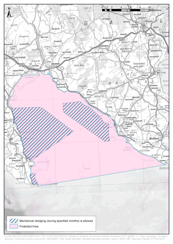
3.—(1) Subject to paragraphs (2) and (3), fishing for sea fish with a dredge, beam trawl, demersal seine net or demersal trawl is prohibited in the Luce Bay Protected Area.
(2) Subject to paragraph (3), the prohibition in paragraph (1) does not apply to fishing for sea fish with a mechanical dredge in the First Excepted Area, the Second Excepted Area or the Third Excepted Area—
(a)between 1st January and 28th February in each year (both dates inclusive); and
(b)between 1st November and 31st December in each year (both dates inclusive).
(3) In relation to each leap year, the reference in paragraph (2)(a) to 28th February is to be read as a reference to 29th February.
Revocation
4. In Schedule 1 to the Inshore Fishing (Prohibition of Fishing and Fishing Methods) (Scotland) Order 2004(), the entry relating to Luce Bay, listed as item 1 in column 1, is revoked.
RICHARD LOCHHEAD
A member of the Scottish Government
St Andrew’s House,
Edinburgh
16th December 2015
Articles 2 and 3
SCHEDULELUCE BAY PROTECTED AREA
PART 1DESCRIPTION OF THE LUCE BAY PROTECTED AREA
Interpretation
1. In Part 1 of this Schedule—
Description of the Luce Bay Protected Area
2. The Luce Bay Protected Area is that part of Scottish inshore waters, including the seabed and subsoil, which is enclosed by the boundary lines (the topographical descriptions of which are provided in the third column of the following table) which join in the order given the co-ordinates listed in the second column.
| Boundary Line | Co-ordinates between which the boundary line extends | Topographical description of boundary line |
|---|
| 1. | A to B | Geodesic line |
| 2. | B to A | Line following the mean high water spring mark |
PART 2DESCRIPTION OF THE FIRST EXCEPTED AREA
Interpretation
3. In Part 2 of this Schedule—
co-ordinate “C” is 54°47.652′ North latitude and 004°56.936′ West longitude;
co-ordinate “D” is 54°47.772′ North latitude and 004°50.623′ West longitude;
co-ordinate “E” is 54°44.766′ North latitude and 004°43.778′ West longitude; and
co-ordinate “F” is 54°41.142′ North latitude and 004°52.911′ West longitude.
Description of the First Excepted Area
4. The First Excepted Area is that part of Scottish inshore waters within the Luce Bay Protected Area, including the seabed and subsoil, which is enclosed by the boundary lines (the topographical descriptions of which are provided in the third column of the following table) which join in the order given the co-ordinates listed in the second column.
| Boundary Line | Co-ordinates between which the boundary line extends | Topographical description of boundary line |
|---|
| 1. | C to D | Geodesic line |
| 2. | D to E | Geodesic line |
| 3. | E to F | Geodesic line |
| 4. | F to C | Line following the mean high water spring mark |
PART 3DESCRIPTION OF THE SECOND EXCEPTED AREA
Interpretation
5. In Part 3 of this Schedule—
co-ordinate “G” is 54°39.510′ North latitude and 004°52.982′ West longitude;
co-ordinate “H” is 54°39.672′ North latitude and 004°51.806′ West longitude;
co-ordinate “I” is 54°39.366′ North latitude and 004°52.009′ West longitude;
co-ordinate “J” is 54°39.048′ North latitude and 004°52.001′ West longitude; and
co-ordinate “K” is 54°38.265′ North latitude and 004°51.258′ West longitude.
Description of the Second Excepted Area
6. The Second Excepted Area is that part of Scottish inshore waters within the Luce Bay Protected Area, including the seabed and subsoil, which is enclosed by the boundary lines (the topographical descriptions of which are provided in the third column of the following table) which join in the order given the co-ordinates listed in the second column.
| Boundary Line | Co-ordinates between which the boundary line extends | Topographical description of boundary line |
|---|
| 1. | G to H | Geodesic line |
| 2. | H to I | Geodesic line |
| 3. | I to J | Geodesic line |
| 4. | J to K | Geodesic line |
| 5. | K to G | Line following the mean high water spring mark |
PART 4DESCRIPTION OF THE THIRD EXCEPTED AREA
Interpretation
7. In Part 4 of this Schedule—
co-ordinate “L” is 54°48.210′ North latitude and 004°45.988′ West longitude;
co-ordinate “M” is 54°48.462′ North latitude and 004°42.378′ West longitude;
co-ordinate “N” is 54°47.964′ North latitude and 004°41.269′ West longitude;
co-ordinate “O” is 54°47.724′ North latitude and 004°40.303′ West longitude;
co-ordinate “P” is 54°46.410′ North latitude and 004°37.858′ West longitude;
co-ordinate “Q” is 54°45.942′ North latitude and 004°37.404′ West longitude;
co-ordinate “R” is 54°45.678′ North latitude and 004°36.285′ West longitude;
co-ordinate “S” is 54°44.196′ North latitude and 004°36.328′ West longitude;
co-ordinate “T” is 54°43.824′ North latitude and 004°36.103′ West longitude;
co-ordinate “U” is 54°43.626′ North latitude and 004°36.065′ West longitude:
co-ordinate “V” is 54°43.506′ North latitude and 004°37.046′ West longitude; and
co-ordinate “W” is 54°47.178′ North latitude and 004°45.916′ West longitude.
Description of the Third Excepted Area
8. The Third Excepted Area is that part of Scottish inshore waters within the Luce Bay Protected Area, including the seabed and subsoil, which is enclosed by the boundary lines (the topographical descriptions of which are provided in the third column of the following table) which join in the order given the co-ordinates listed in the second column.
| Boundary Line | Co-ordinates between which the boundary line extends | Topographical description of boundary line |
|---|
| 1. | L to M | Geodesic line |
| 2. | M to N | Geodesic line |
| 3. | N to O | Geodesic line |
| 4. | O to P | Geodesic line |
| 5. | P to Q | Geodesic line |
| 6. | Q to R | Geodesic line |
| 7. | R to S | Geodesic line |
| 8. | S to T | Geodesic line |
| 9. | T to U | Geodesic line |
| 10. | U to V | Geodesic line |
| 11. | V to W | Geodesic line |
| 12. | W to L | Geodesic line |
EXPLANATORY NOTE
Article 11(1) of Regulation (EU) No 1380/2013 of the European Parliament and of the Council on the Common Fisheries Policy (OJ L 354, 28.12.2013, p.22) empowers EU member States to adopt conservation measures which are necessary for compliance with obligations under EU environmental legislation. This Order prohibits, subject to certain exceptions, specified methods of fishing within an area in Luce Bay which has been designated as a Special Area of Conservation.
Article 3 and the Schedule prohibit fishing for sea fish with specified fishing gear – a dredge, beam trawl, demersal seine net or demersal trawl – throughout the whole year in the protected area. However, this prohibition is subject to an exception, the effect of which is to allow fishing for sea fish using a mechanical dredge in three excepted areas within the larger protected area, during the months of January, February, November and December in each year.
Article 4 revokes an entry in Schedule 1 to the Inshore Fishing (Prohibition of Fishing and Fishing Methods) (Scotland) Order 2004 (“the 2004 Order”) which imposed a seasonal prohibition on fishing for sea fish with specified fishing gear. That seasonal prohibition is being replaced by the prohibition and exception specified in this Order. Separate restrictions also apply in the protected area in relation to fishing for sea fish with creels (under Schedule 2 to the 2004 Order) and in relation to fishing for scallops during specified times of the year (under the Scallops (Irish Sea) (Prohibition of Fishing) (Variation) Order 1986 – S.I. 1986/988).
Any person who contravenes a provision contained in this Order commits an offence under section 4 of the Inshore Fishing (Scotland) Act 1984.
An illustrative map showing the Luce Bay protected area and the three excepted areas is appended to this Note.
A business and regulatory impact assessment has been prepared in relation to this Order and placed in the Scottish Parliament Information Centre. A copy of this can be obtained from Marine Scotland, the Scottish Government, Victoria Quay, Edinburgh EH6 6QQ.