
Article 4
SCHEDULE 1HARBOUR LIMITS
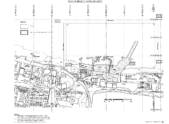
Harbour Limits
The area identified as “Limits” by the legend on the harbour map bounded as follows:
Commencing at point 1 and proceeding in a northerly direction to point 2; thence in an easterly direction to point 3; thence in a southerly direction to point 4; thence proceeding in a generally westerly direction along the line of mean low water springs to point 5; thence proceeding in a south westerly direction and then in a southerly direction to point 6; thence in a westerly, then north westerly, then again westerly, and then south westerly direction following the curve of the northern edge of the northern footpath adjacent to the roadway known as Market Road, Brodick to point 7; thence in a north westerly direction to point 8; thence in a northerly direction to point 9; thence in a north westerly direction to point 10; thence in a generally northerly, then south westerly, and then north westerly direction along the level of mean high water springs to point 1.
The points referred to above are as detailed in the table below.
| Point No. | Eastings | Northings |
|---|---|---|
| 1 | 202080E | 635920N |
| 2 | 202079E | 636180N |
| 3 | 202569E | 636180N |
| 4 | 202569E | 635928N |
| 5 | 202400E | 635931N |
| 6 | 202381E | 635853N |
| 7 | 202152E | 635866N |
| 8 | 202142E | 635871N |
| 9 | 202146E | 635883N |
| 10 | 202135E | 635883N |
Article 4
SCHEDULE 2HARBOUR MAP
Article 58
SCHEDULE 3ENACTMENTS REPEALED
| Chapter | Short Title | Extent of Repeal |
|---|---|---|
| 1920 c. lviii | Brodick Lamlash Lochranza and Whiting Bay Piers Order Confirmation Act 1920 | Whole Act in so far as applicable to the harbour |
| 1938 c. lxv | Island of Arran Piers Order Confirmation Act 1938 | Whole Act in so far as applicable to the harbour |
| 1951 c. vi | Island of Arran Piers Order Confirmation Act 1951 | Whole Act in so far as applicable to the harbour |