Print Options
PrintThe Whole
Instrument
PrintThis
Explanatory Note
only
Status:
This is the original version (as it was originally made). This item of legislation is currently only available in its original format.
Explanatory Note
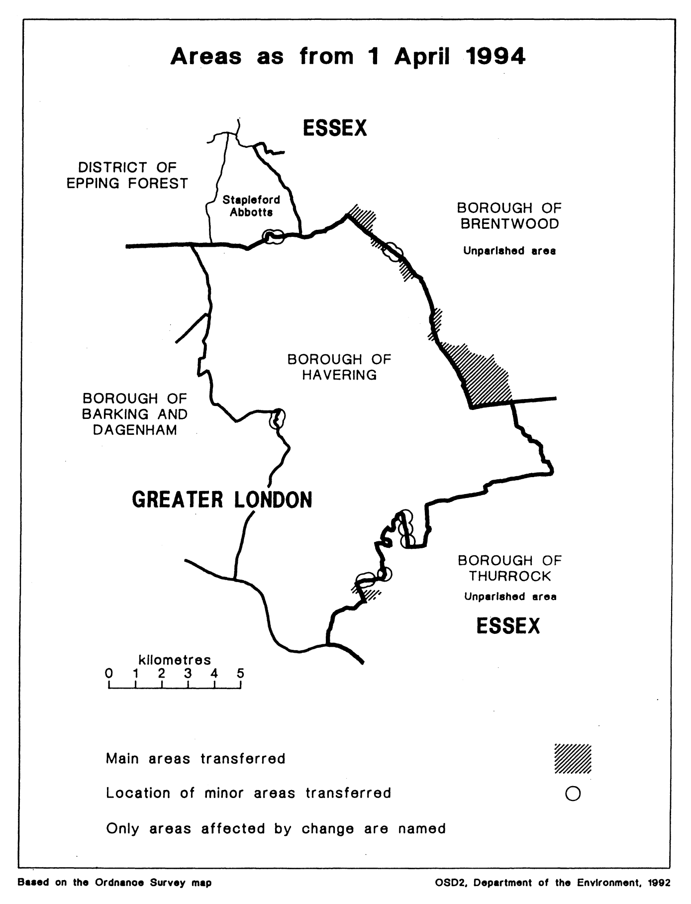
This Order makes mainly small changes to the boundary between Greater London and Essex, affecting the London borough of Havering, and the Essex districts of Brentwood, Epping Forest and Thurrock.
It also transfers areas within Greater London between Havering and the London borough of Barking and Dagenham.
Consequential changes to local government electoral areas, petty sessional divisions and coroner’s districts are made.
The map and table forming part of this note (Pages 4 to 6) give a general guide to the areas affected, and to their size and population.
Prints of the detailed maps (described in article 2) may be inspected at all reasonable times at the offices of the council for each borough or district affected, and additionally at the offices of the Secretary of State for the Environment located in 2, Marsham Street, London SW1P 3EB.
The Local Government Area Changes Regulations 1976 contain general provisions regarding the effect of orders such as this one.
TABLE SUMMARISING CHANGES MADE
| Article 3— Areas transferred between Essex and Greater London | Changes made—
1. Transfer to Brentwood of part of Havering Plain, including parts of Chequers Road and Weald Road.
|
| Brentwood to Havering Total area (in hectares)50 Population-2 Havering to Brentwood Total area-490 Population-140 | 2. Transfer to Brentwood of area located to the west of Great Warley, to the north-west of Stonyhills Farm, and to the east of the M25 motorway.
3. Transfer to Brentwood of large area located to the east of the M25 motorway near its junction with the A127 road, including Codham Hall, Great Warley Hall, and Hale Farm.
|
| Article 4Areas transferred between Essex and Greater London | At Stapleford Abbotts, realignments to more defined boundary in area located to the south of Oak Hill Road, and to north and north-west of Hillside Farm. |
| Epping Forest to Havering Total area-2 Population-Nil Transfers from Havering to Epping Forest Total area-1 Population-3 |
| ArticleAreas transferred between Essex and Greater London | Transfer to Thurrock of area to the east of the A13 road in the vicinity of Sandy Lane, including Sandy Lane Farm. |
| Transfers from Thurrock to Havering Total area-6 Population-3 | Realignment in the vicinity of the A13 road at Moor Hall, the Willows, Wennington Hall Farm and New Farm. |
| Transfers from Havering to Thurrock Total area-30 Population-3 | Realignment to eastern edge of Aveley Road between Warwick Lane and the brook on the southern edge of Running Water Wood. |
| Article 6-Areas transferred within Greater London between Barking and Havering | Realignment of boundary to the centre of the River Rom in area south of Rush Green Road. |
| Transfers from Barking to Havering Total area-1 Population-Nil |
| Transfer from Havering to Barking Total area-1 Population-Nil |
The Essex and Greater London (County and London Borough Boundaries) Order 1993 (S. I. 1993 No. 1141) which also comes fully into force on 1st April 1994, makes small adjustments to the boundary between—
(i)Essex (Epping Forest) and Greater London (London borough of Enfield); and
(ii)within Greater London, between the London borough of Waltham Forest and its neighbouring London boroughs of Enfield, Hackney and Haringey.
Back to top