1993 No. 2971
The Hereford and Worcester and West Midlands (County Boundaries) Order 1993
Made
Laid before Parliament
Coming into force
for the purposes referred to in article 1(2)
for all other purposes
The Secretary of State, in exercise of his powers under sections 51(2) and 67(4) and (5) of the Local Government Act 19721 and of all other powers enabling him in that behalf, hereby makes the following Order which gives effect to proposals submitted to him under sections 47, 48(1) and 51(1) of that Act, more than six weeks before the making of this Order, by the Local Government Boundary Commission for England:
Citation and commencement1
1
This Order may be cited as the Hereford and Worcester and West Midlands (County Boundaries) Order 1993.
2
This Order shall come into force on 1st December 1994 for any purpose set out in regulation 4(1) of the Local Government Area Changes Regulations 19762.
3
For all other purposes, this Order shall come into force on 1st April 1995.
Interpretation2
In this Order—
“district” includes a city;
“electoral division” means an electoral division of the county of Hereford and Worcester or of the county of West Midlands;
“Hereford and Worcester” means the county of Hereford and Worcester, and “Bromsgrove” means the district of Bromsgrove in that county;
“the map” means one of the 3 maps prepared by the Department of the Environment, marked “Maps of the Hereford and Worcester and West Midlands (County Boundaries) Order 1993”, and deposited in accordance with regulation 5 of the Local Government Area Changes Regulations 1976;
“West Midlands” means the metropolitan county of West Midlands, and “Birmingham” means the city of Birmingham in that county; any reference to an area as “unparished” is a reference to that area not forming part of any parish; and
“ward” means a ward of the district from or to which an area is transferred.
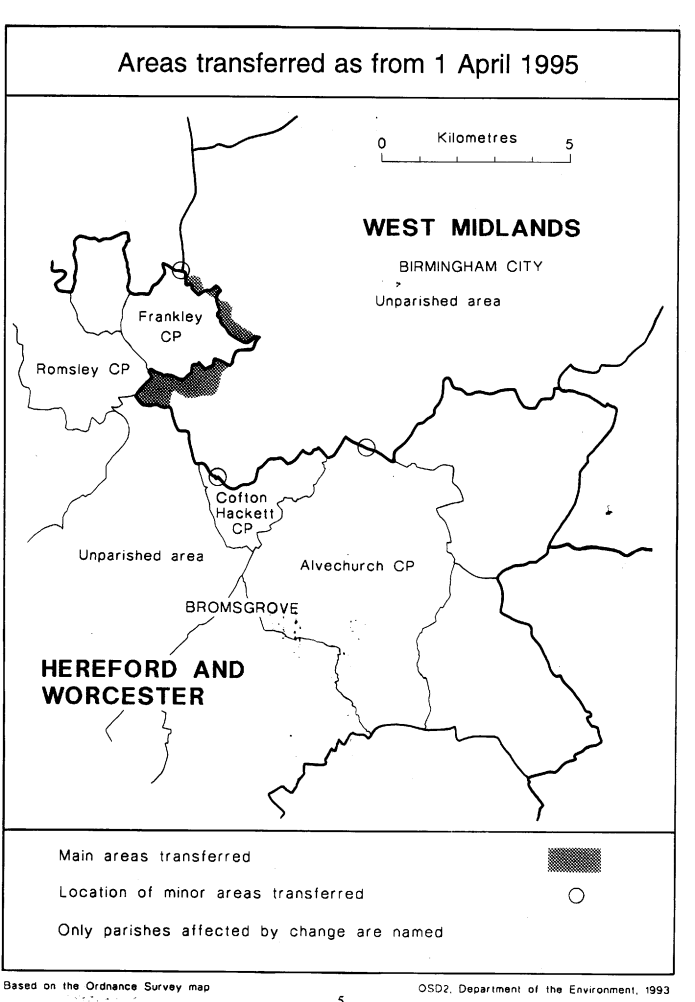
Transfers from Hereford and Worcester (Bromsgrove) to West Midlands (Birmingham)3
Each area which is marked as shown in column 1 of the following Table on the map indicated in column 2 shall be transferred from Hereford and Worcester, from Bromsgrove, and from the ward named in column 3 to—
a
West Midlands;
b
Birmingham;
c
the ward mentioned in column 4;
d
the Birmingham petty sessional division and the Birmingham coroner’s district and shall remain unparished.
(1) | (2) | (3) | (4) |
|---|---|---|---|
Area marked— | On map— | Transferred from Hereford and Worcester, from Bromsgrove, and from following ward— | To West Midlands, to Birmingham, and to the the following ward— |
B1 & B2 | 1 | Uffdown | Bartley Green |
B3, B4 & B5 | 1 | Uffdown | Longbridge |
B6 | 1 | Waseley | Longbridge |
B7 | 3 | Cofton Hackett | Longbridge |
2
The areas marked B1, B2, B3 and B4 on map 1 shall additionally transfer from the parish of Frankley, the area marked B5 on map 1 shall additionally transfer from the parish of Romsley and the area marked B7 on map 3 shall additionally transfer from the parish of Cofton Hackett.They shall become unparished.
Transfers from West Midlands (Birmingham) to Hereford and Worcester (Bromsgrove)4
Each area which is marked as shown in column 1 of the following Table on the map indicated in column 2 shall be transferred from West Midlands, from Birmingham, and from the ward named in column 3 to—
a
Hereford and Worcester;
b
Bromsgrove;
c
the parish, ward and electoral division mentioned in column 4;
d
the Bromsgrove and Redditch petty sessional division and the North Eastern Hereford and Worcester coroner’s district.
(1) | (2) | (3) | (4) |
|---|---|---|---|
Area marked— | On map— | Transferred from West Midlands, from Birmingham and from the following ward— | To Hereford and Worcester, to Bromsgrove, and to the following parish, ward, and electoral division— |
C1 & C3 | 1 | Bartley Green | Frankley Uffdown Ward Uffdown Electoral Division |
C2 | 2 | Kings Norton | Alvechurch Hopwood Ward Alvechurch Electoral Division |
Transfer within Hereford and Worcester (Bromsgrove)5
The area marked A1 on map 1 shall be transferred from the parish of Romsley to the parish of Frankley.
Town and country planning6
1
In this article, “provision” means a provision of a development plan (as defined in section 336 of the Town and Country Planning Act 19903).
2
Any provision applying to an area transferred by this Order shall continue to apply to that area, notwithstanding the transfer, until replaced by a provision which so applies, and which is expressed to supersede the preserved provision.
Signed by authority of the Secretary of State for the Environment
(This note is not part of the Order)
This Order makes changes in the boundary between the county of Hereford and Worcester and the metropolitan county of West Midlands, affecting the district of Bromsgrove in Hereford and Worcester and the city of Birmingham in West Midlands.
Consequential changes to local government electoral areas, petty sessional divisions and coroners' districts are made. No parishes are affected.
The map and table forming part of this Note are a general guide only to the areas affected. The table gives in approximate terms the hectarage and population affected by the transfers. The maps described in article 2 should be inspected for full details of the transfers. Any person may inspect the maps at any reasonable time at the offices of the Birmingham City Council and of the Bromsgrove District Council, and additionally at the offices of the Secretary of State for the Environment located in 2, Marsham Street, London SW1P 3EB.
The Local Government Area Changes Regulations 1976 contain general provisions regarding the effect of orders such as this one.
Area: 200 Hectares | Population: 8800 |
General description of transfers Transfer of area east of Ravenhayes Lane to unite Kitwell Estate in Birmingham.
Transfer of area lying between Scotland Lane and Frankley Lodge Lane, including parts of Bartley and Frankley Reservoirs, but excluding St. Leonard’s Church, Frankley.
Transfer of area at Frankley, located north of New Inns Lane, east of Gannow Green, and south of Egghill and Lower Hill Farms.
Transfer of old people’s housing in Cofton Hackett, east of Lickey Road.
Area: 5 Hectares | Population: Nil |
General description of transfers Realignments in the vicinity of Kitwell and Bromwich Wood.
Realignments to south side of Redhill Road, north of University Farm.
Area: 1 Hectare | Population: Nil |