
Print Options
PrintThe Whole
Instrument
PrintThis
Explanatory Note
only
Status:
This is the original version (as it was originally made). This item of legislation is currently only available in its original format.
Explanatory Note
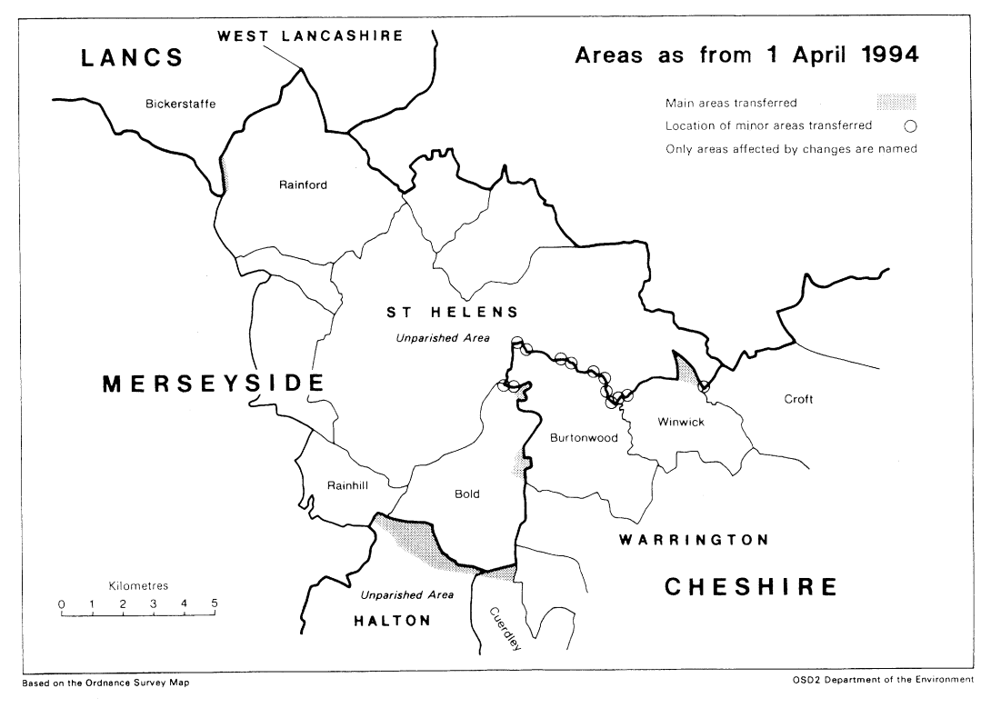
This Order makes alterations to county boundaries in the vicinity of the metropolitan borough of St. Helens in Merseyside. Areas are transferred from Cheshire (Warrington) to St. Helens, and from St. Helens to Cheshire (Halton and Warrington). One small change is also made in the boundary between St. Helens and Lancashire (West Lancashire).
The map and table forming part of this note (Pages 4, 5 and 6) give a general guide to the areas affected, and their approximate size and population. Prints of the detailed maps (described in article 2) may be inspected at all reasonable times at the offices of the council for each borough or district affected, and additionally at the offices of the Secretary of State for the Environment located in 2, Marsham Street, London SW1P 3EB.
The Local Government Area Changes Regulations 1976 contain general provisions regarding the effect of orders such as this one.
TABLE SHOWING CHANGES EFFECTED
Transfers from Cheshire (Warrington) to Merseyside (St. Helens)—
Article 2
Total area: 30 hectares
Population: Nil
Main transfer of—
Open land located north-west of Burtonwood Airfield and south-east of Moat House Farm, including part of M62 motorway.
Transfers from Merseyside (St. Helens) to Cheshire (Halton)—
Article 4
Total area: 260 hectares
Population: 120
Transfer of—
1. Large area stretching from Wilmore Lane eastwards to the junction of Mill Green Lane and Farnworth Road, including Wilmore House, Bank Head, Cranshaw Hall, Mill Green Farm and part of Lunt’s Bridge Farm.
2. Area located to the south of Old South Lane and Farnsworth Road and to the north of Barrows Green, including Knight’s House Farm, Boundary Farm and part of the railway line near Widnes East Junction.
3. Area running eastwards from the A540 road (in the vicinity of Norland’s Lane), and including Sandhill Farm, Harefield Farm and Rainhill Place Farm.
Transfers from Merseyside (St. Helens) to Cheshire (Warrington)—
Article 5
Total area: 60 hectares
Population: 10
Main transfer of— Area located to the east of Parkside Colliery, to the north of Hermitage Lane, and to the west of the M6 motorway.
Transfer from Lancashire (West Lancashire) to Merseyside (St. Helens)—
Article 6
Total area: 10 hectares
Population: Nil
Transfer of—
Largely open area located south of Moss Farm and in the vicinity of Canholes Wood, so that boundary follows the western side of Coach Road.
Location of minor realignments (articles 3 and 5)
1. In area north-east of Bold colliery and north-west of Burtonwood Brewery.
2. In following neighbourhoods, to follow centre of Sankey Brook-Red Brow Wood/Vulcan Village/Sankey Valley Park/Mill Farm/Sankey Viaduct.
3. At the Waterworks Lane bridge over the M6 motorway.
|
Back to top


