SCHEDULE 1RESTRICTED AREAS
Specially Protected Area No. 1 Taylor Rookery, MacRobertson Land Lat. 67°26'S; Long. 60°50'E
the Area consists of the whole of the northernmost rock exposure on the east side of Taylor Glacier, MacRobertson Land (Lat. 67°26'S; Long. 60°50'E). The rookery is located on a low lying rock outcrop in the south-west corner of a bay formed by Taylor Glacier to the west, the polar ice cap to the south and the islands of Colbeck Archipelago to the east. The Area is surrounded by sea ice to the north and east. The Area is some 90 km west of Mawson station. There is ice-free terrain adjacent to the glacier on the western boundary and to the south the rock rises steeply to meet the ice of the plateau.
There are no boundary markers since the Area is easily defined by its natural features.

Specially Protected Area No. 2 Rookery Islands, Holme Bay, MacRobertson Land Lat. 67°37'S; Long. 62°33'E
The Rookery Islands are a group of small islands and rocks in the south-western part of Holme Bay, MacRobertson Land, approximately 10 km to the west of Mawson station. The Area comprises the islands and rocks lying within the rectangular area shown on the maps below, the general location of which is latitude 67°37'S, longitude 62°33'E. There are no boundary markers delimiting the site.
There are approximately 75 small islands. They range in size from small rocks which barely remain above water at high tide to the largest islands of the group which are Giganteus Island (approximately 400 m long, 400 m wide and 30 m high) and Rookery Island which is of similar size but slightly more elongated. Rookery Island is the highest of the group reaching an altitude of 62 m.

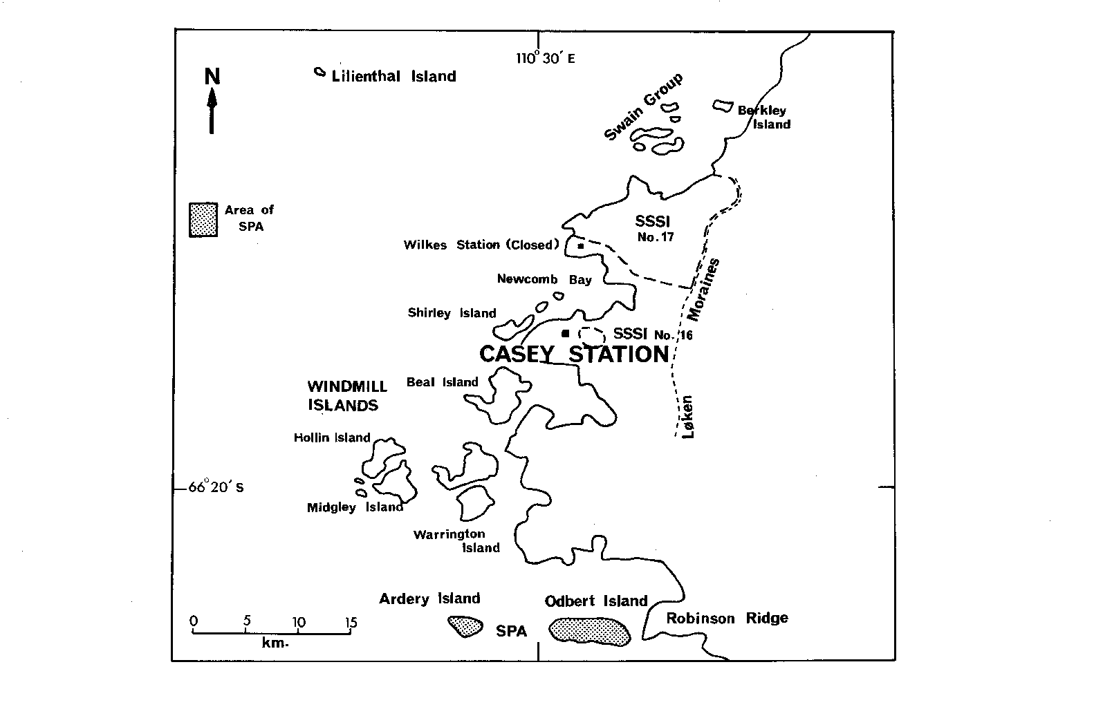
Specially Protected Area No. 3 Ardery Island and Odbert Island, Budd Coast Lat. 66°22'S; Long. 110°33'E
Ardery Island (Lat. 66°22'S, Long. 110°28'E) and Odbert Island (Lat. 66°22'S, Long. 110°33'E) form part of the Windmill Islands group lying in the eastern end of Vincennes Bay off the Budd Coast. They are located 5 km and 0.6 km respectively to the west of Robinson Ridge, south of Casey Station. Odbert Island is approximately 2.5 km long and 0.5 km wide. In some years the island remains joined to Robinson Ridge on the mainland by sea ice. Ardery Island is a steep ice-free island approximately 1 km long and 0.5 km wide, with an east-west orientation.
Specially Protected Area No. 20 “New College Valley”, Caughley Beach, Cape Bird, Ross Island Lat. 77°14'S; Long. 166°23'E
The Area is in latitude 77°14'S, longitude 166°23'E, in the northern part of the Cape Bird ice-free area. It lies between Northern Rookery and Middle Rookery and is about 250 m south of the summer research station, Cape Bird Hut.
The Area consists of the generally west-facing ice-free slopes lying between the cliff top above Caughley Beach and a line parallel to and about 100 m west of the edge of the Mount Bird Ice Cap, and between a line south of the main stream bed of “Keble Valley” and the south ridge of “New College Valley”. Its total area is about 10 hectares.
