
PART 2Advisory signs
Sign table — Schedule 11, Part 2
(1) Item | (2) Description | (3) Diagram | (4) Variants by reference to Part 5 | (5) Applicable provisions in Part 6 | (6) Schedule 11 General Directions |
|---|---|---|---|---|---|
| 1 | Diagram 811A and 811B Beginning and end of section of road where traffic has priority over vehicles from the opposite direction | 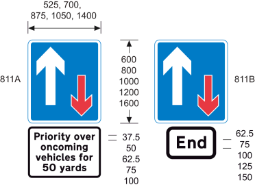 | 1, 2 | ||
| 2 | Diagram 810 One-way traffic (Sign for pedestrians) (Alternative types) | 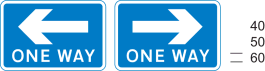 | 5 | ||
| 3 | Diagrams 814.2 and 814.4 Ramped access to or from a pedestrian subway or overbridge | 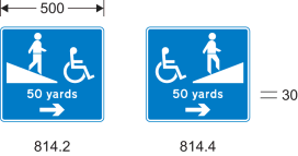 | 1, 2, 4, 5, 54 | 5 | |
| 4 | Diagrams 814.1 and 814.3 Stepped access to and from a pedestrian subway or overbridge | 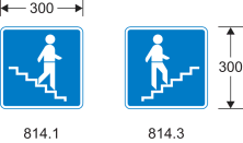 | 4 | 5 | |
| 5 | Diagram 816 No through road for vehicular traffic (Alternative types) |  | |||
| 6 | Diagram 816.1 Alternative to the sign shown at item 5 with a street nameplate | 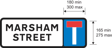 | 7 | 5 | |
| 7 | Diagram 817 No through road for vehicular traffic in direction indicated from junction ahead (Alternative types) | 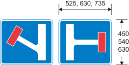 | 6 | ||
| 8 | Diagram 821 Road ahead only wide enough for one line of vehicles, and providing information about passing places (Alternative types) | 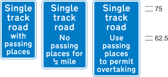 | 1 | ||
| 9 | Diagram 822 Passing place on narrow road | 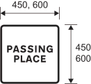 | |||
| 10 | Diagrams 892 and 893 Name and length of a tunnel on a motorway (892) or all‑purpose road (893) | 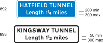 | 8 | ||
| 11 | Diagram 818.1 Section of dual carriageway road ahead | 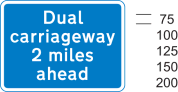 | 1, 2 | ||
| 12 | Diagram 818.1A Distance over which a short length of dual carriageway road beginning directly ahead extends (Alternative types) | 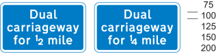 | |||
| 13 | Diagram 820.1 Absence of hard shoulder for the distance shown (Alternative types) | 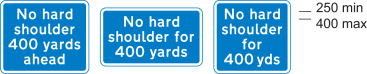 | 1 | ||
| 14 | Diagrams 873 and 874 Additional traffic joining from the left or right ahead (diagram shows blue background – for use on motorways) | 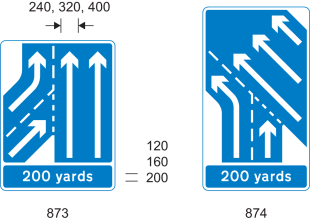 | 1, 2, 6, 26, 27 | ||
| 15 | Diagram 872.1 The number of traffic lanes reduces ahead (diagram shows blue background – for use on motorways) (Alternative types) | 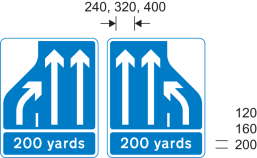 | 1, 2, 6, 26, 27 | ||
| 16 | Diagram 887 Overtaking lane ahead | 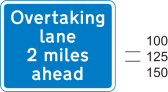 | 1, 2 | ||
| 17 | Diagram 888 Indication of length of road over which an overtaking lane is available on a single carriageway road, with a single traffic lane in the opposite direction (diagram shows green background – for use on primary routes) |  | 1, 27 | ||
| 18 | Diagram 889 Indication that only one lane of traffic, with no overtaking, is available on a single carriageway road with two traffic lanes in the opposite direction (diagram shows green background – for use on primary routes) | 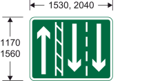 | 27 | ||
| 19 | Diagram 890 Distance ahead to a point where an overtaking lane ends on a single carriageway road (diagram shows green background – for use on primary routes) | 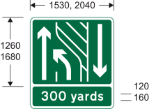 | 1, 2, 27 | ||
| 20 | Diagram 891 Distance ahead to a point where an overtaking lane ends on a single carriageway road on the approach to a dual carriageway road with only one traffic lane in each direction (diagram shows green background – for use on primary routes) | 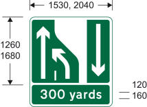 | 1, 2, 27 | ||
| 21 | Diagrams 823, 824 and 825 Distance in hundreds of yards to a roundabout or the next point at which traffic may leave a route (diagram shows blue background – for use on motorways) | 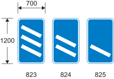 | 4, 26, 27 | ||
| 22 | Diagram 877 Appropriate traffic lanes for different manoeuvres at a junction ahead (diagram shows white background – for use on non-primary routes) (Alternative types) | 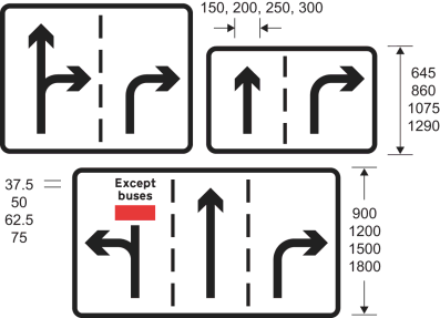 | 9, 26, 28 | ||
| 23 | Diagram 820 Route unsuitable for type of vehicle indicated (Alternative types) | 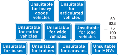 | 5(1) | ||
| 24 | Diagram 820A Road unsuitable for heavy goods vehicles (Alternative types) | 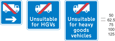 | 4, 5(1) | ||
| 25 | Diagram 829.5 Area where police carry out checks on the speed of vehicles | 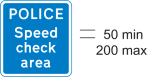 | |||
| 26 | Diagram 829.6 Waiting place for police or authorised vehicles only (Alternative types) | 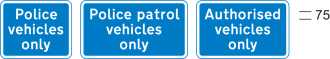 | |||
| 27 | Diagram 881 Start of a home zone designated under section 268 of the Transport Act 2000(1), or section 74(1) of the Transport (Scotland) Act 2001(2) |  | 24 | ||
| 28 | Diagram 882 End of a home zone indicated by the sign at item 27 | 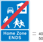 | |||
| 29 | Diagram 886 Road ahead where motorists, cyclists and pedestrians should expect to share the same space | 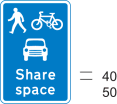 | |||
| 30 | Diagram 884 Start of a quiet lane in England designated under section 268 of the Transport Act 2000 | 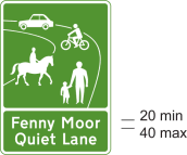 | 24 | ||
| 31 | Diagram 885 End of designated quiet lane in England | 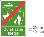 | |||
| 32 | Diagram 883 Indication of the start of area with traffic calming features (within the meaning of paragraph 1(3) of the Schedule 10 General Directions) | 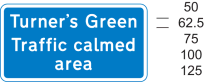 | 1, 5(1), 24 | ||
| 33 | Diagram 953.3 Entrance to a bus station, depot or garage |  | 5 | ||
| 34 | Diagram 962 Bus lane or lanes on a road at junction ahead, with indication of times of operation (Alternative types) |  | 10 | ||
| 35 | Diagram 962.1 Cycle lane on a road at junction ahead or cycle track crossing road, with indication of times of operation | 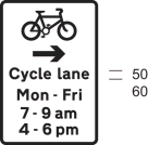 | 4, 10, 12 | ||
| 36 | Diagram 962.2 Contraflow bus lane ahead on a road at a junction which pedal cycles may also use (Alternative types) | 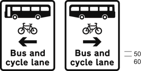 | |||
| 37 | Diagram 958 With-flow bus lane ahead which authorised vehicles, solo motor cycles, pedal cycles and taxis may also use, with indication of times of operation | 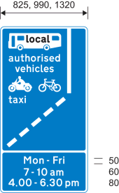 | 10, 11, 13, 14 | ||
| 38 | Diagram 958.1 With-flow mandatory cycle lane ahead, with indication of times of operation | 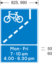 | 10, 14 | ||
| 39 | Diagram 2602.2 Numbered route for pedal cycles forming part of a regional (blue number patch) or national (red number patch) cycle route network (Alternative types) | 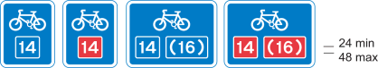 | 25 | 5 | |
| 40 | Diagram 963 Direction in which pedestrians should look for approaching traffic when crossing a bus lane (Alternative types) | 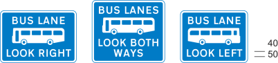 | 5 | ||
| 41 | Diagram 963.1 Direction in which pedestrians should look for approaching pedal cycles when crossing a cycle lane (Alternative types) | 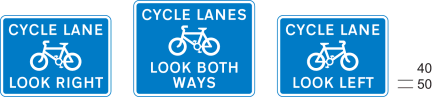 | 15 | 5 | |
| 42 | Diagram 963.2 Direction in which pedestrians should look for approaching traffic when crossing a contraflow bus lane which pedal cycles may also use (Alternative types) | 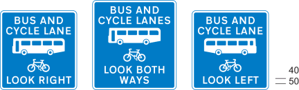 | 5 | ||
| 43 | Diagram 963.3 Direction in which pedestrians should look for approaching tramcars when crossing a tramway (Alternative types) | 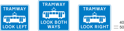 | 5 | ||
| 44 | Diagram 967 Route recommended for pedal cycles on the main carriageway of a road | 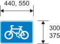 | 5 | ||
| 45 | Diagram 965 End of cycle lane, track or route | 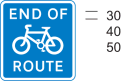 | 5 | ||
| 46 | Diagram 966 Pedal cyclists to rejoin main carriageway or dismount at the end of, or at a break in, a cycle track or route (Alternative types) |  | 5 | ||
| 47 | Diagram 968 and 968.1 Parking place for pedal cycles | 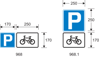 | 5 | ||
| 48 | Diagram 857.1 Information relating to a taxi rank for the number of taxis specified | 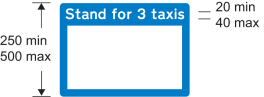 | 16 | 5 | |
| 49 | Diagram 2934 Drivers should keep or check their distance from the vehicle in front (Alternative types) | 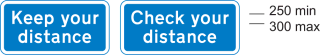 | |||
| 50 | Diagram 2933 Drivers should keep a distance of two chevron markings (the markings provided for at item 34 of the table in Part 4) from the vehicle in front |  | |||
| 51 | Diagrams 2032 and 2130 Primary route (2032) or non‑primary route (2130) forming part of a ring road | 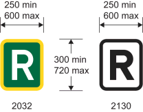 | |||
| 52 | Diagram 972 Stopping place for buses used for carrying tourists to allow passengers to take photographs | 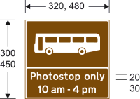 | 17, 34 | 5 | 2 |
| 53 | Diagram 857A Information for pedestrians about tourist destinations and leisure facilities in a nearby place or area | 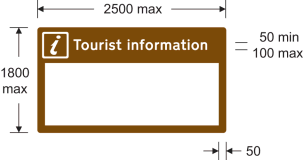 | 18, 19 | 5 | |
| 54 | Diagram 857B Information for pedestrians about tourist destinations and leisure facilities in a nearby place or area |  | 18 | 5 | |
| 55 | Diagram 2501 Distance to a parking place ahead |  | 1, 5(1) | ||
| 56 | Diagram 801 Parking place | 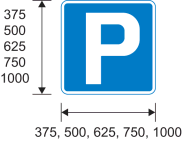 | |||
| 57 | Diagram 2713.1 Distance ahead to emergency telephone in a parking place or emergency lay‑by (Alternative types) | 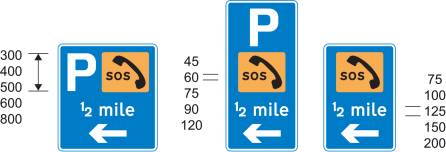 | 1, 2, 5 | ||
| 58 | Diagram 2713 Direction to nearest emergency telephone on same side of the road(diagram shows blue background – for use on motorways) (Alternative types) | 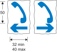 | 53 | 5 | |
| 59 | Diagram 2714 Side of emergency telephone box (Alternative types) |  | 29, 55 | 2, 6 | |
| 60 | Diagram 2715 Back of emergency telephone box (Alternative types) |  | 29, 55 | 2, 6 | |
| 61 | Diagram 2718 Route number and location reference |  | 29 | ||
| 62 | Diagram 2712 Location of fire rendezvous point (Alternative types) |  | 20 | 5 | |
| 63 | Diagram 878 Area in which enforcement cameras are in use (Alternative types) | 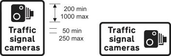 | 21 | ||
| 64 | Diagram 880 Speed camera ahead on a lit road and reminder of 30 mph speed limit | 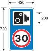 | 21(2) | ||
| 65 | Diagram 880.1 Speed camera ahead on an unlit road and reminder that a national speed limit applies | 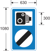 | 21(2) | ||
| 66 | Diagrams 827.1, 827.2 and 827.3 Hospital ahead | 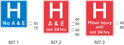 | 22 | ||
| 67 | Diagram 775 Vehicular traffic must not stop within the area of a railway or tramway level crossing |  | |||
| 68 | Diagram 783 Drivers of long low, large or slow vehicles must telephone to obtain permission before using a railway or tramway level crossing (Alternative types) | 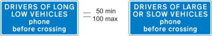 | |||
| 69 | Diagram 785.1 Name of level crossing and details of telephone number for contacting railway or tramway operator | 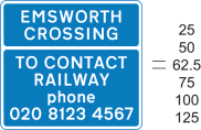 | 23 | ||
| 70 | Diagram 786 Place where large, slow or long low vehicles should wait near a railway or tramway level crossing while the driver obtains permission by telephone to cross or confirms he or she has crossed (Alternative types) | 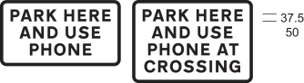 | 56 | ||
| 71 | Diagram 787 Site of telephone or emergency telephone at or near a railway or tramway level crossing (Alternative types) | 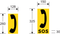 | |||
| 72 | Diagram 788 Direction to telephone or emergency telephone at or near a railway or tramway level crossing (Alternative types) | 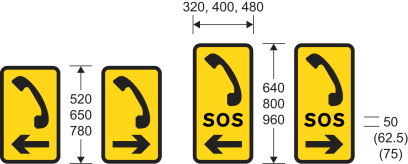 | |||
| 73 | Diagram 611 Vehicular traffic may reach the same destination by proceeding either side of the sign |  | 1, 4 | 1 | |
| 74 | Diagrams 833, 834, 835 and 836 Signs regulating the movement of vehicular traffic into and out of premises with more than one access to a road | 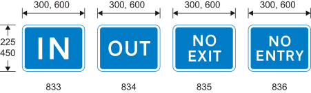 | 5 | ||
| 75 | Traffic mirror for providing additional visibility (not for use with traffic signals) | The mirror must be convex and any frame must be of a single colour, being black, grey, yellow or white | 13 | ||
| 76 | Diagram 970 Stopping place for buses | 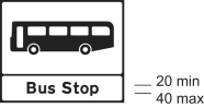 | 30, 31, 34 | 5 | 2 |
| 77 | Diagrams 973.2 and 973.3 Stopping place for buses operated by or on behalf of, or under agreement with, Transport for London | 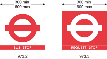 | 30, 32, 34 | 5 | 2 |
| 78 | Diagram 971 Stopping place for tramcars | 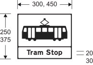 | 30, 33, 34 | 5 | 2 |
| 79 | Diagram 2928 Motorway sign indicating the boundary of an administrative area, a ceremonial area or an historic county area (Alternative types) | 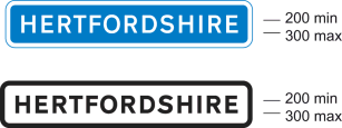 | 35 | ||
| 80 | Diagram 2401 Primary or non‑primary route sign indicating the boundary of an administrative area, a ceremonial area or an historic county area |  | 30, 36 | 5 | |
| 81 | Diagram 2402.1 Primary or non‑primary route sign indicating the name of a city, town or village commencing immediately ahead (Alternative types) | 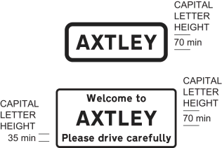 | 37 | 5 | 3 |
| 82 | Diagram 2403.1 Primary or non-primary route sign indicating the name of a city, town or village immediately ahead, together with extra local information | 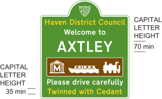 | 30, 38 | 5 | 4 |
| 83 | Diagram 2404 Primary or non-primary route sign indicating the name of a city, town, village, an administrative area, a ceremonial area or an historic county area immediately ahead, together with phrase and image that is representative of the city, town, village or area | 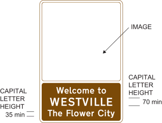 | 39 | 5 | 4 |
| 84 | Diagram 976 Maximum speed limit for tramcars in kilometres per hour |  | 40 | 5 | |
| 85 | Diagram 864.2 Vehicle testing station approved by the Driver and Vehicle Standards Agency | 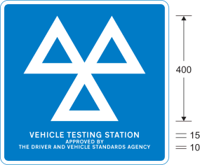 | 58 | 5 | |
| 86 | Diagram 865 Motor cycle test centre |  | 5 |