SCHEDULE 12Directional signs
PART 28Other directional signs
(1) Item | (2) Description | (3) Diagram | (4) Variants |
|---|---|---|---|
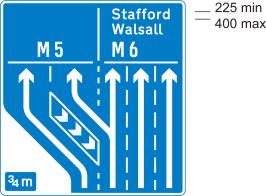
1 | Diagram 2904.2 Indication of road layout at a junction ¾ mile ahead on a motorway, where the left hand lane leaves the main carriageway and where the same exit can be accessed from the centre lane | 1. Destinations may be varied or added and may incorporate the legends shown in column 3 of the sign table in Part 3 at items 1 and 4, and the symbols shown in column 3 of the sign table in Part 11 at items 6, 7, 11, 12, 13 and 21; 2. The number of traffic lanes may be varied and the road marking symbols and arrows varied to represent the actual junction layout; where the two lanes shown for the junction exit lead to different destinations, the horizontal bar must be omitted and the broken line symbol representing the division of the lanes extended upwards; 3. The number of chevron symbols shown may be reduced from three to two, with the boundary line adjusted accordingly; 4. The distance to the junction may be omitted or varied in accordance with paragraph 7 of Part 3 of Schedule 18 | |
2 | Diagram 2017.1 Indication of road layout at a junction ¾ mile ahead on a primary route, where the left hand lane leaves the main carriageway and where the same exit can be accessed from the centre lane | 1. Destinations may be varied or added and may incorporate the legends shown in column 3 of the sign table in Part 3 at items 1 and 4, the panels shown in column 3 of the sign table in Part 9 at items 1 and 3, and the symbols shown in Part 11 (other than items 1 to 5); 2. The number of traffic lanes may be varied and the road marking symbols and arrows varied to represent the actual junction layout. Where the two lanes shown for the junction exit lead to different destinations, the horizontal bar must be omitted and the broken line symbol representing the division of the lanes extended upwards; 3. The number of chevron symbols shown may be reduced from three to two, with the boundary line adjusted accordingly; 4. The distance to the junction may omitted or varied in accordance with paragraph 7 of Part 3 of Schedule 18 | |
3 | Diagram 2019.1 Indication of appropriate traffic lanes at a junction or at a junction ahead where the right hand lane divides into two, the additional lane on the right leading to a different destination (diagram shows colours applicable to sign on a primary route) | 1. Destinations may be varied or added and may incorporate the legends shown in column 3 of the sign table in Part 3 at items 1, 2 and 4, the panels shown in Part 9 and the symbols shown in column 3 of the sign table in Parts 11 (other than items 1 to 5) and 20; 2. The number of traffic lanes and arrows, the widths of individual lanes and the lengths of horizontal bars, may be varied and may indicate an arrangement of shared lanes in a similar manner to column 3 of the sign table in Part 5 at item 5; 3. The route numbers must be white and the background blue when the sign is placed on a motorway exit slip road or the main carriageway of a motorway where it terminates at a junction ahead; 4. The legend, traffic lane symbols, arrows and sign border must be black and the background white when the sign is placed on a non-primary route | |
4 | Diagram 2912 Junction ahead on a motorway with another motorway | 1. Route numbers may be varied in accordance with the entries in column 3 of the sign table in Part 3 at item 4; 2. The junction number in white numerals on the blue background may be added after the word “Junction”; 3. Numerals indicating the distance in miles may be varied with the distance being expressed in miles to the nearest mile | |
5 | Diagrams 2010.1 and 2010.2 Prohibited movement ahead on a primary route with an indication of a route avoiding that prohibition | 1. Numerals in the upper panel of diagram 2010.1 indicating the distance to the prohibited turn may be varied; 2. The route symbols and representation of the road layout may be varied, except that the width of the route symbols must not be varied; 3. The “no right turn” symbol may be reversed to indicate a prohibited left turn or, in diagram 2010.1, varied to the “no U-turn” symbol shown in column 3 of the sign table in Part 20 at item 20; 4. Destinations may be varied or added and may incorporate the legends shown in column 3 of the sign table in Part 3 of this Schedule at items 1 and 4, the panels shown in Part 9 and the symbols shown in Part 11 (other than items 1 to 5); 5. The names of destinations and route numbers may be placed directly on the green background, with the white background omitted, provided destinations are in white lettering and the route numbers are in yellow. | |
6 | Diagrams 2123 and 2124 Prohibited movement ahead on a non-primary route with an indication of a route avoiding that prohibition | 1. Numerals in the upper panel of diagram 2123 indicating the distance to the prohibited turn may be varied; 2. The route symbols and representation of the road layout may be varied as appropriate, except that the width of the route symbols must not be varied; 3. The “no right turn” symbol may be reversed to indicate a prohibited left turn or, in diagram 2123, varied to the “no U-turn” symbol shown in column 3 of the sign table in Part 20 at item 20; 4. Destinations may be varied or added and may incorporate the legends shown in column 3 of the sign table in Part 3 at items 1 and 4, the panels shown in Part 9 and the symbols shown in Part 11 (other than items 1 to 5) | |
7 | Diagram 2141 Direction for traffic on a minor route to a destination reached along another minor route (Alternative types) | 1. Place names may be varied or added in accordance with column 3 of the sign table in Part 3 at item 1 in and may be shown in lower case letters with initial capitals; 2. A distance may be added; 3. The shape of the end of the sign may be varied; 4. A thin black border may be added or omitted as appropriate; 5. The sign may point to the left | |
8 | Diagram 2215 Junction ahead leading to a place or geographical area containing several tourist destinations or leisure facilities (Alternative types) | 1. The place name and the name of the tourist destination or leisure facility may be varied in accordance with column 3 of the sign table in Part 3 at items 1 and 3; 2. The number of tourist destinations or leisure facilities shown on the lower part of the sign may be varied, but must not exceed five and, in the case of a sign placed on a motorway, must not exceed three; 3. The symbols may be varied to those shown in Parts 14 to 18; 4. A distance in relation to each destination shown on the sign may be added; 5. The direction in which the arrow points may be varied | |
9 | Diagram 2205 Sign on a primary or non-primary route indicating location of a Tourist Information Centre or Point | 1. The name of a place or geographical area may be added in the same size of letters as “Tourist information centre”; 2. “centre” may be omitted; 3. The distance may be varied in accordance with Part 3 of Schedule 18; 4. The arrow may be reversed to point horizontally to the right; 5. The distance, the arrow or both may be omitted | |
10 | Diagram 2307 Sign on a primary or non-primary route indicating distance ahead to a parking place with public toilets that has facilities for disabled persons, Tourist Information Centre or Point, public telephone, picnic area and viewpoint | 1. The name of the place may be varied (including to a geographical area) or omitted; 2. The recycling symbol shown in column 3 of the sign table in Part 11 at item 14 may be added; 3. Any of the symbols may be omitted but there must be at least two symbols on the sign including the “P” and either the “i”, picnic area or viewpoint symbol. The wheelchair symbol, when used, must be placed to the right of the “WC” symbol; it must not be included without the “WC” symbol; 4. The distance may be varied in accordance with Part 3 of Schedule 18; 5. An arrow pointing horizontally to the left or to the right may be added; 6. The wheelchair and viewpoint symbols must be reversed when an arrow pointing to the right is added; 7. The distance may be omitted when an arrow is added | |
11 | Diagram 2301.1 Sign on a primary or non-primary route indicating distance and direction to a caravan site which has at least 20 pitches (where the site is both a caravan and a camping site, the reference to the number of pitches includes both pitches for caravans and for tents) | 1. The name of the caravan site may be varied or omitted; 2. The distance may be varied in accordance with Part 3 of Schedule 18; 3. The arrow may be reversed to point horizontally to the right; 4. The distance or the arrow, but not both, may be omitted | |
12 | Diagram 2301.2 Sign on a primary or non-primary route indicating distance and direction to a camping site which has at least 20 pitches (where the site is both a caravan and a camping site, the reference to the number of pitches includes both pitches for caravans and for tents) | 1. The name of the camping site may be varied or omitted; 2. The distance may be varied in accordance with Part 3 of Schedule 18; 3. The arrow may be reversed to point horizontally to the right; 4. The distance or the arrow, but not both, may be omitted | |
13 | Diagram 2303 Sign on a primary or non-primary route indicating distance and direction to a hostel | 1. “Youth Hostel” may be varied to “Tourist hostel” in which case the symbol must be omitted; 2. The distance may be varied in accordance with Part 3 of Schedule 18; 3. The arrow may be reversed to point horizontally to the right; 4. The distance or the arrow, but not both, may be omitted | |
14 | Diagram 2305 Sign on a primary or non-primary route indicating distance and direction to a picnic area | 1. The name of the picnic area may be varied or omitted; 2. The distance may be varied in accordance with Part 3 of Schedule 18; 3. The arrow may be reversed to point horizontally to the right; 4. The distance or the arrow, but not both, may be omitted | |
15 | Diagram 2703.1 Permanently mounted sign indicating a diversion route (Type A and B) | 1. The symbol may be varied to one shown in column 3 of the table in Part 11 at item 13; more than one symbol may be shown; 2. Where a symbol is placed above another, the size and proportions of the chevron in diagram B must be varied as appropriate; 3. The direction in which the arrow points in diagram A may be varied; when pointing to the left the arrow must be placed to the left of the symbol; 4. When the arrow in diagram A is pointing ahead it may be placed either to the left or to the right of the symbol and diagram B, shown in column 3 of the sign table in Part 5 at item 1, must be used where there is one symbol or a single row of symbols; 5. The arrow in diagram A may be varied to the arrow shown in column 3 of the sign table in Part 5 at item 2 ; 6. The sign shown by diagram B may be reversed to point left | |
16 | Diagrams 2709 and 2710 Permanently mounted sign indicating a route for emergency vehicles to a named emergency services incident point | 1. The name of the incident point may be varied or omitted; 2. The direction in which the arrow points in diagram 2709 may be varied; 3. The arrow in diagram 2709 may be omitted and the U-turn arrow, in white, shown in column 3 of the sign table in Part 5 at item 2, placed to the right of the legend; 4. The sign shown by diagram 2710 may be reversed to point right | |
17 | Diagram 2711.1 Direction and distance to emergency exit for pedestrians from a tunnel (Alternative types) | 1. The symbols and arrows may be reversed to indicate an exit to the left; 2. The arrow in diagram B may point vertically upwards with the symbol facing either to the left or to the right; 3. The distance may be varied or omitted; 4. Where emergency exits are more than 880 yards apart, distances must be expressed in miles, denoted by “miles” or “mile” as appropriate, and must be to the nearest ¼ mile with the fractions ¾, ½ and ¼ being used | |
18 | Diagram 2922 Exit from a motorway for works traffic only | ||
19 | Diagram 2801 and 2802 Sign on a primary or non-primary route indicating a route or direction to a testing station for goods vehicles | 1. The word “Goods” may be omitted or varied as appropriate to indicate the type or types of vehicle tested; 2. The testing station symbol may be omitted; 3. A distance may be added; 4. The direction in which the arrow points in diagram 2801 may be varied; when pointing to the right it must be placed on the right hand side of the sign with the symbol, if shown, placed to the left of the legend; 5. When the arrow in diagram 2801 is pointing ahead it may be placed either on the left hand or right hand side of the sign, with the symbol, if shown, placed at the opposite end of the sign; 6. The arrow in diagram 2801 may be omitted and the U-turn arrow shown in column 3 of the sign table in Part 5 at item 2, placed on the right hand side of the sign, with the symbol, if shown, placed to the left of the legend; 7. The sign shown by diagram 2802 may point to the left, with the symbol, if shown, placed to the right of the legend | |
20 | Diagram 2601.2 Indication of a route for cyclists through a road junction ahead (Alternative types) | 1. Destinations may be omitted, varied or added and may incorporate the legends shown in column 3 of the sign table in Part 3 at item 1; 2. A distance may be added; 3. The symbols indicating the road layout and the route for cyclists may be varied as appropriate except the individual symbol widths | |
21 | Diagram 2610.2 Direction along a public right of way, concessionary path or permissive path indicated by waymarks | 1. The direction in which the arrow points may be varied, the shaft may be extended and curved; 2. The colour of the arrow may be varied to indicate the type of route, with the background in any colour; 3. “Public Footpath”, “Footpath”, “Bridleway”, “Byway”, “Restricted Byway”, “Concessionary Path”, “Permissive Path” (or other appropriate description for conveying the direction of a public right of way, concessionary path or permissive path) may be added on, or adjacent to, the arrow; 4. The name of a destination, a route and an identifying symbol of a route, in any combination, may be added on or adjacent to the arrow; 5. A distance may be added; 6. A legend may be in any style, size and contrasting colour | |
22 | Diagram 818.4 Nature and location of a prohibition, restriction or requirement with indication of alternative route | 1. The legend above the “weight limit” symbol, indicating the nature and location of the prohibition, restriction or requirement, may be varied as appropriate; 2. The “weight limit” numeral may be varied; 3. The “weight limit” symbol may be varied to a symbol shown in column 3 of the sign table in Part 20 at items 25, 27, 33, 34 or 35 or omitted; 4. A distance to the location of the prohibition, restriction or requirement may be shown in accordance with Part 3 of Schedule 18; 5. An arrow pointing horizontally to the left or to the right may be added (and where an arrow pointing to the right is added, the lorry symbol is reversed); 6. “ahead” may be added after any distance where an arrow has not been added; 7. The legend below the “weight limit” symbol, indicating an alternative route, may be omitted or varied in accordance with column 3 of the sign table in Part 3 at item 8 and may include the words “Alternative route via” | |
23 | Diagram 818.5 Location of a low bridge with indication of alternative route | 1. The legend “south of Maplebeck” may be varied as appropriate or omitted 2. The numerals giving a height may be varied 3. A distance to the low bridge may be shown in accordance with Part 3 of Schedule 18 4. An arrow pointing horizontally to the left or to the right may be added 5. “ahead” may be added after any distance where an arrow has not been added 6. The legend below the “height limit” symbol, indicating an alternative route, may be omitted or varied and may include the legends shown in column 3 of the sign table in Part 3 at item 8 | |
24 | Diagram 2502 Sign on a primary or non-primary route indicating distance to a goods vehicles parking place ahead with public toilets and telephones | 1. The lorry, “WC” and telephone symbol may be omitted as appropriate 2. The recycling symbol shown in column 3 of the table in Part 11 at item 14 may be added 3. The “i” symbol shown in column 3 of the sign table in Part 11 at item 33 may be added where the parking place includes a general information point not associated with tourist destinations 4. The distance may be varied in accordance with Part 3 of Schedule 18 5. An arrow pointing horizontally to the left or to the right may be added 6. An arrow pointing horizontally to the right may be added provided that the lorry symbol, if shown, is reversed 7. The distance may be omitted when an arrow is added |