- Latest available (Revised)
- Original (As made)
The Traffic Signs Regulations and General Directions 2016
You are here:
- UK Statutory Instruments
- 2016 No. 362
- SCHEDULE 2

What Version
More Resources
Status:
This is the original version (as it was originally made).
Regulation 3, Direction 3
SCHEDULE 2Signs that warn of hazards and signs for bridges and other structures
This schedule has no associated Explanatory Memorandum
PART 1Provisions applying to signs and plates in Parts 2 and 3
1. A warning of a description in column 2 of an item in the sign table in Part 2 must be conveyed by a triangular sign which is of—
(a)the colour and type provided for in the diagram in column 3; and
(b)the size shown for a sign in the diagram above the table.
2. A warning or information in column 4 of an item in the sign table in Part 2 is for supplementing the warning in column 2 and is to be conveyed by a plate (“a first associated plate”) which—
(a)includes the legend indicated in column 4 in a manner which complies with the requirements as to size provided for in respect of a plate in the diagram above the sign table in Part 2; and
(b)is of the colour and type provided for in that diagram.
3. Where a number is mentioned in column 5 of the sign table in Part 2, the plate provided for at that item number in the sign table in Part 3 (a “supplementary associated plate”) is an associated plate of the triangular sign in question.
4. A provision of Part 7 mentioned (by reference to paragraph number) in column 6 of the sign table in Part 2 applies in relation to the triangular sign in question.
5. A Schedule 2 General Direction mentioned (by reference to paragraph number) in column 7 of the sign table in Part 2 applies in relation to the triangular sign in question.
PART 2Warning signs and associated plates

Sign table — Schedule 2, Part 2
(1) Item | (2) Description | (3) Diagram | (4) First associated plate legend | (5) Supplementary associated plate (by reference to Part 3 sign table item number) | (6) Applicable provisions in Part 7 | (7) Schedule 2 General Directions |
|---|---|---|---|---|---|---|
| 1 | Diagram 504.1 Crossroads ahead (Alternative types) |  | A distance | 1 | 3 | |
| 2 | Diagram 505.1 T-junction ahead (Alternative types) |  | A distance | 1 | 3 | |
| 3 | Diagram 506.1 Side road ahead (Alternative types) |  | A distance | 1 | 3 | |
| 4 | Diagram 507.1 Staggered junction ahead (Alternative types) |  | A distance | 1 | 3 | |
| 5 | Diagram 508.1 Traffic merges ahead from left |  | A distance | |||
| 6 | Diagram 509.1 Traffic merges ahead onto main carriageway |  | A distance | |||
| 7 | Diagram 510 Roundabout ahead |  | 1. A distance; or 2. “Adverse camber” | 1 or 4 (or both) | 3 | |
| 8 | Diagram 512 Bend ahead (Alternative types) |  | 1. “Adverse camber”; 2. “Keep in low gear”; or 3. “Oncoming vehicles in middle of road” | 1, 2 or 4 (or any combination) | 3 | |
| 9 | Diagram 512.1 Junction on the outside of a bend ahead (Alternative types) |  | 1. “Adverse camber”; 2. “Keep in low gear”; or 3. “Oncoming vehicles in middle of road” | 1, 2 or 4 (or any combination) | 3 | |
| 10 | Diagram 512.2 Junction on the inside of a bend ahead (Alternative types) |  | 1. “Adverse camber”; 2. “Keep in low gear”; or 3. “Oncoming vehicles in middle of road” | 1, 2 or 4 (or any combination) | 3 | |
| 11 | Diagram 512.3 Crossroads on a bend ahead (Alternative types) |  | 1. “Adverse camber”; 2. “Keep in low gear”; or 3. “Oncoming vehicles in middle of road” | 1, 2 or 4 (or any combination) | 3 | |
| 12 | Diagram 513 Double bend or series of bends ahead (Alternative types) |  | 1. “For” and a distance; 2. “Adverse camber”; 3. “Keep in low gear”; or 4. “Oncoming vehicles in middle of road” | 1, 2 or 4 (or any combination) | 3 | |
| 13 | Diagram 516 Road narrows on both sides ahead |  | 1. A distance; 2. “Single file traffic” with or without an arrow pointing to the left or to the right; 3. “Single file traffic” and a distance, with or without an arrow pointing to the left or to the right; 4. “Single file traffic for” and a distance; 5. “Single track road” with or without an arrow pointing to the left or to the right; 6. “Single track road” or “Single track road for” and a distance, with or without an arrow pointing to the left or to the right; or 7. “Oncoming vehicles in middle of road” | 1 | ||
| 14 | Diagram 517 Road narrows on one side ahead (Alternative types) |  | 1. A distance; 2. “Single file traffic” with or without an arrow pointing to the left or to the right; 3. “Single file traffic” and a distance, with or without an arrow pointing to the left or to the right; 4. “Single file traffic for” and a distance; 5. “Single track road” with or without an arrow pointing to the left or to the right; 6. “Single track road” or “Single track road for” and a distance, with or without an arrow pointing to the left or to the right; or 7. “Oncoming vehicles in middle of road” | 1 | ||
| 15 | Diagram 520 Dual carriageway road ends ahead |  | 1. A distance; 2. “Single file traffic”, with or without a distance; or 3. “Single file traffic for” and a distance | 1 | ||
| 16 | Diagram 521 Two-way traffic ahead |  | 1. A distance; or 2. “For” and a distance | |||
| 17 | Diagram 522 Two-way traffic on route crossing ahead |  | A distance | |||
| 18 | Diagram 523.1 Steep hill downwards ahead |  | 1. A distance with or without an arrow pointing to the left or to the right; 2. “For” and a distance ; 3. An arrow pointing to the left or to the right; 4. “Low gear now”; 5. “Keep in low gear”; or 6. “Low gear for” and a distance | 1 or (when used with a first plate containing legend 4 or 5): 3, or both 1 and 3 | 12 | |
| 19 | Diagram 524.1 Steep hill upwards ahead |  | 1. A distance with or without an arrow pointing to the left or to the right; 2. “For” and a distance; 3. An arrow pointing to the left or to the right; 4. “Low gear now”; 5. “Keep in low gear”; or 6. “Low gear for” and a distance | 1 | 12 | |
| 20 | Diagram 528 Hump bridge ahead |  | 1. A distance with or without an arrow pointing to the left or to the right; 2. An arrow pointing to the left or to the right; or 3. “Oncoming vehicles in middle of road” | 1 | ||
| 21 | Diagram 529 Opening or swing bridge ahead |  | 1. A distance with or without an arrow pointing to the left or to the right; or 2. An arrow pointing to the left or to the right | |||
| 22 | Diagram 529.1 Tunnel ahead |  | 1. A distance with or without an arrow pointing to the left or to the right; 2. An arrow pointing to the left or to the right; or 3. “Oncoming vehicles in middle of road” | |||
| 23 | Diagram 544.1 Pedestrians in road ahead |  | 1. A distance with or without an arrow pointing to the left or to the right; 2. An arrow pointing to the left or to the right; or 3. “No footway for” and a distance | |||
| 24 | Diagram 544.2 Frail or disabled pedestrians likely to cross road ahead |  | 1. A distance with or without an arrow pointing to the left or to the right; 2. An arrow pointing to the left or to the right; 3. “Disabled people” or “Blind people” with or without an arrow pointing to the left or to the right; or 4. “Disabled people” or “Blind people” and a distance, with or without an arrow pointing to the left or to the right | |||
| 25 | Diagram 545 Children going to or from school or playground ahead |  | 1. “School”, “Patrol”, “Playground”, “Disabled children”, “Blind children” or “Deaf children” with or without an arrow pointing to the left or to the right; 2. “School”, “Patrol”, “Playground”, “Disabled children”, “Blind children” or “Deaf children” and a distance with or without an arrow pointing to the left or to the right; or 3 “No footway for” and a distance | 1 | ||
| 26 | Diagram 950 Cycle route ahead (Alternative types) |  | 1. A distance with or without an arrow pointing to the left or to the right; 2. An arrow pointing to the left or to the right; 3. “Cycle crossing” or “Cycles crossing” with or without an arrow pointing to the left or to the right; or 4. “Cycle crossing” or “Cycles crossing” and a distance with or without an arrow pointing to the left or to the right | |||
| 27 | Diagram 548 Cattle likely to be in road ahead |  | “For” and a distance | |||
| 28 | Diagram 549 Sheep likely to be in road ahead |  | “For” and a distance | |||
| 29 | Diagram 550 Wild horses or ponies likely to be in road ahead |  | “For” and a distance | |||
| 30 | Diagram 550.1 Accompanied horses or ponies likely to be in road ahead |  | 1. A distance with or without an arrow pointing to the left or to the right; 2. An arrow pointing to the left or to the right; or 3. “For” and a distance | |||
| 31 | Diagram 550.2 Horse drawn vehicles likely to be in road ahead |  | “For” and a distance | |||
| 32 | Diagram 551 Wild animals likely to be in road ahead |  | “For” and a distance | |||
| 33 | Diagram 551.2 Wild fowl likely to be in road ahead |  | “For” and a distance | |||
| 34 | Diagram 553.1 Agricultural vehicles likely to be in road ahead |  | 1. “Farm traffic”, “Wide vehicles” or “Tractors turning”; or 2. “Farm traffic for”, “Wide vehicles for” or “Tractors turning for” and a distance | 1 | ||
| 35 | Diagram 552 Cattle grid ahead |  | 1. A distance with or without an arrow pointing to the left or to the right; 2. An arrow pointing to the left or to the right; or 3. “Horse drawn vehicles and animals” and an arrow pointing to the left or to the right | |||
| 36 | Diagram 554B Gate ahead |  | 1. A distance with or without an arrow pointing to the left or to the right; or 2. An arrow pointing to the left or to the right | |||
| 37 | Diagram 554C Gates ahead |  | 1. “For” and a distance, with or without an arrow pointing to the left or to the right; or 2. An arrow pointing to the left or to the right | |||
| 38 | Diagram 554 Ford ahead |  | 1. A distance with or without an arrow pointing to the left or to the right; 2. An arrow pointing to the left or to the right; or 3. “Road liable to flooding” with or without an arrow pointing to the left or to the right | |||
| 39 | Diagram 554.1 Risk of brake failure ahead (after passing a ford or before descending a steep gradient) |  | “Keep in low gear” | When used with the first plate, item 3 | ||
| 40 | Diagram 555 Quayside or river bank ahead |  | 1. A distance with or without an arrow pointing to the left or to the right; or 2. An arrow pointing to the left or to the right | |||
| 41 | Diagram 555.1 Water course alongside road ahead (Alternative types) |  | “For” and a distance | |||
| 42 | Diagram 556.1 Soft verges ahead |  | 1. “Soft verges”; or 2. “Soft verges for” and a distance | 1 | ||
| 43 | Diagram 557.1 Road hump or series of road humps ahead |  | 1. “Hump” or “Humps” with or without an arrow pointing to the left or to the right; 2. “Hump” or “Humps” with two arrows, one pointing to the left and one pointing to the right; 3. “Hump” or “Humps for” and a distance, with or without an arrow pointing to the left or to the right; or 4. “Hump” or “Humps for” and a distance, with two arrows, one pointing to the left and one pointing to the right | 1 | ||
| 44 | Diagram 559 Risk of falling or fallen rocks ahead (Alternative types) |  | “For” and a distance | |||
| 45 | Diagram 581 Side winds likely ahead |  | “For” and a distance | |||
| 46 | Diagram 558 Low flying aircraft or sudden aircraft noise likely ahead |  | 1. “For” and a distance; 2. “Gliders”; or 3. “Gliders for” and a distance | |||
| 47 | Diagram 558.1 Low flying helicopters or sudden helicopter noise likely ahead |  | “For” and a distance | |||
| 48 | Diagram 582 Slow moving military vehicles likely to becrossing or in road ahead |  | “For” and a distance | |||
| 49 | Diagram 583 Slow moving vehicles likely on incline ahead |  | “Slow lorries for” and a distance and “mile” or “miles” | 1 | ||
| 50 | Diagram 584 Traffic queues likely on road ahead |  | 1. “Queues likely” with or without an arrow pointing to the left or to the right; or 2. “Queues likely on slip road” with or without an arrow pointing to the left or to the right | 1, 2 | ||
| 51 | Diagram 770 Level crossing with gate or barrier ahead |  | 1. A distance with or without an arrow pointing to the left or to the right; or 2. An arrow pointing to the left or to the right | 6 | ||
| 52 | Diagram 771 Railway level crossing without gate or barrier ahead |  | 1. A distance with or without an arrow pointing to the left or to the right; or 2. An arrow pointing to the left or to the right | 6 | ||
| 53 | Diagram 772 Tramcars crossing ahead |  | 1. A distance with or without an arrow pointing to the left or to the right; or 2. An arrow pointing to the left or to the right | 6 | ||
| 54 | Diagram 779 Electrified overhead cable ahead |  | 1. “Safe height” and numerals indicating height in imperial units and, in brackets, the height in metric units, with or without “load gauge”; or 2. As legend 1 and— (a) a distance; (b) an arrow pointing to the left or to the right; or (c) a distance and an arrow pointing to the left or to the right | 5, 6 | 1 | |
| 55 | Diagram 782 Risk of grounding at a railway or tramway level crossing or hump backed bridge ahead |  | 1. A distance with or without an arrow pointing to the left or to the right; or 2. An arrow pointing to the left or to the right | 6 | ||
| 56 | Diagram 562 Other danger ahead |  | 1.“Ambulance station”, “Blasting”, “Blind summit”, “Fire station”, “Hidden dip”, “Pedestrians crossing”, “Road liable to flooding”, or “Rising bollards”, with or without an arrow pointing to the left or to the right; or 2.“Ambulance station”, “Blasting”, “Blind summit”, “Fire station”, “Hidden dip”, “Pedestrians crossing”, “Road liable to flooding” or “Rising bollards” and a distance, with or without an arrow pointing to the left or to the right | 1 |
PART 3Supplementary associated plates for placing in combination with signs in Part 2
1. A warning, information or restriction of a description specified in column 2 of an item in the sign table must be conveyed by a supplementary associated plate which is of the size, colour and type provided for—
(a)in the diagram in column 3 of the item; or
(b)in that diagram varied in accordance with column 4.
Sign table — Schedule 2, Part 3
(1) Item | (2) Description | (3) Diagram | (4) Variants |
|---|---|---|---|
| 1 | Diagram 511 Reduction in speed necessary for a change in road layout ahead |  | “REDUCE SPEED NOW” may be varied to “HEAVY PLANT CROSSING” when used in combination with the sign shown in item 1, 2, 3, 4, 9, 10 or 11 of the Part 2 table |
| 2 | Diagram 513.2 Maximum speed in mph advised at a bend or other hazard |  | The numerals may be varied to the appropriate advised maximum speed |
| 3 | Diagram 817.2 Escape lane ahead for vehicles unable to stop on a steep hill |  | 1. The route symbol may be varied 2. “ahead” may be varied to a distance, varied to an arrow pointing to the left or to the right, or omitted |
| 4 | Diagram 513.1A Risk of lorries overturning on adverse camber (with bend to the left) and maximum speed advised |  | 1. The symbol may be reversed when the bend is to the right 2. The numerals indicating the maximum speed advised may be varied as appropriate 3. The legend “Max speed 20” may be omitted |
PART 4Traffic signs for bridges and other structures
1. A warning, information or prohibition of a description in column 2 of an item in the sign table in this Part must be conveyed by a sign that is—
(a)of the colour and type; and
(b)complies with the requirements as to size,
provided for in the diagram in column 3 of the item.
2. In the case of the description at item 3, the warning is to be conveyed by both the triangular signs shown in the diagram in combination, and paragraph 1 applies to each of those signs.
3. A number in column 4 of the sign table in this Part indicates that the plate or structure warning marking provided for at that item number in the sign table in Part 5 is an associated plate or marking of the sign provided for in the sign table in this Part at the item number at which the relevant column 4 entry appears.
4. A provision of Part 7 mentioned (by reference to paragraph number) in column 5 of the sign table in this Part applies to the sign provided for at the item number in question.
5. A Schedule 2 General Direction mentioned (by reference to paragraph number) in column 6 of the sign table in this Part applies to the upright sign provided for at the item number in question.
Sign table — Schedule 2, Part 4
(1) Item | (2) Description | (3) Diagram | (4) Associated plate or structure warning marking (by reference to an item number in the Part 5 sign table) | (5) Applicable provisions in Part 7 | (6) Schedule 2 General Directions |
|---|---|---|---|---|---|
| 1 | Diagram 528.1 End of a bridge parapet, abutment wall, tunnel mouth or other obstruction adjacent to the carriageway | 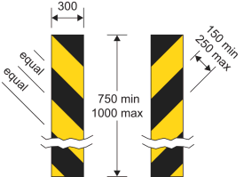 | 9 | ||
| 2 | Diagram 530A Maximum headroom available at hazard, with height indicated in both metric and imperial units |  | 1, 3, 4 or 5 | 6, 12 | |
| 3 | Diagram 531.1A Maximum headroom available at arch bridge ahead |  | 2 or 5 | 6, 12 | 3 |
| 4 | Diagram 1024.1 Road marking indicating path to be taken by high vehicles under a low bridge or to avoid an overhanging structure |  | 11, 13 | ||
| 5 | Diagram 629.2A Vehicles exceeding height indicated prohibited with height indicated in both metric and imperial units |  | 4 | 1, 2, 6, 12 |
PART 5Associated plates and structure warning markings for signs in Part 4
1.—(1) A warning or information of a description specified in column 2 of an item in the sign table in this Part must be conveyed by a plate or structure warning marking which is of the size, colour and type provided for—
(a)in the diagram in column 3 of the item; or
(b)in that diagram varied in accordance with column 4.
2. A provision of Part 7 mentioned (by reference to paragraph number) in column 5 of the sign table applies to the structure warning marking provided for at the item number in question.
Sign table — Schedule 2, Part 5
(1) Item | (2) Description | (3) Diagram | (4) Variants | (5) Applicable provisions in Part 7 |
|---|---|---|---|---|
| 1 | Diagram 530.1 Reduced headroom over part of road due to overhanging building or structure |  | 1. The legend may include— (a) a distance, with or without an arrow pointing to the left or to the right; (b) an arrow pointing to the left or to the right 2. “building” may be varied to “buildings” or “structure” | |
| 2 | Diagram 531.2 High vehicles to use middle of road at arch bridge ahead, |  | The legend may include an arrow pointing to the left or to the right | |
| 3 | Diagram 532.4 Upper: Extent of headroom available at the side of and in the centre of a road at an arch bridge. Lower: Marking highlighting reduced headroom at an arch bridge. |  | 1. The position and number of chord markings in the upper part of the diagram may be varied as appropriate 2. The black and yellow marking may be omitted | 7, 9 |
| 4 | Diagram 530.2 Reduced headroom at a hazard (Alternative types) |  | 7, 9 | |
| 5 | Diagram 572 Distance ahead to hazard |  | 1. The distance may be varied to another distance 2. The legend may include an arrow pointing to the left or to the right |
PART 6Other warning signs
1. A warning of a description in column 2 of the sign table in this Part must be conveyed by a sign that is—
(a)of the colour and type; and
(b)complies with the requirements as to size,
provided for in the diagram in column 3 of the sign table at the item number for that description, or that diagram as varied in accordance with column 4.
2. In the case of the description at item 1, the warning is to be conveyed by the triangular sign shown in the diagram and, depending on the warning to be conveyed, both associated plates shown in the diagram, or only the upper one, and paragraph 1 applies to each of those signs.
3. A provision of Part 7 mentioned (by reference to paragraph number) in column 5 applies to the sign, or combination, at the item number in question.
4. A Schedule 2 General Direction mentioned (by reference to paragraph number) in column 6 applies to the sign at the item number in question.
Sign table — Schedule 2, Part 6
(1) Item | (2) Description | (3) Diagram | (4) Variants | (5) Applicable provisions in Part 7 | (6) Schedule 2 General Directions |
|---|---|---|---|---|---|
| 1 | Diagram 501 Junction ahead controlled by a “GIVE WAY” or “STOP” sign, wherean indication may be given that the junction iswith a dual carriageway road |  | 1. In the upper plate “GIVE WAY” is varied to “STOP” if the stop sign is placed at a junction ahead 2. The lower associated plate may be omitted 3. In the upper plate the distance may be varied | 6 | 4 |
| 2 | Diagram 560 Edge of carriageway or obstruction near that edge (Alternative types) |  | 1. The colour of the circular sign or the rectangular sign may be varied to white or amber 2. The surface of the rectangular sign may be curved | 4 | 5 |
| 3 | Diagram 515 Sharp deviation of route |  | 1. The chevrons may be reversed to point to the right 2. The number of chevrons may be varied 3. The corners of the sign may be rounded, with a radius not greater than 10 mm 4. The sign may be formed of a series of vertical flexible elements that need not have a horizontal cross section that is flat, provided that the elements extend to ground level to form the support for the sign and the support is coloured black 5. Where vertical flexible elements are used, the horizontal distance between the pointed ends of two consecutive chevrons may be increased by up to 4% of the dimensions shown in the diagram 6. Where vertical flexible elements are used, a yellow border may be added to the outside edge of the part of the sign that comprises the chevrons 7. Where vertical flexible elements are used, the sign may include a white arrow on a blue circular background as shown by the diagram in column 3 at item 1 of the sign table in Part 2 of Schedule 3. This is to be placed over the chevrons and any yellow border, and formed as part of those elements | 8, 9 | |
| 4 | Diagram 774 Location of a railway or tramway level crossing without gate or barrier |  | |||
| 5 | Diagram 781 Load gauge giving audible warning to drivers where vehicles exceed safe height under electrified overhead cables |  | 1. The number of bells may be increased or decreased according to the width of the road over which the sign is placed 2. The bells may be of any colour, provided each bell is of the same colour | 10 | |
| 6 | Diagrams 789, 789.1, 789.2 Countdown markers to railway or tramway level crossing |  | Each sign may be reversed |
PART 7Provisions applicable to signs
1. Section 36 of the 1988 Act applies to the sign.
2. The sign is specified for the purposes of column 5 of the entry in Schedule 2 to the Road Traffic Offenders Act 1988(1) relating to offences under section 36 of the 1988 Act.
3. If the sign is displayed on a variable message sign and displays its aspects by means of light-emitting characters or symbols, the legend “SLOW DOWN” may be displayed beneath the sign (and any associated plates) in characters having a height of not less than one quarter of the height of the displayed sign.
4. The sign must be illuminated by means of retroreflecting material.
5. The safe height shown on the first associated plate must be between 1 foot 3 inches and 2 feet (380 mm to 600 mm) less than the height of the lowest part of the overhead wire, of which the sign gives warning, over the highest part of the surface of the carriageway beneath that wire.
6.—(1) Subject to sub paragraph (2), where the sign is placed on a road within 50 metres of any lamp which forms part of a system of street-lighting, the illumination requirements for the sign are—
(a)where that system of street-lighting is illuminated throughout the hours of darkness, the sign must be illuminated by internal or external lighting for so long as that system is illuminated and may also be reflectorised; or
(b)where that system of street-lighting is not illuminated throughout the hours of darkness—
(i)the sign must be illuminated by internal or external lighting for so long as that system is illuminated and must also be reflectorised; or
(ii)the sign must be illuminated throughout the hours of darkness by internal or external lighting and may also be reflectorised.
(2) Sub-paragraph (1) does not apply to a sign where the road is subject to a speed limit of 20 mph.
(3) The exception in sub-paragraph (2) does not apply to a sign provided for at item 2 or 5 of the Part 4 sign table mounted on a bridge or other structure and, consequently, sub-paragraph (1) applies to such a sign.
7. The structure warning marking may be left unlit, or be illuminated either by means of internal or external lighting or by means of retroreflecting material.
8. Paragraph 6 applies to that part of the sign, if any, which is the white arrow on a blue circular background.
9. Where those parts of the sign coloured yellow, if any, are retroreflective, they may also be fluorescent.
10. The sign must not be illuminated.
11. The road marking must be reflectorised.
12. The sign may have different numerals to those shown in the diagram.
13. The arrow in the road marking may indicate a path to the left instead of to the right.
PART 8The Schedule 2 General Directions
1. The triangular sign must not be placed unless placed with a plate showing the applicable first plate legend indicated in column 4 of the sign table in Part 2 at the item number in question.
2. The sign may be fitted to the rear of a road maintenance vehicle.
3. The two triangular signs must be placed together (with or without an associated plate).
4. The triangular sign must be placed with its upper associated plate (whether or not the lower plate is also included).
5.—(1) The sign (“an edge of carriageway sign”) must be placed so that the top of the sign is not less than 550 mm nor more than 1000 mm above the surface of the adjacent carriageway.
(2) Where an edge of carriageway sign is mounted on a post specifically provided for the purpose that part of the post which extends above ground level may be—
(a)of any single colour; or
(b)coloured black and white in alternate horizontal bands, each band being not less than 225 mm or more than 350 mm deep.
(3) An edge of carriageway sign must be erected to display—
(a)the colour red on the left hand edge of the carriageway as viewed by the drivers of approaching vehicles; and
(b)the colour white on the right hand edge of the carriageway when so viewed, unless the edge is the edge of the carriageway of a dual carriageway road or a one-way road when the colour amber must be displayed.
(1)
Options/Help
Print Options
Official printed copies
PrintThe Whole Instrument
PrintThis Schedule only
You have chosen to open The Whole Instrument
The Whole Instrument you have selected contains over 200 provisions and might take some time to download. You may also experience some issues with your browser, such as an alert box that a script is taking a long time to run.
Would you like to continue?
You have chosen to open The Whole Instrument as a PDF
The Whole Instrument you have selected contains over 200 provisions and might take some time to download.
Would you like to continue?
You have chosen to open the Whole Instrument
The Whole Instrument you have selected contains over 200 provisions and might take some time to download. You may also experience some issues with your browser, such as an alert box that a script is taking a long time to run.
Would you like to continue?
You have chosen to open Schedules only
The Schedules you have selected contains over 200 provisions and might take some time to download. You may also experience some issues with your browser, such as an alert box that a script is taking a long time to run.
Would you like to continue?

Legislation is available in different versions:
Latest Available (revised):The latest available updated version of the legislation incorporating changes made by subsequent legislation and applied by our editorial team. Changes we have not yet applied to the text, can be found in the ‘Changes to Legislation’ area.
Original (As Enacted or Made): The original version of the legislation as it stood when it was enacted or made. No changes have been applied to the text.
Opening Options
Different options to open legislation in order to view more content on screen at once
Explanatory Memorandum
Explanatory Memorandum sets out a brief statement of the purpose of a Statutory Instrument and provides information about its policy objective and policy implications. They aim to make the Statutory Instrument accessible to readers who are not legally qualified and accompany any Statutory Instrument or Draft Statutory Instrument laid before Parliament from June 2004 onwards.
More Resources
Access essential accompanying documents and information for this legislation item from this tab. Dependent on the legislation item being viewed this may include:
- the original print PDF of the as enacted version that was used for the print copy
- lists of changes made by and/or affecting this legislation item
- confers power and blanket amendment details
- all formats of all associated documents
- correction slips
- links to related legislation and further information resources
Impact Assessments
Impact Assessments generally accompany all UK Government interventions of a regulatory nature that affect the private sector, civil society organisations and public services. They apply regardless of whether the regulation originates from a domestic or international source and can accompany primary (Acts etc) and secondary legislation (SIs). An Impact Assessment allows those with an interest in the policy area to understand:
- Why the government is proposing to intervene;
- The main options the government is considering, and which one is preferred;
- How and to what extent new policies may impact on them; and,
- The estimated costs and benefits of proposed measures.
More Resources
Use this menu to access essential accompanying documents and information for this legislation item. Dependent on the legislation item being viewed this may include:
- the original print PDF of the as made version that was used for the print copy
- correction slips
Click 'View More' or select 'More Resources' tab for additional information including:
- lists of changes made by and/or affecting this legislation item
- confers power and blanket amendment details
- all formats of all associated documents
- links to related legislation and further information resources
 All content is available under the Open Government Licence v3.0 except where otherwise stated. This site additionally contains content derived from EUR-Lex, reused under the terms of the Commission Decision 2011/833/EU on the reuse of documents from the EU institutions. For more information see the EUR-Lex public statement on re-use.