Statutory Instruments
2019 No. 1179
Highways, England
The Worcestershire County Council (Carrington Bridge) Scheme 2018 Confirmation Instrument 2019
Made
24th July 2019
Coming into force in accordance with article 1
1. This Instrument may be cited as “The Worcestershire County Council (Carrington Bridge) Scheme 2018 Confirmation Instrument 2019” and shall come into force on the date on which notice that it has been confirmed is first published in accordance with paragraph 1 of Schedule 2 to the Highways Act 1980.
2. The Worcestershire County Council (Carrington Bridge) Scheme 2018 (“the Scheme”) is hereby confirmed with modifications.
3. The Scheme as confirmed is set out in the Schedule hereto (including the plans) and copies of the Scheme with its accompanying plans are deposited at the offices of the Department for Transport, Floor 13 (IMD), Ashdown House, St Leonards on Sea, Hastings, East Sussex, TN37 7GA and at the offices of the Council of Worcestershire County Council, Customer Service Centre, The Hive, Sawmill Walk, The Butts, Worcester, WR1 3PB and County Hall, Spetchley Road, Worcester, WR5 2NP.
Signed by authority of the Secretary of State for Transport
A Rhind
A Senior Civil Servant in the Department for Transport
24th July 2019
Regulation 3
THE SCHEDULETHE WORCESTERSHIRE COUNTY COUNCIL (CARRINGTON BRIDGE) SCHEME 2018
The Worcestershire County Council (hereinafter referred to as “the Council”) make this Scheme in exercise of their powers under Section 106 (3) of the Highways Act 1980 and of all other powers enabling them in that behalf:-
1. The Council are authorised to construct over the navigable waters of the River Severn the bridge specified in the Schedule to this Scheme as part of a highway they are proposing to construct/improve between the Ketch Roundabout and the Powick Roundabout in Worcester, Worcestershire.
2. This Scheme may be cited as The Worcestershire County Council (Carrington Bridge) Scheme 2018.
| Given under the common seal of the Council | |
| on the 1st day of February 2018 | |
| THE COMMON SEAL of | |
| WORCESTERSHIRE COUNTY COUNCIL | |
| was hereunto affixed in the presence of: | |
| C.S | |
| Senior Solicitor | |
Regulation 3
THE SCHEDULE TO THE SCHEME
PLANS AND SPECIFICATIONS OF THE CARRINGTON BRIDGE
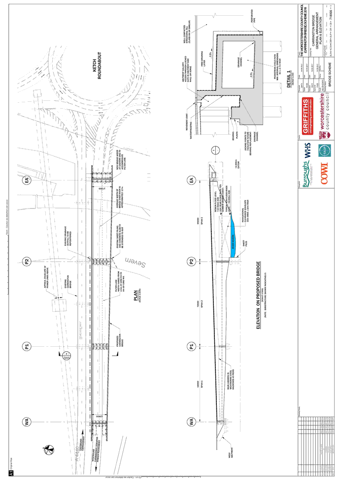
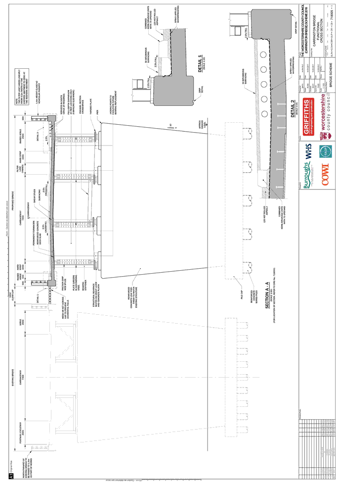
The location and general design of the bridge are shown on the plans numbered SLR4-COW-CBR-SUP-DR-CB-718000-5 and SLR4-COW-CBR-SUP-DR-CB-718005-5 sealed with the Common Seal of the Council and attached hereto.
POINTS OF COMMENCEMENT AND TERMINATION
The bridge is directly adjacent to the existing Carrington Bridge on the A4440 Temeside Way.
The bridge commences 50 metres to the west of the Ketch Roundabout and terminates 205 metres to the west, towards Powick.
SPAN
The bridge has a total span of 205m, comprising three spans of 69 metres, 72 metres and 64 metres, measured from east to west.
HEADWAY
Over the river the bridge will provide an air draft of not less than 10 metres above the typical (non-flood) water level of 8.00 metres AOD.
WATERWAY
A minimum clear navigable waterway of no less than 35 metres width to be maintained.
OVERALL DIMENSIONS
The bridge width varies from a minimum of approximately 13.5 metres at the western end to a maximum of approximately 18 metres at the eastern end. As shown on Section A-A (drawing SLR4-COW-CBR-SUP-DR-CB-781005-5), this width is made up of the following items (listed from north to south):
A 0.5 metre edge beam supporting a vehicular parapet
A 0.6 metre raised verge;
A 1 metre hard strip;
A 7.3 metre carriageway comprising two traffic lanes;
A filter lane of varying width (at the eastern end of the bridge this lane is approximately 4.5 metres wide, linearly tapering to zero metres wide at the western end of the bridge);
A 1 metre hard strip;
A 2.5 metre raised verge; and
A 0.5 metre edge beam supporting a vehicular parapet.
The average width of the bridge over the river is approximately 17 metres.
EXPLANATORY NOTE
(This note is not part of the Instrument)
This instrument confirms a Scheme that authorises the Council to construct over the navigable waters of the River Severn, the bridge specified in the Schedule to the Scheme as part of a highway they are proposing to construct between the Ketch Roundabout and the Powick Roundabout, Worcester in the County of Worcestershire.
The Secretary of State has modified this Bridge Scheme as follows:
1. In the Schedule to the Scheme, paragraph 1, the word ‘/improve’ has been added after ‘they are proposing to construct’.
2. In the Schedule to the Scheme, the first paragraph has been amended to ‘The location and general design of the bridge are shown on the plans numbered SLR4-COW-CBR-SUP-DR-CB-718000-5 and SLR4-COW-CBR-SUP-DR-CB-718005-5’.
3. In the Schedule to the Scheme, the paragraph titled ‘WATERWAY’, the words ‘A minimum clear’ has been added to before Navigable waterway.
4. In the Schedule to the Scheme, the paragraph titled ‘OVERALL DIMENSIONS’, the first paragraph has been amended to ‘As shown on Section A-A (drawing SLR4-COW-CBR-SUP-DR-CB-718005-5), this width is made up of the following items (listed from north to south).
5. The maps numbered SLR4-COW-CBR-SUP-DR-CB-718000_2 and SLR4-COW-CBR-SUP-DR-CB-718005_2 have been replaced by drawing number SLR4-COW-CBR-SUP-DR-CB-718000-5 and SLR4-COW-CBR-SUP-DR-CB-718005-5.