- Y Diweddaraf sydd Ar Gael (Diwygiedig)
- Gwreiddiol (a wnaed Fel)
The South Arran Marine Conservation Order 2015
You are here:
- Offerynnau Statudol yr Alban
- 2015 No. 437
- Whole Instrument
- Blaenorol
- Nesaf

Pa Fersiwn
Rhagor o Adnoddau
Status:
Dyma’r fersiwn wreiddiol (fel y’i gwnaed yn wreiddiol). This item of legislation is currently only available in its original format.
Scottish Statutory Instruments
2015 No. 437
Environmental Protection
Marine Management
The South Arran Marine Conservation Order 2015
Made
16th December 2015
Laid before the Scottish Parliament
18th December 2015
Coming into force
8th February 2016
The Scottish Ministers make the following Order in exercise of the powers conferred by sections 1 and 2A of the Inshore Fishing (Scotland) Act 1984(1), sections 85(1)(a), (2) and (4), 86(1) and (3), 88(1), (2) and (6) and 92(1) and (5) of the Marine (Scotland) Act 2010(2) and all other powers enabling them to do so.
In accordance with section 85(1)(a) of the Marine (Scotland) Act 2010, this Order is made for the purpose of furthering the stated conservation objectives for the South Arran Nature Conservation MPA(3).
In accordance with section 1(1) of the Inshore Fishing (Scotland) Act 1984, the Scottish Ministers have consulted such bodies as they considered appropriate.
In accordance with section 87(2) of the Marine (Scotland) Act 2010, the Scottish Ministers have sent a copy of a draft of this Order to persons whom they considered were likely to be interested in or affected by the making of this Order.
In accordance with section 87(3) of the Marine (Scotland) Act 2010, the Scottish Ministers have placed a copy of a draft of this Order in such place as they considered was likely to be most convenient for the purpose of enabling it to be inspected by persons likely to be affected by the making of this Order.
In accordance with section 87(6) and (7) of the Marine (Scotland) Act 2010, the Scottish Ministers have published notice of their proposal to make this Order.
Citation and commencement
1. This Order may be cited as the South Arran Marine Conservation Order 2015 and comes into force on 8th February 2016.
Interpretation
2. In this Order—
“boundary line” means a boundary delineated by a line as described in Schedule 1, 2 or 3;
“co-ordinate” means a co-ordinate of latitude and longitude according to the World Geodetic System 1984(4);
“the protected area” means the area described in article 3; and
“South Arran MPA” means the area designated as a nature conservation marine protected area by, and described in article 3 of, the South Arran Nature Conservation Marine Protected Area Order 2014(5).
The protected area
3. For the purposes of this Order, the area protected by it is—
(a)the seabed and subsoil; and
(b)all of the water covering the seabed,
within the South Arran MPA.
Prohibited and regulated activities
4.—(1) Paragraphs (2), (3), (4), (5), (6), (7), (8) and (10) apply in order to further the stated conservation objectives for the South Arran MPA.
(2) A person must not deploy (by any means) or use any fishing gear within the protected area.
(3) While a fishing vessel is within the protected area the master of the vessel must ensure that any fishing gear, passive gear, pelagic trawl, rod and line, or handline carried on board the vessel is properly lashed and stowed in such a way that it may not be readily used.
(4) Paragraphs (2) and (3) do not apply to the deployment or use of a demersal trawl (other than a beam trawl) by a vessel with a gross tonnage of no more than 120 tonnes, and registered as such under Part II of the Merchant Shipping Act 1995(6), within those parts of the protected area which are described in Schedule 1.
(5) A person must not deploy (by any means) or use any passive gear within those parts of the protected area which are described in Schedule 2.
(6) With regard to any passive gear, paragraph (3) only applies within those parts of the protected area which are described in Schedule 2.
(7) A person must not deploy (by any means) or use any pelagic trawl, rod and line, or handline within that part of the protected area which is described in Schedule 3.
(8) With regard to any pelagic trawl, rod and line, or handline, paragraph (3) only applies within that part of the protected area which is described in Schedule 3.
(9) Paragraphs (2), (3), (5), (6), (7) and (8) do not apply to the deployment or use of any fishing gear, passive gear, pelagic trawl, rod and line, or handline within the protected area for the purpose of saving life, or for the purpose of securing the safety of a vessel, aircraft or marine structure.
(10) A person must not fish by hand within that part of the protected area which is described in Schedule 3.
(11) In this article—
“beam trawl” means a type of demersal trawl which has its mouth extended by a beam, bar or other rigid device;
“creel” means a basket, small cage, pot, receptacle or container with one or more openings or entrances which may be baited and placed on the seabed for the purpose of catching fish or shellfish;
“demersal seine net” means an encircling net, attached to ropes, which is laid on, and towed across, the seabed;
“demersal trawl” means a net which is towed along the seabed;
“dredge” means—
(a)
a mechanical dredge; or
(b)
a suction dredge which raises material, fish and shellfish from the seabed by the use of a solids pump, air lift or water jets which dig into the seabed;
“fish by hand” means the catching, or collection, of fish or shellfish (or any attempt to catch or collect fish or shellfish) without the deployment or use of any fishing gear or any passive gear, pelagic trawl, rod and line, or handline;
“fishing gear” means any beam trawl, demersal seine net, demersal trawl, dredge, any other device used for fishing purposes, and any rope or wire associated with the gear but excluding–
(a)
passive gear;
(b)
a pelagic trawl;
(c)
a rod and line; and
(d)
a handline;
“handline” means a single fishing line which is held in a person’s hand;
“parlour creel” means a creel which has at least two compartments, entry to one or more of which is likely to be gained only through an internal connection from another compartment;
“passive gear” means any gear or catch operation which does not require an active movement of the gear, including—
(a)
gillnets, trammel nets and trap nets;
(b)
drifting gillnets, and drifting trammel nets, any of which may be equipped with anchoring, floating or navigational gear;
(c)
long lines and lines; and
(d)
creels and parlour creels,
and includes any rope or wire associated with the gear; and
“pelagic trawl” means any trawl or encircling net which has no contact with the seabed during a fishing operation, and includes any rope or wire associated with the gear.
Authorisation for the purpose of scientific research
5.—(1) The Scottish Ministers may, following written application to them, issue a permit authorising any of the following activities which would, apart from any such permit, be unlawful under this Order:—
(a)to deploy or use any fishing gear, passive gear, pelagic trawl, rod and line, or handline; and
(b)to fish by hand,
for the purpose of scientific research.
(2) The Scottish Ministers must not issue a permit unless they are satisfied that there is no significant risk of the activity hindering the achievement of the stated conservation objectives for the South Arran MPA.
(3) In this article “fishing gear”, “passive gear”, “pelagic trawl”, “handline” and “fish by hand” have the same meanings as in article 4(11).
Disapplication of exception to the offences under sections 94 and 95 of the Marine (Scotland) Act 2010
6.—(1) Paragraph (b) of section 97(1) of the 2010 Act does not apply in relation to—
(a)an offence under section 94 of the 2010 Act of contravening this Order;
(b)an offence under section 95 of the 2010 Act committed in relation to the protected area.
(2) In this article “the 2010 Act” means the Marine (Scotland) Act 2010.
Revocations
7. The instruments listed in column 1 of the table in Schedule 4 are revoked.
RICHARD LOCHHEAD
A member of the Scottish Government
St Andrew’s House,
Edinburgh
16th December 2015
Articles 2 and 4(4)
SCHEDULE 1AREAS WHERE DEMERSAL TRAWLING (OTHER THAN BEAM TRAWLING) BY SPECIFIED VESSELS IS ALLOWED
For the purposes of articles 2 and 4(4) the parts of the protected area described in this Schedule are enclosed by the boundary lines which are described below, in each case by reference to the co-ordinates of the points joined by a line and a topographical description of the line—
PART 1
| Boundary Line | Set of co-ordinates of points which the boundary line joins | Topographic description of boundary line |
|---|---|---|
| 1. | A to B | Geodesic line |
| 2. | B to C | Geodesic line |
| 3. | C to D | Geodesic line |
| 4. | D to E | Geodesic line |
| 5. | E to F | Geodesic line |
| 6. | F to A | Geodesic line |
Where—
“A” is 55°34.427′N, 005°02.341′W;
“B” is 55°34.479′N, 005°00.259′W;
“C” is 55°31.115′N, 004°58.162′W;
“D” is 55°28.697′N, 004°58.982′W;
“E” is 55°25.844′N, 005°00.291′W; and
“F” is 55°24.164′N, 005°02.281′W.
PART 2
| Boundary Line | Set of co-ordinates of points which the boundary line joins | Topographic description of boundary line |
|---|---|---|
| 1. | G to H | Geodesic line |
| 2. | H to I | Geodesic line |
| 3. | I to J | Geodesic line |
| 4. | J to K | Geodesic line |
| 5. | K to G | Geodesic line |
Where—
“G” is 55°24.164′N, 005°02.281′W;
“H” is 55°23.982′N, 005°02.496′W;
“I” is 55°22.824′N, 005°05.414′W;
“J” is 55°23.158′N, 005°13.914′W; and
“K” is 55°23.685′N, 005°17.506′W.
PART 3
| Boundary Line | Set of co-ordinates of points which the boundary line joins | Topographic description of boundary line |
|---|---|---|
| 1. | L to M | Geodesic line |
| 2. | M to N | Geodesic line |
| 3. | N to O | Geodesic line |
| 4. | O to L | Geodesic line |
Where—
“L” is 55°25.682′N, 005°22.576′W;
“M” is 55°28.648′N, 005°25.687′W;
“N” is 55°30.469′N, 005°26.702′W; and
“O” is 55°31.276′N, 005°22.853′W.
Articles 2 and 4(5) and (6)
SCHEDULE 2AREAS WHERE, IN ADDITION TO THE PROHIBITION ON THE DEPLOYMENT OR USE OF ANY FISHING GEAR, THE DEPLOYMENT OR USE OF ANY PASSIVE GEAR IS PROHIBITED
For the purposes of articles 2, 4(5) and (6) the parts of the protected area described in this Schedule are enclosed by the boundary lines which are described below, in each case by reference to the co-ordinates of the points joined by a line and a topographical description of the line—
PART 1
| Boundary Line | Set of co-ordinates of points which the boundary line joins | Topographical description of boundary line |
|---|---|---|
| 1. | P to Q | Geodesic line |
| 2. | Q to R | Mean high water spring tide |
| 3. | R to S | Geodesic line |
| 4. | S to T | Mean high water spring tide |
| 5. | T to U | Geodesic line |
| 6. | U to P | Mean high water spring tide |
Where—
“P” is 55°32.603′N, 005°06.512′W;
“Q” is 55°31.558′N, 005°05.218′W;
“R” is 55°31.876′N, 005°04.305′W;
“S” is 55°32.990′N, 005°04.839′W;
“T” is 55°32.998′N, 005°04.865′W; and
“U” is 55°33.002′N, 005°04.957′W.
PART 2
| Boundary Line | Set of co-ordinates of points which the boundary line joins | Topographical description of boundary line |
|---|---|---|
| 1. | V to W | Geodesic Line |
| 2. | W to X | Geodesic Line |
| 3. | X to Y | Geodesic Line |
| 4. | Y to Z | Geodesic Line |
| 5. | Z to AA | Geodesic Line |
| 6. | AA to AB | Geodesic Line |
| 7. | AB to AC | Geodesic Line |
| 8. | AC to AD | Geodesic Line |
| 9. | AD to AE | Geodesic Line |
| 10. | AE to AF | Geodesic Line |
| 11. | AF to AG | Geodesic Line |
| 12. | AG to AH | Geodesic Line |
| 13. | AH to AI | Geodesic Line |
| 14. | AI to AJ | Geodesic Line |
| 15. | AJ to V | Geodesic Line |
Where—
“V” is 55°30.584′N, 005°04.208′W;
“W” is 55°30.661′N, 005°04.110′W;
“X” is 55°30.618′N, 005°03.966′W;
“Y” is 55°30.826′N, 005°03.492′W;
“Z” is 55°30.943′N, 005°03.468′W;
“AA” is 55°30.989′N, 005°03.377′W;
“AB” is 55°30.916′N, 005°03.333′W;
“AC” is 55°30.621′N, 005°03.388′W;
“AD” is 55°30.539′N, 005°03.429′W;
“AE” is 55°30.276′N, 005°03.763′W;
“AF” is 55°30.193′N, 005°04.055′W ;
“AG” is 55°30.208′N, 005°04.083′W;
“AH” is 55°30.306′N, 005°04.077′W;
“AI” is 55°30.400′N, 005°04.040′W; and
“AJ” is 55°30.520′N, 005°04.080′W.
PART 3
| Boundary Line | Set of co-ordinates of points which the boundary line joins | Topographical description of boundary line |
|---|---|---|
| 1. | AK to AL | Geodesic line |
| 2. | AL to AM | Geodesic line |
| 3. | AM to AN | Geodesic line |
| 4. | AN to AO | Geodesic line |
| 5. | AO to AP | Geodesic line |
| 6. | AP to AQ | Geodesic line |
| 7. | AQ to AK | Mean high water spring tide |
Where—
“AK” is 55°30.403′N, 005°04.812′W;
“AL” is 55°30.035′N, 005°04.838′W;
“AM” is 55°29.650′N, 005°05.146′W;
“AN” is 55°29.177′N, 005°05.361′W;
“AO” is 55°28.567′N, 005°05.010′W;
“AP” is 55°28.039′N, 005°04.535′W; and
“AQ” is 55°27.914′N, 005°04.749′W.
PART 4
| Boundary Line | Set of co-ordinates of points which the boundary line joins | Topographical description of boundary line |
|---|---|---|
| 1. | AR to AS | Geodesic line |
| 2. | AS to AT | Geodesic line |
| 3. | AT to AU | Geodesic line |
| 4. | AU to AR | Geodesic line |
Where—
“AR” is 55°26.280′N, 005°07.860′W;
“AS” is 55°26.280′N, 005°06.060′W;
“AT” is 55°25.898′N, 005°06.080′W; and
“AU” is 55°25.908′N, 005°07.838′W.
PART 5
| Boundary Line | Set of co-ordinates of points which the boundary line joins | Topographical description of boundary line |
|---|---|---|
| 1. | AV to AW | Geodesic line |
| 2. | AW to AX | Geodesic line |
| 3. | AX to AY | Geodesic line |
| 4. | AY to AV | Geodesic line |
Where—
“AV” is 55°26.520′N, 005°18.660′W;
“AW” is 55°26.520′N, 005°17.220′W;
“AX” is 55°26.100′N, 005°17.220′W; and
“AY” is 55°26.176′N, 005°18.643′W.
Articles 2 and 4(7), (8) and (10)
SCHEDULE 3AREA WHERE, IN ADDITION TO THE PROHIBITION ON THE DEPLOYMENT OR USE OF ANY FISHING GEAR AND PASSIVE GEAR, THE DEPLOYMENT OR USE OF ANY PELAGIC TRAWL, ROD AND LINE, OR HANDLINE, AND FISHING BY HAND, IS PROHIBITED
For the purposes of articles 2, 4(7), (8) and (10) the part of the protected area described in this Schedule is enclosed by the boundary lines which are described below, in each case by reference to the co-ordinates of the points joined by a line and a topographical description of the line—
| Boundary Line | Set of co-ordinates of points which the boundary line joins | Topographical description of boundary line |
|---|---|---|
| 1. | P to Q | Geodesic line |
| 2. | Q to R | Mean high water spring tide |
| 3. | R to S | Geodesic line |
| 4. | S to T | Mean high water spring tide |
| 5. | T to U | Geodesic line |
| 6. | U to P | Mean high water spring tide |
Where—
“P” is 55°32.603′N, 005°06.512′W;
“Q” is 55°31.558′N, 005°05.218′W;
“R” is 55°31.876′N, 005°04.305′W;
“S” is 55°32.990′N, 005°04.839′W;
“T” is 55°32.998′N, 005°04.865′W; and
“U” is 55°33.002′N, 005°04.957′W.
Article 7
SCHEDULE 4Revocations
| Instrument | Citation |
|---|---|
| The Inshore Fishing (Prohibition on Fishing) (Lamlash Bay) (Scotland) Order 2008 | S.S.I. 2008/317 |
| The South Arran Marine Conservation Order 2014 | S.S.I. 2014/260 |
| The South Arran Marine Conservation (Amendment) Order 2014 | S.S.I. 2014/297 |
| The South Arran Marine Conservation Order 2014 (Urgent Continuation) Order 2015 | S.S.I. 2015/303 |
EXPLANATORY NOTE
(This note is not part of the Order)
Article 11(1) of Regulation (EU) No 1380/2013 of the European Parliament and of the Council on the Common Fisheries Policy (OJ L 354, 28.12.2013, p.22) empowers EU member States to adopt conservation measures which are necessary for compliance with obligations under EU environmental legislation.
The South Arran Nature Conservation Marine Protected Area Order 2014 (“the 2014 Order”) designated that part of the Scottish marine area which is adjacent to South Arran as a nature conservation marine protected area (“South Arran MPA”). The 2014 Order provides that a range of marine habitats and one low or limited mobility species are protected features.
This Order furthers the stated conservation objectives for the South Arran MPA.
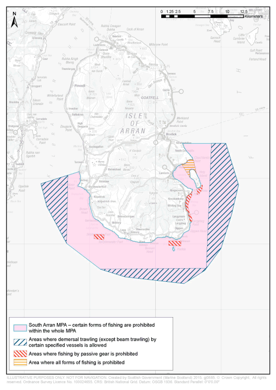
Article 3 describes the area protected by this Order (“the protected area”). It is the area which is designated under the 2014 Order as the South Arran MPA.
Article 4 prohibits and regulates activities within the protected area.
Article 4(2) provides that a person must not deploy or use any fishing gear within the protected area. The term “fishing gear” is defined in article 4(11) of the Order.
Article 4(3) regulates the storage of fishing gear, and other gear which is not covered by the general definition of fishing gear, on fishing vessels within the protected area.
Article 4(4) provides that demersal trawling (other than beam trawling) by certain specified fishing vessels is permitted within specified parts of the protected area which are described in Schedule 1.
Article 4(5) provides that a person must not deploy (by any means) or use passive gear within those parts of the protected area which are described in Schedule 2.
Article 4(7) provides that a person must not deploy (by any means) or use any pelagic trawl, rod and line, or a handline, within that part of the protected area which is described in Schedule 3.
Article 4(6) and (8) provide that article 4(3) applies with regard to the types of fishing provided for in article 4(5) and (7) only in those parts of the protected area where those types of fishing is not allowed.
Article 4(9) provides that certain specified provisions do not apply to activities carried out in the protected area for the purpose of saving life or for the purpose of securing the safety of a vessel, aircraft or marine structure.
Article 4(10) provides that a person may not fish other than by the deployment or use of fishing gear within the part of the protected area described in Schedule 3.
The effect of article 4(2), (3), (4), (5), (6), (7), (8) and (10) is that no fishing by any method may take place within the area in respect of which the Inshore Fishing (Prohibition on Fishing) (Lamlash Bay) (Scotland) Order 2008 (“the 2008 Order”) previously made provision.
Article 5 provides that the Scottish Ministers may issue permits authorising activity which would otherwise be unlawful under the Order within the protected area for the purpose of scientific research. The article makes provision regarding the procedure which applies to the making of applications for permits and the determination of such applications.
Article 6 provides that paragraph (b) of section 97(1) of the Marine (Scotland) Act 2010 does not apply in relation to an offence under section 94 of that Act of contravening this Order or an offence under section 95 of that Act committed in relation to the protected area.
Article 7 and Schedule 4 provide that the 2008 Order, the South Arran Marine Conservation Order 2014, the South Arran Marine Conservation (Amendment) Order 2014 and the South Arran Marine Conservation Order 2014 (Urgent Continuation) Order 2015 are revoked. The provision made by the 2008 Order and by the other Orders above is broadly re-made by this Order.
A person who contravenes this Order commits an offence and is liable on summary conviction to a fine of up to £50,000, and on conviction on indictment to an unlimited fine. The penalty on summary conviction under this Order is greater than that which is provided by the 2008 Order.
A business and regulatory impact assessment has been prepared in relation to this Order and placed in the Scottish Parliament Information Centre. A copy of this can be obtained from Marine Scotland, the Scottish Government, Victoria Quay, Edinburgh EH6 6QQ.
An illustrative map showing the South Arran MPA, and those parts of the MPA in respect of which the Order makes provision, is attached to this note.
(1)
1984 c.26. Section 1 was amended by the Inshore Fishing (Scotland) Act 1994 (c. 27), section 1 and by S.I. 1999/1820. Section 2A was inserted by the Environment Act 1995 (c.25), section 103(2). The functions of the Secretary of State were transferred to the Scottish Ministers by virtue of section 53 of the Scotland Act 1998 (c. 46).
(2)
(3)
The South Arran Nature Conservation MPA was designated by the South Arran Nature Conservation Marine Protected Area Order 2014 (“the 2014 Order”). The 2014 Order is available at http://www.gov.scot/Resource/0045/00456829.pdf. The conservation objectives are stated in article 5 of the 2014 Order and the protected features are stated in Schedule 2 to that Order.
(4)
The World Geodetic System 1984 is defined at paragraph 2.1 of the United States National Imagery and Mapping Agency Technical Report TR8350.2, third edition, amendment 1 of 3rd January 2000 entitled “Department of Defense World Geodetic System 1984” ( http://earth-info.nga.mil/GandG/publications/tr8350.2/wgs84fin.pdf)
(5)
The South Arran Nature Conservation Marine Protected Area Order 2014 (“the 2014 Order”) was made by the Scottish Ministers under powers within the Marine (Scotland) Act 2010, including section 67(1)(a). By virtue of section 165(3) of that Act the 2014 Order is not a Scottish statutory instrument but a Scottish Ministerial Order. The 2014 Order is available at http://www.gov.scot/Resource/0045/00456829.pdf
(6)
1995 c.21. Section 19(1) of the Merchant Shipping Act 1995 provides that the tonnage of any ship to be registered under Part II of that Act shall be ascertained in accordance with regulations made by the Secretary of State (“tonnage regulations”). The tonnage regulations are the Merchant Shipping (Tonnage) Regulations 1997 (S.I. 1997/1510) (as amended).
Options/Help
Print Options
PrintThe Whole Instrument

Mae deddfwriaeth ar gael mewn fersiynau gwahanol:
Y Diweddaraf sydd Ar Gael (diwygiedig):Y fersiwn ddiweddaraf sydd ar gael o’r ddeddfwriaeth yn cynnwys newidiadau a wnaed gan ddeddfwriaeth ddilynol ac wedi eu gweithredu gan ein tîm golygyddol. Gellir gweld y newidiadau nad ydym wedi eu gweithredu i’r testun eto yn yr ardal ‘Newidiadau i Ddeddfwriaeth’.
Gwreiddiol (Fel y’i Deddfwyd neu y’i Gwnaed): Mae'r wreiddiol fersiwn y ddeddfwriaeth fel ag yr oedd pan gafodd ei deddfu neu eu gwneud. Ni wnaed unrhyw newidiadau i’r testun.
Dewisiadau Agor
Dewisiadau gwahanol i agor deddfwriaeth er mwyn gweld rhagor o gynnwys ar y sgrin ar yr un pryd
Policy Note
Policy Note sets out a brief statement of the purpose of a Scottish Statutory Instrument and provides information about its policy objective and policy implications. They aim to make the Scottish Statutory Instrument accessible to readers who are not legally qualified and accompany any Scottish Statutory Instrument or Draft Scottish Statutory Instrument laid before the Scottish Parliament from July 2012 onwards. Prior to this date these type of notes existed as ‘Executive Notes’ and accompanied Scottish Statutory Instruments from July 2005 until July 2012.
Rhagor o Adnoddau
Gallwch wneud defnydd o ddogfennau atodol hanfodol a gwybodaeth ar gyfer yr eitem ddeddfwriaeth o’r tab hwn. Yn ddibynnol ar yr eitem ddeddfwriaeth sydd i’w gweld, gallai hyn gynnwys:
- y PDF print gwreiddiol y fel deddfwyd fersiwn a ddefnyddiwyd am y copi print
- rhestr o newidiadau a wnaed gan a/neu yn effeithio ar yr eitem hon o ddeddfwriaeth
- manylion rhoi grym a newid cyffredinol
- pob fformat o’r holl ddogfennau cysylltiedig
- slipiau cywiro
- dolenni i ddeddfwriaeth gysylltiedig ac adnoddau gwybodaeth eraill
Rhagor o Adnoddau
Defnyddiwch y ddewislen hon i agor dogfennau hanfodol sy’n cyd-fynd â’r ddeddfwriaeth a gwybodaeth am yr eitem hon o ddeddfwriaeth. Gan ddibynnu ar yr eitem o ddeddfwriaeth sy’n cael ei gweld gall hyn gynnwys:
- y PDF print gwreiddiol y fel gwnaed fersiwn a ddefnyddiwyd am y copi print
- slipiau cywiro
liciwch ‘Gweld Mwy’ neu ddewis ‘Rhagor o Adnoddau’ am wybodaeth ychwanegol gan gynnwys
- rhestr o newidiadau a wnaed gan a/neu yn effeithio ar yr eitem hon o ddeddfwriaeth
- manylion rhoi grym a newid cyffredinol
- pob fformat o’r holl ddogfennau cysylltiedig
- dolenni i ddeddfwriaeth gysylltiedig ac adnoddau gwybodaeth eraill
 Mae’r holl gynnwys ar gael dan Drwydded Llywodraeth Agored v3.0 ac eithrio ble nodir yn wahanol. Yn ychwanegol mae’r safle hwn â chynnwys sy’n deillio o EUR-Lex, a ailddefnyddiwyd dan delerau Penderfyniad y Comisiwn 2011/833/EU ar ailddefnyddio dogfennau o sefydliadau’r UE. Am ragor o wybodaeth gweler ddatganiad cyhoeddus Swyddfa Gyhoeddiadau’r UE ar ailddefnyddio.