- Y Diweddaraf sydd Ar Gael (Diwygiedig)
- Gwreiddiol (a wnaed Fel)
The Croydon, Lambeth and Southwark (London Borough Boundaries) Order 1993
You are here:
- Offerynnau Statudol y Deyrnas Unedig
- 1993 No. 1147
- Whole Instrument
- Blaenorol
- Nesaf

Pa Fersiwn
Dewisiadau Agor
Rhagor o Adnoddau
Status:
Dyma’r fersiwn wreiddiol (fel y’i gwnaed yn wreiddiol). This item of legislation is currently only available in its original format.
Statutory Instruments
1993 No. 1147
LOCAL GOVERNMENT, ENGLAND AND WALES
CHANGES IN LOCAL GOVERNMENT AREAS
The Croydon, Lambeth and Southwark (London Borough Boundaries) Order 1993
Made
23rd April 1993
Laid before Parliament
4th May 1993
Coming into force
for the purposes referred to in article 1(2)
1st December 1993
for all other purposes
1st April 1994
The Secretary of State, in exercise of his powers under sections 51(2) and 67(4) of the Local Government Act 1972(1) and of all other powers enabling him in that behalf, hereby makes the following Order which gives effect to proposals submitted to him under sections 47, 48(1) and 51(1) of that Act, more than six weeks before the making of this Order, by the local Government Boundary Commission for England:
Citation and commencement
1.—(1) This Order may be cited as the Croydon, Lambeth and Southwark (London Borough Boundaries) Order 1993.
(2) This Order shall come into force on 1st December 1993 for any purpose set out in regulation 4(1) of the Local Government Area Changes Regulations 1976(2).
(3) For all other purposes, this Order shall come into force on 1st April 1994.
Interpretation
2. In this Orderany reference to Croydon, Lambeth or Southwark is a reference to the London borough of that name;
“the map” means one of the 9 maps prepared by the Department of the Environment, marked “Maps of the Croydon, Lambeth and Southwark (London Borough Boundaries) Order 1993”, duly numbered for reference, and deposited in accordance with regulation 5 of the Local Government Area Changes Regulations 1976;
and any reference to a ward is a reference to a ward of the London borough from or to which an area is transferred.
Transfers between Croydon and Lambeth
3.—(1) The following areas of Croydon
(i)the parts of Norbury ward marked B on map 9, A and C on map 8, A on map 7 and C on map 6; and
(ii)the parts of Upper Norwood ward marked A and B on map 5 shall be transferred to Lambeth, to the Streatham South ward, to the South Western petty sessional division, and to the Inner South London coroner’s district.
(2) The areas marked A and C on map 9, B on map 8, and A and B on map 6 shall be transferred from Lambeth, and from the Streatham South ward to Croydon, to the Norbury ward, to the Croydon petty sessional area, and to the Southern London coroner’s district.
Transfers between Lambeth and Southwark
4.—(1) Each area which is marked as shown in column 1 of the following Table on the map indicated in column 2 shall be transferred from Lambeth, and from the ward named in column 3 to Southwark, to the ward named in column 4.
TABLE
| (1) | (2) | (3) | (4) |
|---|---|---|---|
| Area marked | On map | Transferred from Lambeth, and from the following ward | To Southwark, and to the following ward |
| A | 2 | Prince's | Browning |
| B & D | 3 | Vassall | Newington |
| E | 3 | Vassall | Faraday |
| F | 3 | Vassall | St Giles |
(2) The areas marked A, B and C on map 1, and A on map 4 shall be transferred from Southwark, and from the Cathedral ward to Lambeth, and to the Bishop’s ward.
(3) The areas marked A and C on map 3 shall be transferred from Southwark, and from the Newington ward to Lambeth, and to the Vassall ward.
Town and country planning
5.—(1) In this article, “provision” means a provision of a development plan as defined in section 336 of the Town and Country Planning Act 1990(3).
(2) Any provision applying to an area transferred by this Order shall continue to apply to that area, notwithstanding the transfer, until replaced by a provision which so applies, and which is expressed to supersede the preserved provision.
Signed by authority of the Secretary of State for the Environment
Robin Squire
Parliamentary Under Secretary of State,
Department of the Environment
23rd April 1993
Explanatory Note
(This note is not part of the Order)
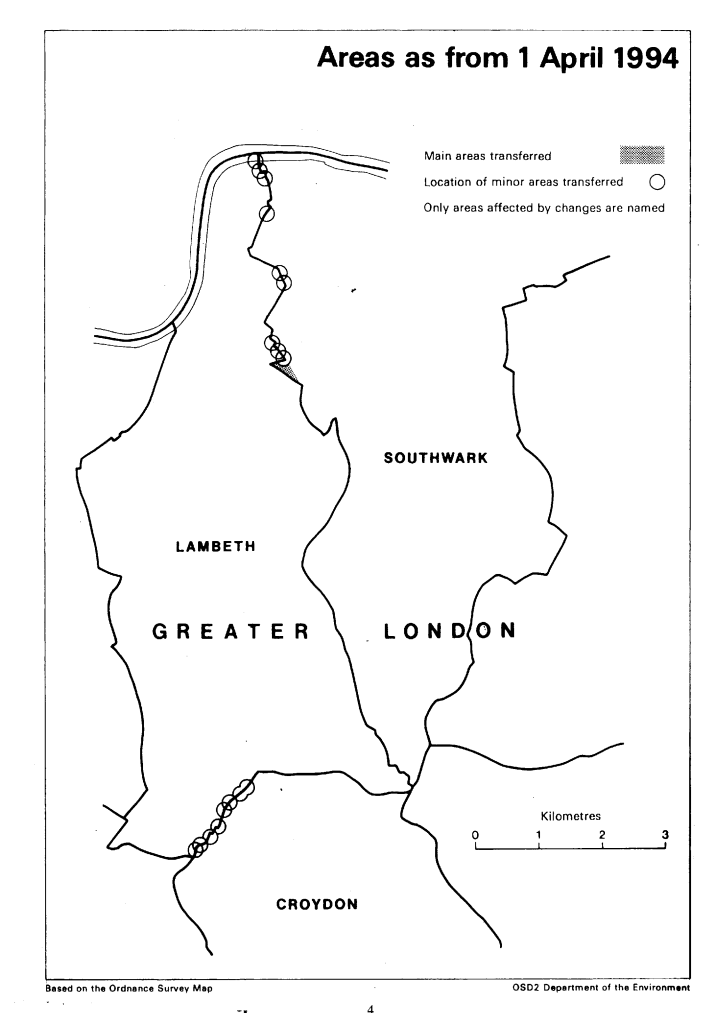
This Order makes changes to the boundary between—
(a)the London boroughs of Croydon and Lambeth (affecting the Croydon wards of Norbury and Upper Norwood and the Lambeth ward of Streatham South); and
(b)the London boroughs of Lambeth and Southwark (affecting the Lambeth wards of Bishop's, Prince’s and Vassall, and the Southwark wards of Browning, Cathedral, Faraday, Newington and St Giles).
The map and table at the end of this Note give a general guide to the areas affected and the changes made.
The table also gives an approximate figure for the total area of land involved (in hectares) and for the population affected.
For full details of the transfers made, the order maps (described in article 2) should be inspected.
Any person may inspect them at any reasonable time at the offices of the council for each metropolitan borough or city affected, and also at the offices of the Secretary of State for the Environment located in 2, Marsham Street, London SW1P 3EB.
The Local Government Area Changes Regulations 1976 (S. I. 1976/246, amended by S. I. 1978/247) contain general provisions regarding the effect of orders such as this one.
TABLE
| Transfers between— | Location of main transfers |
|---|---|
| Croydon and Lambeth (Article 3) Area: 1 hectare and Population: 20 | Realignment of boundary in vicinity of— (a) Woodmansterne Road; (b) Streatham High Road/Hermitage Lane; (c) Briar Avenue/Strathbrook Road; (d) Covington Way/The Rookery/Streatham Common |
| Lambeth and Southwark (Article 4) | Transfer to Southwark of area in vicinity of Dante Road, including Hollyoak Road. |
| Area: 10 hectares | Realignment in Kennington Park Gardens/Headcroft Road area, including transfer of St Agnes' Church to Southwark. |
| Population: 830 | Transfer to Southwark of large area bounded in the north by Hillingdon Street and Bolton Crescent, in the west by Camberwell New Road, in the east by Farmers Road and in the south by Wyndham Road. |
| Transfer to Lambeth of area west of Hatfield to unite London Nautical School and Hatfield Gardens in that borough. | |
| Transfer to Lambeth of area west of Pontypool Place in the vicinity of Quentin House. |
(1)
(3)
1990 c. 8. This definition was amended by the Planning and Compensation Act 1991 (c. 34), Schedule 4, para. 34.
Options/Help
Print Options
PrintThe Whole Instrument

Mae deddfwriaeth ar gael mewn fersiynau gwahanol:
Y Diweddaraf sydd Ar Gael (diwygiedig):Y fersiwn ddiweddaraf sydd ar gael o’r ddeddfwriaeth yn cynnwys newidiadau a wnaed gan ddeddfwriaeth ddilynol ac wedi eu gweithredu gan ein tîm golygyddol. Gellir gweld y newidiadau nad ydym wedi eu gweithredu i’r testun eto yn yr ardal ‘Newidiadau i Ddeddfwriaeth’.
Gwreiddiol (Fel y’i Deddfwyd neu y’i Gwnaed): Mae'r wreiddiol fersiwn y ddeddfwriaeth fel ag yr oedd pan gafodd ei deddfu neu eu gwneud. Ni wnaed unrhyw newidiadau i’r testun.
Dewisiadau Agor
Dewisiadau gwahanol i agor deddfwriaeth er mwyn gweld rhagor o gynnwys ar y sgrin ar yr un pryd
Rhagor o Adnoddau
Gallwch wneud defnydd o ddogfennau atodol hanfodol a gwybodaeth ar gyfer yr eitem ddeddfwriaeth o’r tab hwn. Yn ddibynnol ar yr eitem ddeddfwriaeth sydd i’w gweld, gallai hyn gynnwys:
- y PDF print gwreiddiol y fel deddfwyd fersiwn a ddefnyddiwyd am y copi print
- rhestr o newidiadau a wnaed gan a/neu yn effeithio ar yr eitem hon o ddeddfwriaeth
- manylion rhoi grym a newid cyffredinol
- pob fformat o’r holl ddogfennau cysylltiedig
- slipiau cywiro
- dolenni i ddeddfwriaeth gysylltiedig ac adnoddau gwybodaeth eraill
 Mae’r holl gynnwys ar gael dan Drwydded Llywodraeth Agored v3.0 ac eithrio ble nodir yn wahanol. Yn ychwanegol mae’r safle hwn â chynnwys sy’n deillio o EUR-Lex, a ailddefnyddiwyd dan delerau Penderfyniad y Comisiwn 2011/833/EU ar ailddefnyddio dogfennau o sefydliadau’r UE. Am ragor o wybodaeth gweler ddatganiad cyhoeddus Swyddfa Gyhoeddiadau’r UE ar ailddefnyddio.