- Latest available (Revised)
- Original (As made)
The A564 Trunk Road (Stoke—Derby Route) (Derby Southern Bypass and Slip Roads) (No. 2) Order 1992
You are here:
- UK Statutory Instruments
- 1992 No. 176
- Schedules only

What Version
More Resources
Status:
This is the original version (as it was originally made). This item of legislation is currently only available in its original format.
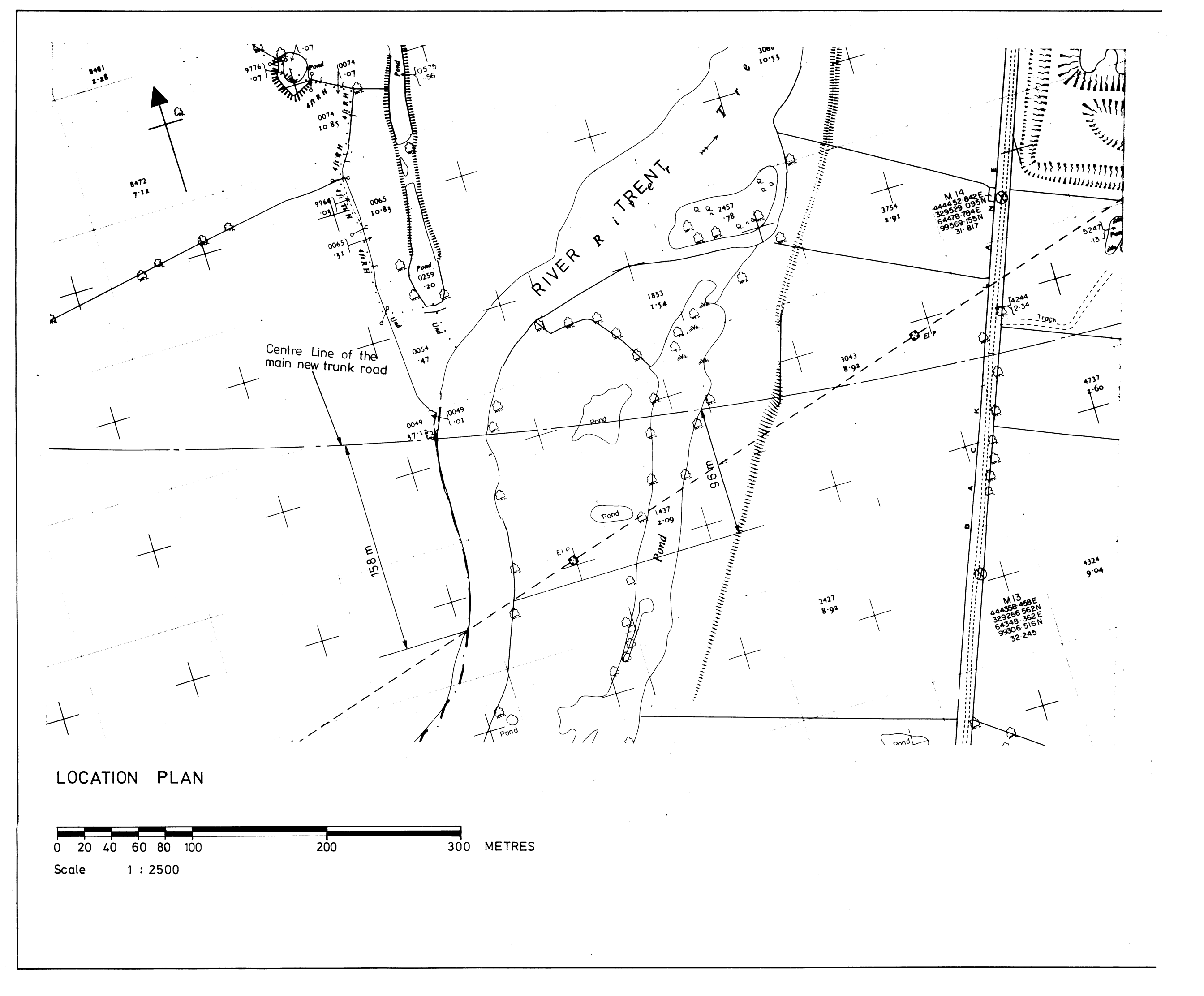
SCHEDULE 1ROUTE OF THE MAIN NEW TRUNK ROAD
The route of the mainnew trunk road is in the parishes of Swarkestone, Aston-upon-Trent and Shardlow and Great Wilne, in the County of Derbyshire, and of Castle Donington, and Lockington-Hemington in the County of Leicestershire. It is about 8.83 kilometres in length starting at a point on the A514 (Swarkestone Road) measured in a straight line on a horizontal plane 150 metres south-west of the southern boundary of the property known as Windmill Cottage,. This point is given the reference letter `B' on the deposited plan.
The route then heads in a generally north-easterly direction crossing Chellaston Lane at Aston-upon-Trent and curves eastward to cross the Derby Road, Aston-on-Trent north-east of Brickyard Plantation. It continues in a south-easterly direction and crosses Aston Lane and the Trent and Mersey Canal east of Hickens Bridge where a new bridge as described in Schedule 3 to this Order will be constructed; then in an easterly direction to cross the River Trent north of the point where the high voltage electricity cables cross the river, where a new bridge as described in Schedule 4 will be constructed. The route then crosses Back Lane south of Cavendish Bridge, Donington Lane and the B6540, and terminates at a point on the A6 Trunk Road about 470 metres north of its junction with Netherfield Lane. This point is given the reference letter`C' on the deposited plan.
SCHEDULE 2ROUTES OF THE SLIP ROADS
(a)
Junction with the A514 (Swarkestone Road) near Swarkestone
(i)
A route to connect the north-east side of the roundabout to be constructed by the Secretary of State in pursuance of the (No. 1) Order with the eastbound carriageway of the main new trunk road. This route is given the reference number 1 on the deposited plan.
(ii)
A route to connect the westbound carriageway of the main new trunk road with the south-east side of the said roundabout. This route is given the reference number 2 on the deposited plan.
(b)
Junction with the B6540 (Tamworth Road) and the A6 Trunk Road, near Lockington
(i)
A roundabout, the centre of which is at a point measured in a straight line on a horizontal plane 220 metres south of the centre of the roundabout at the junction of the A6 Trunk Road with the B6540 Tamworth Road. This route is given the reference number 3 on the deposited plan.
(ii)
A route to connect the eastbound carriageway of the main new trunk road with the north-west side of the route described at (b)(i) above. This route is given the reference number 4 on the deposited plan.
(iii)
A route to connect the north-east side of the route described at (b)(i) above with the A6 Trunk Road about 470 metres north-west of its junction with Netherfield Lane. This route is given the reference number 5 on the deposited plan.
(iv)
A route to connect the northbound carriageway of the A6 Trunk Road with the south-east side of the route described at (b)(i) above. This route is given the reference number 6 on the deposited plan.
(v)
A route to connect the south-west side of the route described at (b)(i) above with the westbound carriageway of the main new trunk road. This route is given the reference number 7 on the deposited plan.


Options/Help
Print Options
PrintThe Whole Instrument
PrintThe Schedules only

Legislation is available in different versions:
Latest Available (revised):The latest available updated version of the legislation incorporating changes made by subsequent legislation and applied by our editorial team. Changes we have not yet applied to the text, can be found in the ‘Changes to Legislation’ area.
Original (As Enacted or Made): The original version of the legislation as it stood when it was enacted or made. No changes have been applied to the text.
Opening Options
Different options to open legislation in order to view more content on screen at once
More Resources
Access essential accompanying documents and information for this legislation item from this tab. Dependent on the legislation item being viewed this may include:
- the original print PDF of the as enacted version that was used for the print copy
- lists of changes made by and/or affecting this legislation item
- confers power and blanket amendment details
- all formats of all associated documents
- correction slips
- links to related legislation and further information resources
 All content is available under the Open Government Licence v3.0 except where otherwise stated. This site additionally contains content derived from EUR-Lex, reused under the terms of the Commission Decision 2011/833/EU on the reuse of documents from the EU institutions. For more information see the EUR-Lex public statement on re-use.