- Latest available (Revised)
- Point in Time (11/03/2009)
- Original (As adopted by EU)
Regulation (EC) No 217/2009 of the European Parliament and of the CouncilShow full title
Regulation (EC) No 217/2009 of the European Parliament and of the Council of 11 March 2009 on the submission of catch and activity statistics by Member States fishing in the north-west Atlantic (recast) (Text with EEA relevance)
You are here:
- Regulations originating from the EU
- 2009 No. 217
- Annexes only

What Version
Advanced Features
- Show Geographical Extent(e.g. England, Wales, Scotland and Northern Ireland)
- Show Timeline of Changes
More Resources
Revised version PDFs
- Revised 10/01/20141.96 MB
- Revised 01/07/20131.49 MB
Legislation originating from the EU
When the UK left the EU, legislation.gov.uk published EU legislation that had been published by the EU up to IP completion day (31 December 2020 11.00 p.m.). On legislation.gov.uk, these items of legislation are kept up-to-date with any amendments made by the UK since then.


This item of legislation originated from the EU
Legislation.gov.uk publishes the UK version. EUR-Lex publishes the EU version. The EU Exit Web Archive holds a snapshot of EUR-Lex’s version from IP completion day (31 December 2020 11.00 p.m.).
Changes over time for: Regulation (EC) No 217/2009 of the European Parliament and of the Council (Annexes only)
Version Superseded: 01/07/2013
Alternative versions:
Status:
Point in time view as at 11/03/2009.
Changes to legislation:
There are currently no known outstanding effects for the Regulation (EC) No 217/2009 of the European Parliament and of the Council.
Changes to Legislation
Revised legislation carried on this site may not be fully up to date. At the current time any known changes or effects made by subsequent legislation have been applied to the text of the legislation you are viewing by the editorial team. Please see ‘Frequently Asked Questions’ for details regarding the timescales for which new effects are identified and recorded on this site.
ANNEX IU.K.LIST OF SPECIES WHICH HAVE BEEN REPORTED IN THE COMMERCIAL CATCH STATISTICS FOR THE NORTH-WEST ATLANTIC
Member States must report the nominal catches of those species marked with an asterisk (*). The reporting of nominal catches of the remaining species is optional as concerns the identification of the individual species. However, where data for individual species are not submitted the data shall be included in aggregate categories. Member States may submit data for species not in the list provided that the species are clearly identified.
Note
:
‘n.e.i.’ is the abbreviation for ‘not elsewhere identified’.
| English name | 3-alpha identifier | Scientific name |
|---|---|---|
| GROUNDFISH | ||
| Atlantic cod | COD (*) | Gadus morhua |
| Haddock | HAD (*) | Melanogrammus aeglefinus |
| Atlantic redfishes n.e.i. | RED (*) | Sebastes spp. |
| Silver hake | HKS (*) | Merluccius bilinearis |
| Red hake | HKR (*) | Urophycis chuss |
| Saithe (= pollock) | POK (*) | Pollachius virens |
| Golden redfish | REG (*) | Sebastes marinus |
| Beaked redfish | REB (*) | Sebastes mentella |
| American plaice (L. R. dab) | PLA (*) | Hippoglossoides platessoides |
| Witch flounder | WIT | Glyptocephalus cynoglossus |
| Yellowtail flounder | YEL (*) | Limanda ferruginea |
| Greenland halibut | GHL (*) | Reinhardtius hippoglossoides |
| Atlantic halibut | HAL (*) | Hippoglossus hippoglossus |
| Winter flounder | FLW (*) | Pseudopleuronectes americanus |
| Summer flounder | FLS (*) | Paralichthys dentatus |
| Windowpane flounder | FLD (*) | Scophthalmus aquosus |
| Flatfishes n.e.i. | FLX | Pleuronectiformes |
| American angler | ANG (*) | Lophius americanus |
| Atlantic searobins | SRA | Prionotus spp. |
| Atlantic tomcod | TOM | Microgadus tomcod |
| Blue antimora | ANT | Antimora rostrata |
| Blue whiting (= poutassou) | WHB | Micromesistius poutassou |
| Cunner | CUN | Tautogolabrus adspersus |
| Cusk (= tusk) | USK | Brosme brosme |
| Greenland cod | GRC | Gadus ogac |
| Blue ling | BLI | Molva dypterygia |
| Ling | LIN (*) | Molva molva |
| Lumpfish (= lumpsucker) | LUM (*) | Cyclopterus lumpus |
| Northern kingfish | KGF | Menticirrhus saxatilis |
| Northern puffer | PUF | Sphoeroides maculatus |
| Eelpouts n.e.i. | ELZ | Lycodes spp. |
| Ocean pout | OPT | Zoarces americanus |
| Polar cod | POC | Boreogadus saida |
| Roundnose grenadier | RNG | Coryphaenoides rupestris |
| Roughhead grenadier | RHG | Macrourus berglax |
| Sandeels (= sand lances) | SAN | Ammodytes spp. |
| Sculpins n.e.i. | SCU | Myoxocephalus spp. |
| Scup | SCP | Stenotomus chrysops |
| Tautog | TAU | Tautoga onitis |
| Tilefish | TIL | Lopholatilus chamaeleonticeps |
| White hake | HKW (*) | Urophycis tenuis |
| Wolf-fishes n.e.i. | CAT (*) | Anarhichas spp. |
| Atlantic wolf-fish | CAA (*) | Anarhichas lupus |
| Spotted wolf-fish | CAS (*) | Anarhichas minor |
| Groundfishes n.e.i. | GRO | Osteichthyes |
| PELAGIC FISH | ||
| Atlantic herring | HER (*) | Clupea harengus |
| Atlantic mackerel | MAC (*) | Scomber scombrus |
| Atlantic butterfish | BUT | Peprilus triacanthus |
| Atlantic menhaden | MHA (*) | Brevoortia tyrannus |
| Atlantic saury | SAU | Scomberesox saurus |
| Bay anchovy | ANB | Anchoa mitchilli |
| Bluefish | BLU | Pomatomus saltatrix |
| Crevalle Jack | CVJ | Caranx hippos |
| Frigate tuna | FRI | Auxis thazard |
| King mackerel | KGM | Scomberomorus cavalla |
| Atlantic Spanish mackerel | SSM (*) | Scomberomorus maculatus |
| Sailfish | SAI | Istiophorus albicans |
| White marlin | WHM | Tetrapturus albidus |
| Blue marlin | BUM | Makaira nigricans |
| Swordfish | SWO | Xiphias gladius |
| Albacore tuna | ALB | Thunnus alalunga |
| Atlantic bonito | BON | Sarda sarda |
| Little tunny | LTA | Euthynnus alletteratus |
| Bigeye tuna | BET | Thunnus obesus |
| Northern bluefish tuna | BFT | Thunnus thynnus |
| Skipjack tuna | SKJ | Katsuwonus pelamis |
| Yellowfin tuna | YFT | Thunnus albacares |
| Tunas n.e.i. | TUN | Thunnini |
| Pelagic fishes n.e.i. | PEL | Osteichthyes |
| OTHER FIN FISH | ||
| Alewife | ALE | Alosa pseudoharengus |
| Amberjacks n.e.i. | AMX | Seriola spp. |
| American conger | COA | Conger oceanicus |
| American eel | ELA | Anguilla rostrata |
| American shad | SHA | Alosa sapidissima |
| Argentines n.e.i. | ARG | Argentina spp. |
| Atlantic croaker | CKA | Micropogonias undulatus |
| Atlantic needlefish | NFA | Strongylura marina |
| Atlantic thread herring | THA | Opisthonema oglinum |
| Baird's slickhead | ALC | Alepocephalus bairdii |
| Black drum | BDM | Pogonias cromis |
| Black sea bass | BSB | Centropristis striata |
| Blueback herring | BBH | Alosa aestivalis |
| Capelin | CAP (*) | Mallotus villosus |
| Char n.e.i. | CHR | Salvelinus spp. |
| Cobia | CBA | Rachycentron canadum |
| Common (= Florida) pompano | POM | Trachinotus carolinus |
| Gizzard shad | SHG | Dorosoma cepedianum |
| Grunts n.e.i. | GRX | Haemulidae |
| Hickory shad | SHH | Alosa mediocris |
| Lanternfish | LAX | Notoscopelus spp. |
| Mullets n.e.i. | MUL | Mugilidae |
| North Atlantic harvestfish | HVF | Peprilus alepidotus |
| Pigfish | PIG | Orthopristis chrysoptera |
| Rainbow smelt | SMR | Osmerus mordax |
| Red drum | RDM | Sciaenops ocellatus |
| Red porgy | RPG | Pagrus pagrus |
| Rough shad | RSC | Trachurus lathami |
| Sand perch | PES | Diplectrum formosum |
| Sheepshead | SPH | Archosargus probatocephalus |
| Spot croaker | SPT | Leiostomus xanthurus |
| Spotted weakfish | SWF | Cynoscion nebulosus |
| Squeteague | STG | Cynoscion regalis |
| Striped bass | STB | Morone saxatilis |
| Sturgeons n.e.i. | STU | Acipenseridae |
| Tarpon | TAR | Megalops atlanticus |
| Trout n.e.i. | TRO | Salmo spp. |
| White perch | PEW | Morone americana |
| Alfonsinos | ALF | Beryx spp. |
| Spiny (= piked) dogfish | DGS (*) | Squalus acanthias |
| Dogfishes n.e.i. | DGX (*) | Squalidae |
| Porbeagle | POR (*) | Lamna nasus |
| Large sharks n.e.i. | SHX | Squaliformes |
| Shortfin mako shark | SMA | Isurus oxyrinchus |
| Atlantic sharpnose shark | RHT | Rhizoprionodon terraenovae |
| Black dogfish | CFB | Centroscyllium fabricii |
| Boreal (Greenland) shark | GSK | Somniosus microcephalus |
| Basking shark | BSK | Cetorhinus maximus |
| Little skate | RJD | Leucoraja erinacea |
| Barndoor skate | RJL | Dipturus laevis |
| Winter skate | RJT | Leucoraja ocellata |
| Thorny skate | RJR | Amblyraja radiata |
| Smooth skate | RJS | Malacoraja senta |
| Spinytail (spinetail) skate | RJQ | Bathyraja spinicauda |
| Arctic skate | RJG | Amblyraja hyperborea |
| Skates n.e.i. | SKA (*) | Raja spp. |
| Finfishes n.e.i. | FIN | Osteichthyes |
| INVERTEBRATES | ||
| Long-finned squid | SQL (*) | Loligo pealeii |
| Short-finned squid | SQI (*) | Illex illecebrosus |
| Squids n.e.i. | SQU (*) | Loliginidae, Ommastrephidae |
| Atlantic razor clam | CLR | Ensis directus |
| Hard clam | CLH | Mercenaria mercenaria |
| Ocean quahog | CLQ | Arctica islandica |
| Soft clam | CLS | Mya arenaria |
| Surf clam | CLB | Spisula solidissima |
| Clams n.e.i. | CLX | Bivalvia |
| Bay scallop | SCB | Argopecten irradians |
| Calico scallop | SCC | Argopecten gibbus |
| Icelandic scallop | ISC | Chlamys islandica |
| Sea scallop | SCA | Placopecten magellanicus |
| Scallops n.e.i. | SCX | Pectinidae |
| American cupped oyster | OYA | Crassostrea virginica |
| Blue mussel | MUS | Mytilus edulis |
| Whelks n.e.i. | WHX | Busycon spp. |
| Periwinkles n.e.i. | PER | Littorina spp. |
| Marine molluscs n.e.i. | MOL | Mollusca |
| Atlantic rock crab | CRK | Cancer irroratus |
| Blue crab | CRB | Callinectes sapidus |
| Green crab | CRG | Carcinus maenas |
| Jonah crab | CRJ | Cancer borealis |
| Queen crab | CRQ | Chionoecetes opilio |
| Red crab | CRR | Geryon quinquedens |
| Stone king crab | KCT | Lithodes maja |
| Marine crabs n.e.i. | CRA | Brachyura |
| American lobster | LBA | Homarus americanus |
| Northern prawn | PRA (*) | Pandalus borealis |
| Aesop shrimp | AES | Pandalus montagui |
| Penaeus shrimps n.e.i. | PEN (*) | Penaeus spp. |
| Pink (= pandalid) shrimps | PAN (*) | Pandalus spp. |
| Marine crustaceans n.e.i. | CRU | Crustacea |
| Sea urchin | URC | Strongylocentrotus spp. |
| Marine worms n.e.i. | WOR | Polychaeta |
| Horseshoe crab | HSC | Limulus polyphemus |
| Marine invertebrates n.e.i. | INV | Invertebrata |
| SEAWEEDS | ||
| Brown seaweeds | SWB | Phaeophyceae |
| Red seaweeds | SWR | Rhodophyceae |
| Seaweeds n.e.i. | SWX | Algae |
| SEALS | ||
| Harp seal | SEH | Pagophilus groenlandicus |
| Hooded seal | SEZ | Cystophora cristata |
ANNEX IIU.K.STATISTICAL FISHING AREAS OF THE NORTH-WEST ATLANTIC FOR WHICH DATA ARE TO BE SUBMITTED
Sub-area 0U.K.
Division 0 A
Division 0 B
Sub-area 1U.K.
Division 1 A
Division 1 B
Division 1 C
Division 1 D
Division 1 E
Division 1 F
Division 1 NK (not known)
Sub-area 2U.K.
Division 2 G
Division 2 H
Division 2 J
Division 2 NK (not known)
Sub-area 3U.K.
Division 3 K
Division 3 L
Division 3 M
Division 3 N
Division 3 O
Division 3 P
Sub-division 3 P n
Sub-division 3 P s
Division 3 NK (not known)
Sub-area 4U.K.
Division 4 R
Division 4 S
Division 4 T
Division 4 V
Sub-division 4 V n
Sub-division 4 V s
Division 4 W
Division 4 X
Division 4 NK (not known)
Sub-area 5U.K.
Division 5 Y
Division 5 Z
Sub-division 5 Z e
Sub-unit 5 Z c
Sub-unit 5 Z u
Sub-division 5 Z w
Division 5 NK (not known)
Sub-area 6U.K.
Division 6 A
Division 6 B
Division 6 C
Division 6 D
Division 6 E
Division 6 F
Division 6 G
Division 6 H
Division 6 NK (not known)
Statistical fishing areas for the north-west AtlanticU.K.
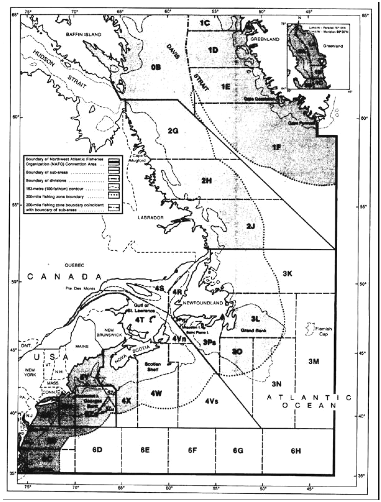
ANNEX IIIU.K.DESCRIPTION OF THE NAFO SUB-AREAS AND DIVISIONS USED FOR THE PURPOSE OF FISHERY STATISTICS AND REGULATIONS IN THE NORTH-WEST ATLANTIC
The scientific and statistical sub-areas, divisions and subdivisions provided for by Article XX of the Convention of the Northwest Atlantic Fisheries Organisation are as follows:
Sub-area 0U.K.
That portion of the convention area bounded on the south by a line extending due east from a point at 61o00′ north latitude and 65o00′ west longitude to a point at 61o00′ north latitude and 59o00′ west longitude, thence in a south-easterly direction along a rhumb line to a point at 60o12′ north latitude and 57o13′ west longitude; thence bounded on the east by a series of geodesic lines joining the following points:
| Point No | Latitude | Longitude |
|---|---|---|
| 1 | 60o12′0 | 57o13′0 |
| 2 | 61o00′0 | 57o13′1 |
| 3 | 62o00′5 | 57o21′1 |
| 4 | 62o02′3 | 57o21′8 |
| 5 | 62o03′5 | 57o22′2 |
| 6 | 62o11′5 | 57o25′4 |
| 7 | 62o47′2 | 57o41′0 |
| 8 | 63o22′8 | 57o57′4 |
| 9 | 63o28′6 | 57o59′7 |
| 10 | 63o35′0 | 58o02′0 |
| 11 | 63o37′2 | 58o01′2 |
| 12 | 63o44′1 | 57o58′8 |
| 13 | 63o50′1 | 57o57′2 |
| 14 | 63o52′6 | 57o56′6 |
| 15 | 63o57′4 | 57o53′5 |
| 16 | 64o04′3 | 57o49′1 |
| 17 | 64o12′2 | 57o48′2 |
| 18 | 65o06′0 | 57o44′1 |
| 19 | 65o08′9 | 57o43′9 |
| 20 | 65o11′6 | 57o44′4 |
| 21 | 65o14′5 | 57o45′1 |
| 22 | 65o18′1 | 57o45′8 |
| 23 | 65o23′3 | 57o44′9 |
| 24 | 65o34′8 | 57o42′3 |
| 25 | 65o37′7 | 57o41′9 |
| 26 | 65o50′9 | 57o40′7 |
| 27 | 65o51′7 | 57o40′6 |
| 28 | 65o57′6 | 57o40′1 |
| 29 | 66o03′5 | 57o39′6 |
| 30 | 66o12′9 | 57o38′2 |
| 31 | 66o18′8 | 57o37′8 |
| 32 | 66o24′6 | 57o37′8 |
| 33 | 66o30′3 | 57o38′3 |
| 34 | 66o36′1 | 57o39′2 |
| 35 | 66o37′9 | 57o39′6 |
| 36 | 66o41′8 | 57o40′6 |
| 37 | 66o49′5 | 57o43′0 |
| 38 | 67o21′6 | 57o52′7 |
| 39 | 67o27′3 | 57o54′9 |
| 40 | 67o28′3 | 57o55′3 |
| 41 | 67o29′1 | 57o56′1 |
| 42 | 67o30′7 | 57o57′8 |
| 43 | 67o35′3 | 58o02′2 |
| 44 | 67o39′7 | 58o06′2 |
| 45 | 67o44′2 | 58o09′9 |
| 46 | 67o56′9 | 58o19′8 |
| 47 | 68o01′8 | 58o23′3 |
| 48 | 68o04′3 | 58o25′0 |
| 49 | 68o06′8 | 58o26′7 |
| 50 | 68o07′5 | 58o27′2 |
| 51 | 68o16′1 | 58o34′1 |
| 52 | 68o21′7 | 58o39′0 |
| 53 | 68o25′3 | 58o42′4 |
| 54 | 68o32′9 | 59o01′8 |
| 55 | 68o34′0 | 59o04′6 |
| 56 | 68o37′9 | 59o14′3 |
| 57 | 68o38′0 | 59o14′6 |
| 58 | 68o56′8 | 60o02′4 |
| 59 | 69o00′8 | 60o09′0 |
| 60 | 69o06′8 | 60o18′5 |
| 61 | 69o10′3 | 60o23′8 |
| 62 | 69o12′8 | 60o27′5 |
| 63 | 69o29′4 | 60o51′6 |
| 64 | 69o49′8 | 60o58′2 |
| 65 | 69o55′3 | 60o59′6 |
| 66 | 69o55′8 | 61o00′0 |
| 67 | 70o01′6 | 61o04′2 |
| 68 | 70o07′5 | 61o08′1 |
| 69 | 70o08′8 | 61o08′8 |
| 70 | 70o13′4 | 61o10′6 |
| 71 | 70o33′1 | 61o17′4 |
| 72 | 70o35′6 | 61o20′6 |
| 73 | 70o48′2 | 61o37′9 |
| 74 | 70o51′8 | 61o42′7 |
| 75 | 71o12′1 | 62o09′1 |
| 76 | 71o18′9 | 62o17′5 |
| 77 | 71o25′9 | 62o25′5 |
| 78 | 71o29′4 | 62o29′3 |
| 79 | 71o31′8 | 62o32′0 |
| 80 | 71o32′9 | 62o33′5 |
| 81 | 71o44′7 | 62o49′6 |
| 82 | 71o47′3 | 62o53′1 |
| 83 | 71o52′9 | 63o03′9 |
| 84 | 72o01′7 | 63o21′1 |
| 85 | 72o06′4 | 63o30′9 |
| 86 | 72o11′0 | 63o41′0 |
| 87 | 72o24′8 | 64o13′2 |
| 88 | 72o30′5 | 64o26′1 |
| 89 | 72o36′3 | 64o38′8 |
| 90 | 72o43′7 | 64o54′3 |
| 91 | 72o45′7 | 64o58′4 |
| 92 | 72o47′7 | 65o00′9 |
| 93 | 72o50′8 | 65o07′6 |
| 94 | 73o18′5 | 66o08′3 |
| 95 | 73o25′9 | 66o25′3 |
| 96 | 73o31′1 | 67o15′1 |
| 97 | 73o36′5 | 68o05′5 |
| 98 | 73o37′9 | 68o12′3 |
| 99 | 73o41′7 | 68o29′4 |
| 100 | 73o46′1 | 68o48′5 |
| 101 | 73o46′7 | 68o51′1 |
| 102 | 73o52′3 | 69o11′3 |
| 103 | 73o57′6 | 69o31′5 |
| 104 | 74o02′2 | 69o50′3 |
| 105 | 74o02′6 | 69o52′0 |
| 106 | 74o06′1 | 70o06′6 |
| 107 | 74o07′5 | 70o12′5 |
| 108 | 74o10′0 | 70o23′1 |
| 109 | 74o12′5 | 70o33′7 |
| 110 | 74o24′0 | 71o25′7 |
| 111 | 74o28′6 | 71o45′8 |
| 112 | 74o44′2 | 72o53′0 |
| 113 | 74o50′6 | 73o02′8 |
| 114 | 75o00′0 | 73o16′3 |
| 115 | 75o05′ | 73o30′ |
and thence due north to the parallel of 78o10′ north latitude; and bounded on the west by a line beginning at 61o00′ north latitude and 65o00′ west longitude and extending in a north-westerly direction along a rhumb line to the coast of Baffin Island at East Bluff (61o55′ north latitude and 66o20′ west longitude), and thence in a northerly direction along the coast of Baffin Island, Bylot Island, Devon Island and Ellesmere Island and following the meridian of 80o west longitude in the waters between those islands to 78o10′ north latitude; and bounded on the north by the parallel of 78o10′ north latitude.
Sub-area 0 is composed of two divisions
Division 0AU.K.
That portion of the sub-area lying to the north of the parallel of 66o15′ north latitude.
Division 0BU.K.
That portion of the sub-area lying to the south of the parallel of 66o15′ north latitude.
Sub-area 1U.K.
That portion of the convention area lying to the east of sub-area 0 and to the north and east of a rhumb line joining a point at 60o12′ north latitude and 57o13′ west longitude with a point at 52o15′ north latitude and 42o00′ west longitude.
Sub-area 1 is composed of six divisions
Division 1AU.K.
That portion of the sub-area lying north of the parallel of 68o50′ north latitude (Christianshaab).
Division 1BU.K.
That portion of the sub-area lying between the parallel of 66o15′ north latitude (5 nautical miles north of Umanarsugssuak) and the parallel of 68o50′ north latitude (Christianshaab).
Division 1CU.K.
That portion of the sub-area lying between the parallel of 64o15′ north latitude (4 nautical miles north of Godthaab) and the parallel of 66o15′ north latitude (5 nautical miles north of Umanarsugssuak).
Division 1DU.K.
That portion of the sub-area lying between the parallel of 62o30′ north latitude (Frederikshaab Glacier) and the parallel of 64o15′ north latitude (4 nautical miles north of Godthaab).
Division 1EU.K.
That portion of the sub-area lying between the parallel of 60o45′ north latitude (Cape Desolation) and the parallel of 62o30′ north latitude (Frederikshaab Glacier).
Division 1FU.K.
That portion of the sub-area lying south of the parallel of 60o45′ north latitude (Cape Desolation).
Sub-area 2U.K.
That portion of the convention area lying to the east of the meridian of 64o30′ west longitude in the area of Hudson Strait, to the south of sub-area 0, to the south and west of sub-area 1 and to the north of the parallel of 52o15′ north latitude.
Sub-area 2 is composed of three divisions
Division 2GU.K.
That portion of the sub-area lying north of the parallel of 57o40′ north latitude (Cape Mugford).
Division 2HU.K.
That portion of the sub-area lying between the parallel of 55o20′ north latitude (Hopedale) and the parallel of 57o40′ north latitude (Cape Mugford).
Division 2JU.K.
That portion of the sub-area lying south of the parallel of 55o20′ north latitude (Hopedale).
Sub-area 3U.K.
That portion of the convention area lying south of the parallel of 52o15′ north latitude, and to the east of a line extending due north from Cape Bauld on the north coast of Newfoundland to 52o15′ north latitude; to the north of the parallel of 39o00′ north latitude; and to the east and north of a rhumb line commencing at 39o00′ north latitude, 50o00′ west longitude and extending in a north-westerly direction to pass through a point at 43o30′ north latitude, 55o00′ west longitude in the direction of a point at 47o50′ north latitude, 60o00′ west longitude until it intersects a straight line connecting Cape Ray, 47o37,0′ north latitude; 59o18,0′ west longitude on the coast of Newfoundland, with Cape North, 47o02,0′ north latitude; 60o25,0′ west longitude on Cape Breton Island; thence in a north-easterly direction along said line to Cape Ray, 47o37,0′ north latitude, 59o18,0′ west longitude.
Sub-area 3 is composed of six divisions
Division 3KU.K.
That portion of the sub-area lying north of the parallel of 49o15′ north latitude (Cape Freels, Newfoundland).
Division 3LU.K.
That portion of the sub-area lying between the Newfoundland coast from Cape Freels to Cape St Mary and a line described as follows: beginning at Cape Freels, thence due east to the meridian of 46o30′ west longitude, thence due south to the parallel of 46o00′ north latitude, thence due west to the meridian of 54o30′ west longitude, thence along a rhumb line to Cape St Mary, Newfoundland.
Division 3MU.K.
That portion of the sub-area lying south of the parallel of 49o15′ north latitude and east of the meridian of 46o30′ west longitude.
Division 3NU.K.
That portion of the sub-area lying south of the parallel of 46o00′ north latitude and between the meridian of 46o30′ west longitude and the meridian of 51o00′ west longitude.
Division 3OU.K.
That portion of the sub-area lying south of the parallel of 46o00′ north latitude and between the meridian of 51o00′ west longitude and the meridian of 54o30′ west longitude.
Division 3PU.K.
That portion of the sub-area lying south of the Newfoundland coast and west of a line from Cape St Mary, Newfoundland to a point at 46o00′ north latitude, 54o30′ west longitude, thence due south to a limit of the sub-area.
Division 3P is divided into two subdivisions:
3Pn — north-western subdivision — that portion of division 3P lying north-west of a line extending from 47o30,7′ north latitude; 57o43,2′ west longitude, approximately south-west to a point at 46o50,7′ north latitude and 58o49,0′ west longitude;
3Ps — south-eastern subdivision — that portion of division 3P lying south-east of the line defined for subdivision 3Pn.
Sub-area 4U.K.
That portion of the convention area lying north of the parallel of 39o00′ north latitude, to the west of sub-area 3, and to the east of a line described as follows:
beginning at the terminus of the international boundary between the United States of America and Canada in Grand Manan Channel, at a point at 44o46′35,346″ north latitude; 66o54′11,253″ west longitude; thence due south to the parallel of 43o50′ north latitude; thence due west to the meridian of 67o24′27,24″ west longitude; thence along a geodetic line in a south-westerly direction to a point at 42o53′14″ north latitude and 67o44′35″ west longitude; thence along a geodetic line in a south-easterly direction to a point at 42o31′08″ north latitude and 67o28′05″ west longitude; thence along a geodetic line to a point at 42o20′ north latitude and 67o18′13,15″ west longitude;
thence due east to a point at 66o00′ west longitude; thence along a rhumb line in a south-easterly direction to a point at 42o00′ north latitude and 65o40′ west longitude and thence due south to the parallel of 39o00′ north latitude.
Sub-area 4 is composed of six divisions
Division 4RU.K.
That portion of the sub-area lying between the coast of Newfoundland from Cape Bauld to Cape Ray and a line described as follows: beginning at Cape Bauld, thence due north to the parallel of 52o15′ north latitude, thence due west to the Labrador coast, thence along the Labrador coast to the terminus of the Labrador-Quebec boundary, thence along a rhumb line in a south-westerly direction to a point at 49o25′ north latitude, 60o00′ west longitude, thence due south to a point at 47o50′ north latitude, 60o00′ west longitude, thence along a rhumb line in a south-easterly direction to the point at which the boundary of sub-area 3 intersects the straight line joining Cape North, Nova Scotia with Cape Ray, Newfoundland, thence to Cape Ray, Newfoundland.
Division 4SU.K.
That portion of the sub-area lying between the south coast of Quebec from the terminus of the Labrador-Quebec boundary to Pointe-des-Monts and a line described as follows: beginning at Pointe-des-Monts, thence due east to a point at 49o25′ north latitude, 64o40′ west longitude, thence along a rhumb line in an east-south-easterly direction to a point at 47o50′ north latitude, 60o00′ west longitude, thence due north to a point at 49o25′ north latitude, 60o00′ west longitude, thence along a rhumb line in a north-easterly direction to the terminus of the Labrador-Quebec boundary.
Division 4TU.K.
That portion of the sub-area lying between the coasts of Nova Scotia, New Brunswick and Quebec from Cape North to Pointe-des-Monts and a line described as follows: beginning at Pointe-des-Monts, thence due east to a point at 49o25′ north latitude, 64o40′ west longitude, thence along a rhumb line in a south-easterly direction to a point at 47o50′ north latitude, 60o00′ west longitude, thence along a rhumb line in a southerly direction to Cape North, Nova Scotia.
Division 4VU.K.
That portion of the sub-area lying between the coast of Nova Scotia between Cape North and Fourchu and a line described as follows: beginning at Fourchu, thence along a rhumb line in an easterly direction to a point at 45o40′ north latitude, 60o00′ west longitude, thence due south along the meridian of 60o00′ west longitude to the parallel of 44o10′ north latitude, thence due east to the meridian of 59o00′ west longitude, thence due south to the parallel of 39o00′ north latitude, thence due east to a point where the boundary between sub-areas 3 and 4 meets the parallel of 39o00′ north latitude, thence along the boundary between sub-areas 3 and 4 and a line continuing in a north-westerly direction to a point at 47o50′ north latitude, 60o00′ west longitude, and thence along a rhumb line in a southerly direction to Cape North, Nova Scotia.
Division 4V is divided into two subdivisions:
4Vn — northern subdivision — that portion of division 4V lying north of the parallel of 45o40′ north latitude;
4Vs — southern subdivision — that portion of division 4V lying south of the parallel of 45o40′ north latitude.
Division 4WU.K.
That portion of the sub-area lying between the coast of Nova Scotia from Halifax to Fourchu and a line described as follows: beginning at Fourchu, thence along a rhumb line in an easterly direction to a point at 45o40′ north latitude, 60o00′ west longitude, thence due south along the meridian of 60o00′ west longitude to the parallel of 44o10′ north latitude, thence due east to the meridian of 59o00′ west longitude, thence due south to the parallel of 39o00′ north latitude, thence due west to the meridian of 63o20′ west longitude, thence due north to a point on that meridian at 44o20′ north latitude, thence along a rhumb line in a north-westerly direction to Halifax, Nova Scotia.
Division 4XU.K.
That portion of the sub-area lying between the western boundary of sub-area 4 and the coasts of New Brunswick and Nova Scotia from the terminus of the boundary between New Brunswick and Maine to Halifax, and a line described as follows: beginning at Halifax, thence along a rhumb line in a south-easterly direction to a point at 44o20′ north latitude, 63o20′ west longitude, thence due south to the parallel of 39o00′ north latitude, and thence due west to the meridian of 65o40′ west longitude.
Sub-area 5U.K.
That portion of the convention area lying to the west of the western boundary of sub-area 4, to the north of the parallel of 39o00′ north latitude, and to the east of the meridian of 71o40′ west longitude.
Sub-area 5 is composed of two divisions
Division 5YU.K.
That portion of the sub-area lying between the coasts of Maine, New Hampshire and Massachusetts from the border between Maine and New Brunswick to 70o00′ west longitude on Cape Cod (at approximately 42o north latitude) and a line described as follows: beginning at a point on Cape Cod at 70o west longitude (at approximately 42o north latitude), thence due north to 42o20′ north latitude, thence due east to 67o18′13,15″ west longitude at the boundary of sub-areas 4 and 5, and thence along that boundary to the boundary of Canada and the United States.
Division 5ZU.K.
That portion of the sub-area lying to the south and east of division 5Y.
Division 5Z is divided into two subdivisions: an eastern subdivision and a western subdivision defined as follows:
5Ze — eastern subdivision — that portion of division 5Z lying east of the meridian of 70o00′ west longitude;
Subdivision 5Ze is sub-divided into two sub-units(1):
5Zu (United States waters) is that part of subdivision 5Ze to the west of the geodetic lines connecting the points with the following coordinates:
| Latitude north | Longitude west | |
|---|---|---|
| A | 44o11′12″ | 67o16′46″ |
| B | 42o53′14″ | 67o44′35″ |
| C | 42o31′08″ | 67o28′05″ |
| D | 40o27′05″ | 65o41′59″. |
5Zc (Canadian waters) is that part of subdivision 5Ze to the east of the abovementioned geodetic lines;
5Zw — western subdivision — that portion of division 5Z lying west of the meridian of 70o00′ west longitude.
Sub-area 6U.K.
That part of the convention area bounded by a line beginning at a point on the coast of Rhode Island at 71o40′ west longitude, thence due south to 39o00′ north latitude, thence due east to 42o00′ west longitude, thence due south to 35o00′ north latitude, thence due west to the coast of North America, thence northwards along the coast of North America to the point on Rhode Island at 71o40′ west longitude.
Sub-area 6 is composed of eight divisions
Division 6AU.K.
That portion of the sub-area lying to the north of the parallel of 39o00′ north latitude and to the west of sub-area 5.
Division 6BU.K.
That portion of the sub-area lying to the west of 70o00′ west longitude, to the south of the parallel of 39o00′ north latitude, and to the north and west of a line running westward along the parallel of 37o00′ north latitude to 76o00′ west longitude and thence due south to Cape Henry, Virginia.
Division 6CU.K.
That portion of the sub-area lying to the west of 70o00′ west longitude and to the south of division 6B.
Division 6DU.K.
That portion of the sub-area lying to the east of divisions 6B and 6C and to the west of 65o00′ west longitude.
Division 6EU.K.
That portion of the sub-area lying to the east of division 6D and to the west of 60o00′ west longitude.
Division 6FU.K.
That portion of the sub-area lying to the east of division 6E and to the west of 55o00′ west longitude.
Division 6GU.K.
That portion of the sub-area lying to the east of division 6F and to the west of 50o00′ west longitude.
Division 6HU.K.
That portion of the sub-area lying to the east of division 6G and to the west of 42o00′ west longitude.
ANNEX IVU.K.DEFINITIONS AND CODING TO BE USED IN THE SUBMISSION OF CATCH DATA
(A)LIST OF FISHING GEAR/FISHING VESSEL CATEGORIESU.K.
(from the International Standard Statistical Classification of Fishing Gears (ISSCFG))
| Category | Abbreviation |
|---|---|
| Trawls | |
| Bottom trawls | |
| TBB |
| OTB |
| OTB1 |
| OTB2 |
| PTB |
| TBS |
| TBN |
| TB |
| Midwater trawls | |
| OTM |
| OTM1 |
| OTM2 |
| PTM |
| TMS |
| TM |
| Twin trawl | OTS |
| Otter twin trawls | OTT |
| Pair trawls (two vessels) (not specified) | PT |
| Otter trawls (not specified) | OT |
| Other trawls (not specified) | TX |
| Seine nets | |
| Beach seines | SB |
| Boat or vessel seines | SV |
| SDN |
| SSC |
| SPR |
| Seine nets (not specified) | SX |
| Surrounding nets | |
| With purse lines (purse seine) | PS |
| PS1 |
| PS2 |
| Without purse lines (lampara) | LA |
| Gillnets and entangling nets | |
| Set gillnets (anchored) | GNS |
| Drift gillnets | GND |
| Encircling gillnets | GNC |
| Fixed gillnets (on stakes) | GNF |
| Trammel nets | GTR |
| Combined gillnet-trammel nets | GTN |
| Gillnets and entangling nets (not specified) | GEN |
| Gillnets (not specified) | GN |
| Hooks and lines | |
| Set longlines | LLS |
| Drift longlines | LLD |
| Longlines (not specified) | LL |
| Handlines and polelines (hand-operated) | LHP |
| Handlines and polelines (mechanised) | LTM |
| Trolling lines | LTL |
| Hooks and lines (not specified) | LX |
| Traps | |
| Stationary uncovered poundnets | FPN |
| Covered pots | FPO |
| Fyke nets | FYK |
| Barriers, fences, weirs, etc. | FWR |
| Stownets | FSN |
| Aerial nets | FAR |
| Traps (not specified) | FIX |
| Falling gear | |
| Cast nets | FCN |
| Falling gear (unspecified) | FG |
| Dredges | |
| Boat dredge | DRB |
| Hand dredge | DRH |
| Grappling and wounding | |
| Harpoon | HAR |
| Lift nets | |
| Portable lift nets | LNP |
| Boat-operated lift nets | LNB |
| Shore-operated stationary lift nets | LNS |
| Lift nets (not specified) | LN |
| Harvesting machines | |
| Pumps | HMP |
| Mechanised dredges | HMD |
| Harvesting machines (not specified) | HMX |
| Miscellaneous gears | MIS |
| Gear not known | NK |
(B)DEFINITIONS OF FISHING EFFORT MEASURES FOR GEAR CATEGORIESU.K.
Three levels of precisions of fishing effort should be provided, where possible.
Category AU.K.
| Fishing gear | Effort measure | Definitions |
|---|---|---|
| Surrounding nets (purse seines) | Number of sets | Number of times the gear has been set or shot, whether or not a catch was made. This measure is appropriate when shoal size and packing is related to stock abundance or sets are made in a random manner |
| Beach seines | Number of sets | Number of times the gear has been set or shot, whether or not a catch was made |
| Boat seines | Number of hours fished | Number of times the gear was set or shot times the estimated mean set or shot duration |
| Trawls | Number of hours | Number of hours during which the trawl was in the water (midwater trawl) or on the bottom (bottom trawl), and fishing |
| Boat dredges | Number of hours fished | Number of hours during which the dredge was on the bottom and fishing |
| Gillnets (set or drift) | Number of effort units | Length of nets expressed in 100-metre units multiplied by the number of sets made (= accumulated total length in metres of net used in a given time divided by 100) |
| Gillnets (fixed) | Number of effort units | Length of net expressed in 100-metre units multiplied by the number of times the net was cleared |
| Traps (uncovered pound nets) | Number of effort units | Number of days fished times the number of units hauled |
| Covered pots and fyke nets | Number of effort units | Number of lifts times the number of units (= total number of units fished in a given time period) |
| Longlines (set or drift) | Thousands of hooks | Number of hooks fished in a given time period divided by 1 000 |
| Handlines (pole, troll, jig, etc.) | Number of line days | Total number of lines used in a given time period |
| Harpoons | (Report effort levels B and C only) |
Category BU.K.
Numbers of days fished: the number of days on which fishing took place. For those fisheries in which searching is a substantial part of the fishing operation, days in which searching but no fishing took place should be included in ‘days fished’ data.
Category CU.K.
For number of days on ground in addition to days fished and searching also all other days while the vessel was on the ground should be included.
Per cent of estimated effort (prorated effort)
Since corresponding effort measures may not be available for the total catch, the percentage of the effort that has been estimated should be indicated. This is calculated from:
(((Total catch) - (Catch for which effort has been recorded)) × 100)/(Total catch)
(C)VESSEL SIZE CATEGORIESU.K.
(from the International Standard Statistical Classification of Fishing Vessels (ISSCFV))
Tonnage classes
| Gross tonnage category | Code |
|---|---|
| 0-49,9 | 02 |
| 50-149,9 | 03 |
| 150-499,9 | 04 |
| 500-999,9 | 05 |
| 1 000-1 999,9 | 06 |
| 2 000-99 999,9 | 07 |
| Not known | 00 |
(D)MAIN SPECIES SOUGHTU.K.
This is the species to which the fishing was principally directed. However, it may not correspond with the species which formed the greater part of the catch. The species should be indicated using the 3-alpha identifier (see Annex I).
ANNEX VU.K.FORMAT FOR THE SUBMISSION OF DATA ON MAGNETIC MEDIA
(A)MAGNETIC MEDIAU.K.
| Computer tapes: | Nine-track with a density of 1600 or 6250-BPI and EBCDIC of ASCII coding, preferably labelled. If labelled, an end-of-file code should be included. |
| Floppy disks: | MS-DOS-formatted, 3,5″ 720 K or 1,4 MB disks or 5,25″ 360 K or 1,2 MB disks. |
(B)CODING FORMATU.K.
For submissions pursuant to Article 2(1)(a)
| Byte Nos | Item | Remarks |
|---|---|---|
| 1 to 4 | Country (ISO 3-alpha code) | e.g. FRA = France |
| 5 to 6 | Year | e.g. 90 = 1990 |
| 7 to 8 | FAO major fishing area | 21 = north-west Atlantic |
| 9 to 15 | Division | e.g. 3 Pn = NAFO sub-division 3 Pn |
| 16 to 18 | Species | 3-alpha identifier |
| 19 to 26 | Catch | tonnes |
For submissions pursuant to Article 2(1)(b)
| Byte Nos | Item | Remarks |
|---|---|---|
| 1 to 4 | Country | ISO 3-alpha code (e.g. FRA = France) |
| 5 to 6 | Year | e.g. 94 = 1994 |
| 7 to 8 | Month | e.g. 01 = January |
| 9 to 10 | FAO major fishing area | 21 = north-west Atlantic |
| 11 to 18 | Division | e.g. 3 Pn = NAFO sub-division 3 Pn: alpha-numeric |
| 19 to 21 | Main species sought | 3-alpha identifier |
| 22 to 26 | Vessel/gear category | ISSCFG code (e.g. OTB2 = Bottom otter trawl): alpha-numeric |
| 27 to 28 | Vessel size class | ISSCFV code (e.g. 04 = 150-499.9 GT): alpha-numeric |
| 29 to 34 | Average gross tonnage | Tonnes: numeric |
| 35 to 43 | Average engine power | Kilowatts: numeric |
| 44 to 45 | Percentage effort estimated | Numeric |
| 46 to 48 | Unit | 3-alpha identifier of species or effort identifier (e.g. COD = Atlantic cod A— = Effort measure A) |
| 49 to 56 | Data | Catch (in metric tonnes) or effort unit |
NotesU.K.
(a)
All numeric fields should be right justified with leading blanks. All alphanumeric fields should be left justified with trailing blanks.
(b)
The catch is to be recorded in the live weight equivalent of the landings to the nearest metric tonne.
(c)
Quantities (bytes 49 to 56) of less than half a unit should be recorded as ‘-1’.
(d)
Unknown quantities (bytes 49 to 56) should be recorded as ‘-2’.
(e)
Country codes (ISO codes):
| Austria | AUT |
| Belgium | BEL |
| Bulgaria | BGR |
| Cyprus | CYP |
| Czech Republic | CZE |
| Germany | DEU |
| Denmark | DNK |
| Spain | ESP |
| Estonia | EST |
| Finland | FIN |
| France | FRA |
| United Kingdom | GBR |
| England & Wales | GBRA |
| Scotland | GBRB |
| Northern Ireland | GBRC |
| Greece | GRC |
| Hungary | HUN |
| Ireland | IRL |
| Iceland | ISL |
| Italy | ITA |
| Lithuania | LTU |
| Luxembourg | LUX |
| Latvia | LVA |
| Malta | MLT |
| Netherlands | NLD |
| Norway | NOR |
| Poland | POL |
| Portugal | PRT |
| Romania | ROU |
| Slovakia | SVK |
| Slovenia | SVN |
| Sweden | SWE |
| Turkey | TUR |
ANNEX VIU.K.FORMAT FOR THE SUBMISSION OF DATA ON MAGNETIC MEDIA
A.CODING FORMATU.K.
For submissions pursuant to Article 2(1)(a)U.K.
The data should be submitted as variable length records with a colon (:) between the fields of the record. The following fields should be included in each record:
| Field | Remarks |
|---|---|
| Country | ISO 3-alpha code (e.g. FRA = France) |
| Year | e.g. 2001 or 01 |
| FAO major fishing area | 21 = north-west Atlantic |
| Division | e.g. 3 Pn = NAFO subdivision 3 Pn |
| Species | 3-alpha identifier |
| Catch | Tonnes |
For submissions pursuant to Article 2(1)(b)U.K.
The data should be submitted as variable length records with a colon (:) between the fields of the record. The following fields should be included in each record:
| Field | Remarks |
|---|---|
| Country | ISO 3-alpha code (e.g. FRA = France) |
| Year | e.g. 0001 or 2001 for the year 2001 |
| Month | e.g. 01 = January |
| FAO major fishing area | 21 = north-west Atlantic |
| Division | e.g. 3 Pn = NAFO subdivision 3 Pn |
| Main species sought | 3-alpha identifier |
| Vessel/gear category | ISSCFG code (e.g. 0TB2 = bottom otter trawl) |
| Vessel size class | ISSCFV code (e.g. 04 = 150-499,9 GT): |
| Average gross tonnage | Tonnes |
| Average engine power | Kilowatts |
| Percentage effort estimated | Numeric |
| Unit | 3-alpha identifier of species or effort identifier (e.g. COD = Atlantic cod or A = effort measure A) |
| Data | Catch (in metric tonnes) or effort unit |
(a)
The catch is to be recorded in the live weight equivalent of the landings.
(b)
Country codes:
| Austria | AUT |
| Belgium | BEL |
| Bulgaria | BGR |
| Cyprus | CYP |
| Czech Republic | CZE |
| Germany | DEU |
| Denmark | DNK |
| Spain | ESP |
| Estonia | EST |
| Finland | FIN |
| France | FRA |
| United Kingdom | GBR |
| England and Wales | GBRA |
| Scotland | GBRB |
| Northern Ireland | GBRC |
| Greece | GRC |
| Hungary | HUN |
| Ireland | IRL |
| Iceland | ISL |
| Italy | ITA |
| Lithuania | LTU |
| Luxemburg | LUX |
| Latvia | LVA |
| Malta | MLT |
| Netherlands | NLD |
| Norway | NOR |
| Poland | POL |
| Portugal | PRT |
| Romania | ROU |
| Slovak Republic | SVK |
| Slovenia | SVN |
| Sweden | SWE |
| Turkey | TUR |
B.METHOD OF TRANSMISSION OF THE DATA TO THE EUROPEAN COMMISSIONU.K.
As far as is possible, the data should be transmitted in an electronic format (for example as an e-mail attachment).
Failing this, the submission of a file on a 3,5" HD floppy disk will be accepted.
ANNEX VIIU.K.Repealed Regulation with list of its successive amendments
| Council Regulation (EEC) No 2018/93 | |
| Point X.6 of Annex I to the 1994 Act of Accession | |
| Commission Regulation (EC) No 1636/2001 | |
| Regulation (EC) No 1882/2003 of the European Parliament and of the Council | Article 3 and point 44 of Annex III only |
| Point 10.9 of Annex II to the 2003 Act of Accession |
ANNEX VIIIU.K.Correlation table
| Regulation (EEC) No 2018/93 | This Regulation |
|---|---|
| Article 1 | Article 1 |
| Article 2 | Article 2 |
| Article 3 | Article 3 |
| Article 4 | Article 4 |
| Article 5 | Article 5 |
| Article 6(1) and (2) | Article 6(1) and (2) |
| Article 6(3) | — |
| Article 7(1) | Article 7(1) |
| Article 7(2) | Article 7(2) |
| Article 7(3) | — |
| Article 7(4) | Article 7(3) |
| Article 8 | — |
| — | Article 8 |
| Article 9 | Article 9 |
| Annex I | Annex I |
| Annex II | Annex II |
| Annex III | Annex III |
| Annex IV | Annex IV |
| Annex V | Annex V |
| — | Annex VI |
| — | Annex VII |
| — | Annex VIII |
(1)
These two sub-units are not recorded in the sixth publication of the NAFO Convention (May 2000). However, following a proposal of the NAFO Scientific Council, they were approved by the NAFO General Council pursuant to Article XX(2) of the NAFO Convention.
Options/Help
Print Options
PrintThe Whole Regulation
PrintThe Annexes only
Legislation is available in different versions:
Latest Available (revised):The latest available updated version of the legislation incorporating changes made by subsequent legislation and applied by our editorial team. Changes we have not yet applied to the text, can be found in the ‘Changes to Legislation’ area.
Original (As adopted by EU): The original version of the legislation as it stood when it was first adopted in the EU. No changes have been applied to the text.
Point in Time: This becomes available after navigating to view revised legislation as it stood at a certain point in time via Advanced Features > Show Timeline of Changes or via a point in time advanced search.
See additional information alongside the content
Geographical Extent: Indicates the geographical area that this provision applies to. For further information see ‘Frequently Asked Questions’.
Show Timeline of Changes: See how this legislation has or could change over time. Turning this feature on will show extra navigation options to go to these specific points in time. Return to the latest available version by using the controls above in the What Version box.
Opening Options
Different options to open legislation in order to view more content on screen at once
More Resources
Access essential accompanying documents and information for this legislation item from this tab. Dependent on the legislation item being viewed this may include:
- the original print PDF of the as adopted version that was used for the EU Official Journal
- lists of changes made by and/or affecting this legislation item
- all formats of all associated documents
- correction slips
- links to related legislation and further information resources
Timeline of Changes
This timeline shows the different versions taken from EUR-Lex before exit day and during the implementation period as well as any subsequent versions created after the implementation period as a result of changes made by UK legislation.
The dates for the EU versions are taken from the document dates on EUR-Lex and may not always coincide with when the changes came into force for the document.
For any versions created after the implementation period as a result of changes made by UK legislation the date will coincide with the earliest date on which the change (e.g an insertion, a repeal or a substitution) that was applied came into force. For further information see our guide to revised legislation on Understanding Legislation.
More Resources
Use this menu to access essential accompanying documents and information for this legislation item. Dependent on the legislation item being viewed this may include:
- the original print PDF of the as adopted version that was used for the print copy
- correction slips
Click 'View More' or select 'More Resources' tab for additional information including:
- lists of changes made by and/or affecting this legislation item
- confers power and blanket amendment details
- all formats of all associated documents
- links to related legislation and further information resources
 All content is available under the Open Government Licence v3.0 except where otherwise stated. This site additionally contains content derived from EUR-Lex, reused under the terms of the Commission Decision 2011/833/EU on the reuse of documents from the EU institutions. For more information see the EUR-Lex public statement on re-use.