- Latest available (Revised)
- Original (As made)
The Derbyshire and Greater Manchester (County Boundaries) Order 1991
You are here:
- UK Statutory Instruments
- 1991 No. 2464
- Whole Instrument
- Previous
- Next

What Version
Opening Options
More Resources
Status:
This is the original version (as it was originally made). This item of legislation is currently only available in its original format.
Statutory Instruments
1991 No. 2464
LOCAL GOVERNMENT, ENGLAND AND WALES
CHANGES IN LOCAL GOVERNMENT AREAS
The Derbyshire and Greater Manchester (County Boundaries) Order 1991
Made
28th October 1991
Laid before Parliament
4th November 1991
Coming into force for
the purposes referred to in article 1(2)
25th November 1991
for all other purposes
1st April 1992
The Secretary of State, in exercise of his powers under section 51(2) and 67(4) of the Local Government Act 1972(1) and of all other powers enabling him in that behalf, hereby makes the following Order which gives effect to proposals submitted to him under sections 47, 48(1) and 51(1) of that Act, more than six weeks before the making of this Order, by the Local Government Boundary Commission for England:
Citation and commencement
1.—(1) This Order may be cited as the Derbyshire and Greater Manchester (County Boundaries) Order 1991.
(2) This Order shall come into force on 25th November 1991 for any purpose set out in regulation 4(1) of the Local Government Area Changes Regulations 1976(2).
(3) For all other purposes, this Order shall come into force on 1st April 1992.
Interpretation
2. In this Order–
“Derbyshire” means the county of Derbyshire, and “electoral division” means an electoral division of that county;
“Greater Manchester” means the metropolitan county of Greater Manchester;
“High Peak” means the borough of High Peak;
“the map” means the map prepared by the Department of the Environment, marked “Map of the Derbyshire and Greater Manchester (County Boundaries) Order 1991”, and deposited in accordance with regulation 5 of the Local Government Area Changes Regulations 1976;
“Tameside” means the metropolitan borough of Tameside; and
“ward” means a ward of the borough to which an area is transferred, except in the expression “parish ward”, where it means a ward of the parish to which an area is transferred.
Transfers from Derbyshire to Greater Manchester
3. Each area which is marked on the map as shown in column 1 of the following Table shall be transferred from Derbyshire, from High Peak, and from the parish (if any) named in column 2 to–
(a)Greater Manchester;
(b)Tameside;
(c)the ward mentioned in column 3;
(d)the South Tameside petty sessional division and the Greater Manchester South coroner’s district.
Where a parish is named in column 2, the relevant area shall cease to form part of any parish, and where the word “unparished” appears in that column, the area shall continue to be unparished.
| Area(s) marked– | Transferred from– | To the following ward of Tameside– |
|---|---|---|
| B9 and B10 | Parish of Charlesworth | Longdendale |
| Table B11 and B12 | Parish of Chisworth | Longdendale |
| B1 | Parish of Tintwistle | Stalybridge South |
| B2, B3 and B4 | Parish of Tintwistle | Longdendale |
| B5, B6, B7 and B8 | Unparished | Longdendale |
Transfers from Greater Manchester to Derbyshire
4. Each area which is marked on the map as shown in column 1 of the following Table shall be transferred from Greater Manchester and from Tameside to–
(a)Derbyshire;
(b)High Peak;
(c)the parish and parish ward (if any) mentioned in column 2;
(d)the ward and electoral division so mentioned;
(e)the Glossop petty sessional division and the High Peak coroner’s district.
Where the word “unparished” appears in column 2, the relevant area shall continue to be unparished.
| 1 | 2 |
|---|---|
| Area(s) marked– | Transferred to– |
| C5, C6, C7 and C8 of | Parish of Charlesworth St Johns ward Glossop South electoral division |
| C9, C10 and C11 | Parish of Chisworth St Johns ward Glossop South electoral division |
| C1, C2, C3 and C4 | Parish of Tintwistle Tintwistle parish ward Tintwistle ward Glossop West electoral division |
| B16 | Unparished Gamesley ward Glossop South electoral division |
| B14 and B15 | Unparished St Andrews ward Glossop West electoral division |
| B13 | Unparished St Charles ward Glossop West electoral division |
Town and country planning
5.—(1) In this article, “provision” means a provision of a development plan (as defined in section 336 of the Town and Country Planning Act 1990(3)).
(2) Any provision applying to an area transferred by this Order shall continue to apply to that area, notwithstanding the transfer, until replaced by a provision which so applies, and which is expressed to supersede the preserved provision.
Signed by authority of the Secretary of State
Robert Key
Parliamentary Under Secretary of State,
Department of the Environment
28th October 1991
Explanatory Note
(This note is not part of the Order)
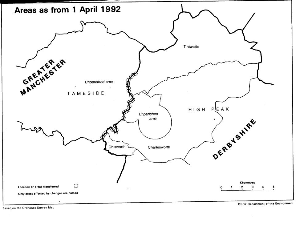
This Order transfers a number of small areas between the county of Derbyshire and the metropolitan county of Greater Manchester, affecting the boundaries of the Derbyshire borough of High Peak and of the metropolitan borough of Tameside. Consequential changes to parishes, unparished areas, local government electoral areas, petty sessional divisions and coroners' districts are made.
The map forming part of this note (page 5) gives a general guide to the areas affected. Prints of the detailed map (described in article 2) may be inspected at all reasonable times at the offices of the High Peak Borough Council, the offices of the Tameside Metropolitan Borough Council, and additionally at the offices of the Secretary of State for the Environment located in 2, Marsham Street, London SW1P 3EB.
In approximate terms, the parts of Derbyshire transferred to Greater Manchester have a total area of 7.4 hectares, and no inhabitants, and the parts of Greater Manchester transferred to Derbyshire have a total area of 18.01 hectares and a population of 2.
The Local Government Area Changes Regulations 1976 contain general provisions regarding the effect of orders such as this one.
Options/Help
Print Options
PrintThe Whole Instrument

Legislation is available in different versions:
Latest Available (revised):The latest available updated version of the legislation incorporating changes made by subsequent legislation and applied by our editorial team. Changes we have not yet applied to the text, can be found in the ‘Changes to Legislation’ area.
Original (As Enacted or Made): The original version of the legislation as it stood when it was enacted or made. No changes have been applied to the text.
Opening Options
Different options to open legislation in order to view more content on screen at once
More Resources
Access essential accompanying documents and information for this legislation item from this tab. Dependent on the legislation item being viewed this may include:
- the original print PDF of the as enacted version that was used for the print copy
- lists of changes made by and/or affecting this legislation item
- confers power and blanket amendment details
- all formats of all associated documents
- correction slips
- links to related legislation and further information resources
 All content is available under the Open Government Licence v3.0 except where otherwise stated. This site additionally contains content derived from EUR-Lex, reused under the terms of the Commission Decision 2011/833/EU on the reuse of documents from the EU institutions. For more information see the EUR-Lex public statement on re-use.